このページはアプリまたはその開発者の公式ページではなく、情報提供および論評を目的として作成された独立した編集出版物です。明示的に別段の記載がない限り、アプリおよびその開発者は、MWM、Apple、Google Play、アプリのパブリッシャー、またはアプリの開発者と提携、承認、後援、認可、またはその他の公式的な関係はなく、このページのいかなる内容も、アプリがMWMのサービスを使用して開発されたことを意味するものではありません。すべての商標、ロゴ、スクリーンショット、その他のコンテンツはそれぞれの所有者の財産です。

OS Maps: Walk, Hike, Run, Bike
3D地形図、リアルタイム安全アラート、信頼性の高いオフラインGPSで、究極のトレイル計画精度を体験。限界なくハイキング、サイクリング、ランニングを楽しむ、几帳面な探検家のために設計。
ダウンロード
2M+ユーザー評価
評価数
90K+開発元
カテゴリ
Navigation対応言語
1最新バージョン
5.5.5サイズ
202.8 MBリリース日
2015年6月10日几帳面な探検家のための高精度ツール
真剣なアウトドアアドベンチャーのために設計された、技術的なマッピング、シームレスなマルチデバイス計画、高度な安全機能で、基本を超えた体験を。
あらゆる尾根を3Dで視覚化
優れた状況認識のために、見事な3Dマップレイヤーと詳細な地形データで、到着前に地形を理解。
ラップトップから山頂まで同期
自動「スナップ・トゥ・パス」テクノロジーでデスクトップで精密なルートを計画し、iPhoneとApple Watchに即座に同期。
よくある質問
について知っておくべきこと OS Maps: Walk, Hike, Run, Bike
OS Mapsとは何ですか?
OS Mapsは、アメリカ全土でのハイキング、サイクリング、ランニングなどのアウトドアアクティビティをユーザーが楽しめるように設計されたアプリケーションです。国立公園、地域の近隣、海岸沿いのトレイルを発見・計画するのに役立ちます。
OS Mapsはどのような種類のアウトドアアクティビティをサポートしていますか?
OS Mapsは、ハイキング、サイクリング、ランニングなど、さまざまなアウトドアアクティビティをサポートしています。さまざまな地形や場所でのこれらのアクティビティに詳細な地図とガイダンスを提供します。
ユーザーはOS Mapsで独自のルートを作成できますか?
はい、OS Mapsではユーザーが独自のトレイルをプロットして、それに沿って歩いたり、共有したり、記録したりできます。このアプリは、ウェイポイント間のルート計画を簡単にするための自動「パスへのスナップ」機能も備えています。
OS Mapsはオフラインマップの使用をサポートしていますか?
はい、OS Mapsはオフラインマップの使用をサポートしています。ユーザーはお気に入りのエリアをダウンロードして、携帯電波がない場所でも地図や選択したルートを表示できます。トレイルやルートをGPXデバイスにエクスポートすることも可能です。
OS Mapsで利用できるマップレイヤーは何ですか?
OS Mapsは、詳細な地形図、航空写真、3Dマップレイヤーを含む複数のマップレイヤーを提供しています。これらのオプションにより、ユーザーはさまざまな詳細レベルで景観を探索できます。
OS MapsはライブGPS追跡と安全機能を提供していますか?
はい、OS Mapsは、ユーザーがルートから外れないようにするためのライブGPS位置追跡とオフコースアラートを提供しています。また、他のユーザーからのトレイルコンディションに関するリアルタイムアップデートのためのコミュニティアラートも含まれています。
OS Mapsは複数のデバイスと互換性がありますか?
はい、OS Mapsでは、単一のアカウントで複数のデバイス間でルートやアクティビティを表示、作成、同期できます。デスクトップでの計画と、モバイルおよびApple Watchでの記録をサポートしています。
ユーザーはOS Mapsから地図を印刷できますか?
はい、OS Mapsは無制限の印刷機能を提供しています。ユーザーはトレイルや地図のコピーを印刷して、アウトドアアクティビティ中に物理的なバックアップを用意できます。
OS Mapsのサブスクリプションの料金はいくらですか?
OS Mapsの月額サブスクリプションは4.99ドルです。年間サブスクリプションは28.99ドルで利用でき、アプリの機能にプレミアムアクセスできます。
OS Mapsのサブスクリプションの管理またはキャンセル方法を教えてください。
購入後、App Storeアプリを通じてOS Mapsのサブスクリプションを管理できます。サブスクリプションは、iOSの設定内の「サブスクリプション」リストにアクセスすることで、いつでもキャンセルできます。
OS Mapsのサブスクリプションは自動更新されますか?
はい、OS Mapsのサブスクリプションはデフォルトで自動更新されます。現在の請求期間の終了の少なくとも24時間前にユーザーが解約しない限り、自動的に更新されます。
OS Mapsのサポートはどこで見つけられますか?
OS Mapsのサポートを見つけ、問題を報告するには、https://www.ordnancesurvey.co.uk/contact-us の連絡先ページにアクセスしてください。このリンクはフィードバックと問題解決のために提供されています。
以下のスクリーンショットと説明は、アプリの公式ストアリスティングから直接取得されたものであり、アプリ開発者の所有物です。
アプリストア
スクリーンショット

バックパックを背負った2人のハイカーが夕暮れ時に丘を登っている様子。「Adventure Outside」という文字とApp Storeエディターズチョイスのバッジ付き
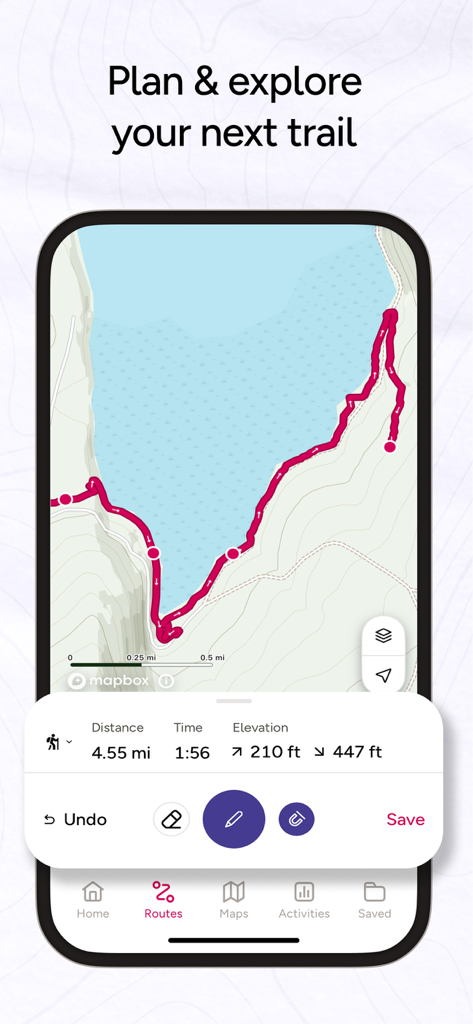
OS Mapsアプリのインターフェースが表示されたスマートフォン。距離、時間、標高の統計情報を含む計画済みの海岸ハイキングルートが表示されている
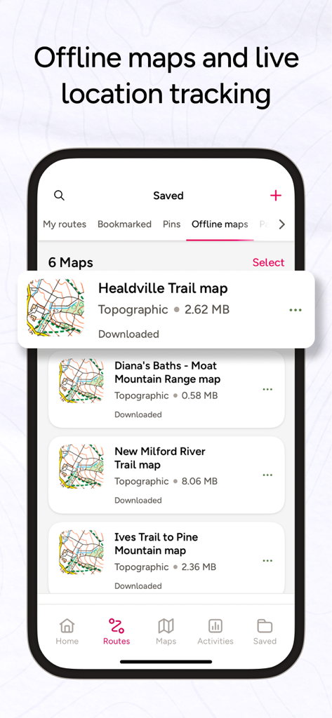
OS Mapsモバイルアプリのインターフェースに、ハイキングやナビゲーション用の保存済みオフライン地形図のリストが表示されている
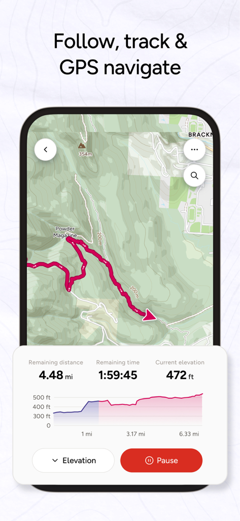
OS Mapsアプリのインターフェースに、ハイキングルートのライブGPS追跡と標高プロファイルが表示されている
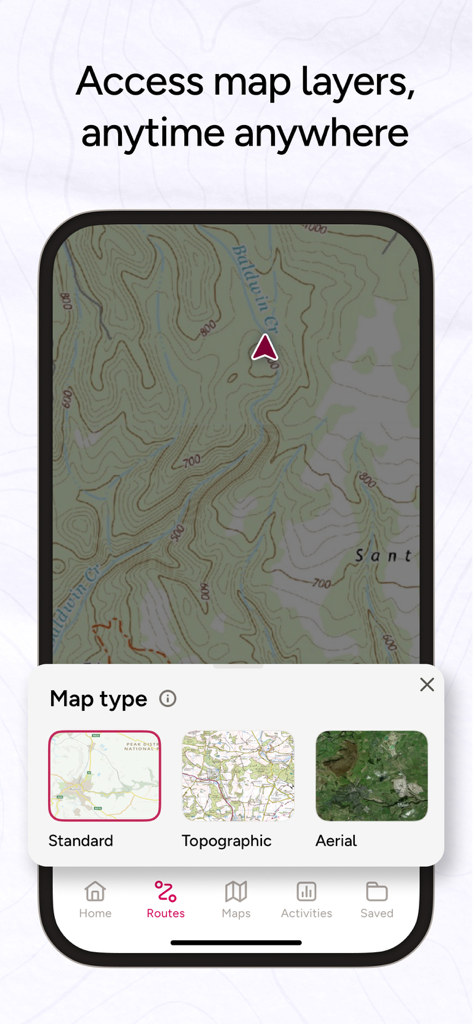
OS Mapsアプリのインターフェースに、地形図と、標準、地形、航空写真のマップレイヤー選択メニューが表示されている

山のトレイルにいる2人のハイカーと、OS Mapsの5つ星レビュー
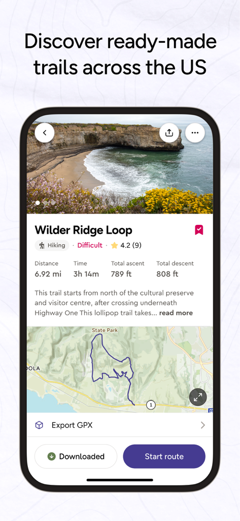
OS Mapsモバイルアプリのインターフェースに、距離、標高、ルートマップを含むハイキングトレイルの詳細が表示されている
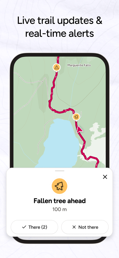
OS Mapsのインターフェースに、倒木などのトレイルの危険に関するライブコミュニティアラートが表示されている
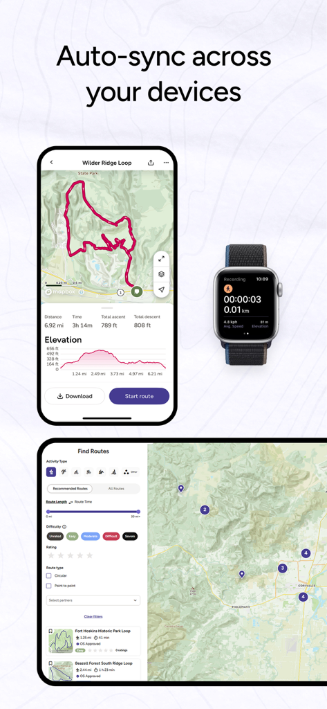
iPhone、Apple Watch、タブレット間で同期されたOS Mapsアプリのインターフェース。ルートの詳細とアクティビティ追跡が表示されている
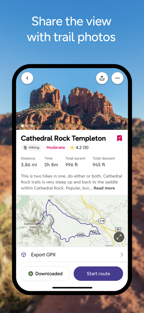
OS Mapsモバイルアプリに、キャセドラルロック・テンプルトンへのハイキングルートの詳細が表示されている。マップと標高統計情報を含む。
説明
Download
類似アプリ
似た機能とユーザー体験を持つアプリ

AllTrails: Hike, Bike & Run
AllTrails, Inc.

Pedometer++
Cross Forward Consulting, LLC

Organic Maps: Offline Map
Organic Maps OU

Gaia GPS: Mobile Trail Maps
Trailbehind, INC.

Offline hiking maps: Mapy.com
Seznam.cz a.s.

Hiking Map Poland
Mapa Turystyczna sp. z o.o.

MapOut
Valnova GmbH

FarOut: Offline GPS Trail Maps
Atlas Guides DE, Inc.

Norgeskart
Norgeskart AS
このページはアプリまたはその開発者の公式ページではなく、情報提供および論評を目的として作成された独立した編集出版物です。明示的に別段の記載がない限り、アプリおよびその開発者は、MWM、Apple、Google Play、アプリのパブリッシャー、またはアプリの開発者と提携、承認、後援、認可、またはその他の公式的な関係はなく、このページのいかなる内容も、アプリがMWMのサービスを使用して開発されたことを意味するものではありません。すべての商標、ロゴ、スクリーンショット、その他のコンテンツはそれぞれの所有者の財産です。