このページはアプリまたはその開発者の公式ページではなく、情報提供および論評を目的として作成された独立した編集出版物です。明示的に別段の記載がない限り、アプリおよびその開発者は、MWM、Apple、Google Play、アプリのパブリッシャー、またはアプリの開発者と提携、承認、後援、認可、またはその他の公式的な関係はなく、このページのいかなる内容も、アプリがMWMのサービスを使用して開発されたことを意味するものではありません。すべての商標、ロゴ、スクリーンショット、その他のコンテンツはそれぞれの所有者の財産です。

ダウンロード
1M+ユーザー評価
評価数
1.5K開発元
カテゴリ
Navigation対応言語
4最新バージョン
1.23.0サイズ
102.0 MBリリース日
2020年7月22日高精度な地図と専門機能がアウトドア愛好家とプロフェッショナルをサポート
スイスの地形を極める: swisstopoアプリの詳細分析
全国詳細地図とオフライン利用
このアプリは、スイスの有名な地形図を様々な縮尺で提供し、航空写真や歴史的地図も利用できます。インターネット接続がない場所でも地図を利用でき、高精度なナビゲーションを可能にします。
専門的なアウトドアルート情報
ユーザーは、公式のハイキング、マウンテンハイキング、アルペンハイキングの各トレイル、スノーシューやスキーのルート、そしてSwitzerlandMobilityのルートなど、詳細かつ信頼性の高い情報を利用できます。リアルタイムのトレイル閉鎖情報も提供されます。
ツアー計画とリアルタイムガイド
ユーザーは独自のルートを作成、記録、インポート、共有でき、ツアータイプ(ハイキング、サイクリング、マウンテンバイク)やペースを設定できます。到着予定時刻や残り距離などのリアルタイムガイド機能も利用できます。
航空情報とドローン規制
パイロットやドローン操縦者向けに、航空図、障害物、空域、着陸地点、そしてドローンや模型航空機の飛行制限に関する重要な情報を提供します。
3Dパノラマビュー
このアプリは、ラベル付きのパノラマモードや3Dビューを提供し、ユーザーは地形を立体的に把握し、計画したルートを視覚的に確認できます。
地点管理とメモ機能
ユーザーは地図上に特定の地点を保存し、メモを追加できます。これらの情報は友人や他のユーザーと共有することも可能です。
高度な検索と計測ツール
本ツールは、地理名称、住所、座標を検索する機能に加え、距離や面積の計測ツールを提供し、ユーザーの計画や分析を支援します。
公共交通機関の接続情報
ユーザーは地図上で公共交通機関の停留所を確認でき、アウトドア活動と公共交通機関の連携を計画するのに役立ちます。
よくある質問
について知っておくべきこと swisstopo
Has the swisstopo app received any awards?
Yes, the swisstopo app won the "Master of Swiss Apps 2021" award, recognizing its quality and functionality.
Is the swisstopo app free to use?
Yes, all functions, data, and offline use of the swisstopo app are completely free of charge.
Does the swisstopo app require a login or display ads?
No, the swisstopo app is free of advertising and does not require users to create an account or log in.
What map scales are available in the swisstopo app?
The swisstopo app offers comprehensive national maps covering all scales from 1:10,000 to 1:1 million.
Does the swisstopo app include historical maps?
Yes, the swisstopo app provides current aerial images and historical maps, enhancing navigation and exploration.
What outdoor activity routes does the swisstopo app offer?
The swisstopo app includes official hiking, mountain hiking, alpine hiking trails, snowshoe routes, and ski routes.
Does the swisstopo app show hiking trail closures?
Yes, the swisstopo app displays current information regarding closures of hiking trails.
Can swisstopo app maps be used offline?
Yes, the swisstopo app offers free offline maps, available in scales from 1:25,000 to 1:1 million.
How do I plan and manage tours with the swisstopo app?
The swisstopo app allows users to draw, record, import, and share their own tours. Users can set tour type and personal pace.
Does the swisstopo app have a panorama mode?
Yes, the swisstopo app features a panorama mode with labelled views and the ability to view tours in 3D.
What search and measurement tools are available in the swisstopo app?
The swisstopo app provides tools for measuring, comparing, and searching geographical names, addresses, or coordinates.
What aviation-specific features does the swisstopo app offer?
The swisstopo app includes aeronautical charts, obstacles, airspaces, landing sites, and restrictions for drones and model aircrafts.
How can I get support for the swisstopo app?
Users can contact support for the swisstopo app by sending an email to support-cd@swisstopo.ch.
以下のスクリーンショットと説明は、アプリの公式ストアリスティングから直接取得されたものであり、アプリ開発者の所有物です。
アプリストア
スクリーンショット
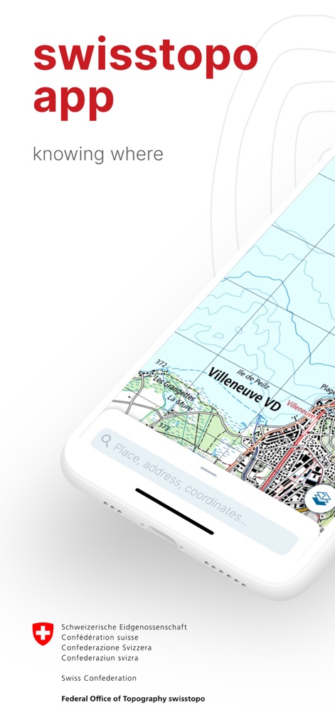
本アプリでは、ユーザーは検索バーを通じて場所、住所、座標を容易に入力でき、詳細な地形図上で目的の地点を素早く特定することが可能です。
直感的な検索
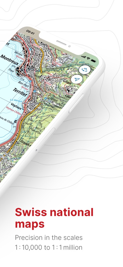
このアプリは、1:10,000から1:100万までの幅広い縮尺に対応したスイスの国家地図を提供し、等高線や建物といった詳細な地形情報でユーザーをサポートします。
スイス国家地図

ユーザーは、航空情報が統合された特別な地図を利用でき、スノースポーツや航空図といった多様なテーマ別データレイヤーを切り替えて表示することが可能です。
豊富な情報レイヤー

この機能は、ランドマークとなる山々の名前と標高を視覚的に表示し、周囲の環境をリアルに体験できる没入型パノラマビューを提供します。
絶景パノラマ

本ツールは、移動距離、所要時間、高低差を含む詳細なツアー情報を提供し、計画ルートの高低差を視覚的に把握できるエレベーションプロファイルグラフを表示します。
詳細なルート計画

ユーザーは、電波状況に左右されずに利用できるオフラインマップ機能を活用でき、ダウンロードサイズやエリア範囲を確認できる地図選択画面で準備を整えられます。
オフライン対応
説明
Download
類似アプリ
似た機能とユーザー体験を持つアプリ

AllTrails: Hike, Bike & Run
AllTrails, Inc.

Pedometer++
Cross Forward Consulting, LLC

Organic Maps: Offline Map
Organic Maps OU

Gaia GPS: Mobile Trail Maps
Trailbehind, INC.

Offline hiking maps: Mapy.com
Seznam.cz a.s.

Hiking Map Poland
Mapa Turystyczna sp. z o.o.

MapOut
Valnova GmbH

FarOut: Offline GPS Trail Maps
Atlas Guides DE, Inc.

Norgeskart
Norgeskart AS
このページはアプリまたはその開発者の公式ページではなく、情報提供および論評を目的として作成された独立した編集出版物です。明示的に別段の記載がない限り、アプリおよびその開発者は、MWM、Apple、Google Play、アプリのパブリッシャー、またはアプリの開発者と提携、承認、後援、認可、またはその他の公式的な関係はなく、このページのいかなる内容も、アプリがMWMのサービスを使用して開発されたことを意味するものではありません。すべての商標、ロゴ、スクリーンショット、その他のコンテンツはそれぞれの所有者の財産です。