이 페이지는 앱이나 개발자의 공식 페이지가 아니며, 정보 제공 및 논평을 목적으로 작성된 독립 편집 간행물입니다. 명시적으로 달리 언급되지 않는 한, 해당 앱이나 개발자는 MWM, Apple, Google Play, 앱 퍼블리셔 또는 앱 개발자와 제휴, 보증, 후원, 승인 또는 공식적으로 연결되어 있지 않으며, 이 페이지의 어떤 내용도 해당 앱이 MWM의 서비스를 사용하여 개발되었음을 의미하지 않습니다. 모든 상표, 로고, 스크린샷 및 기타 콘텐츠는 해당 소유자의 자산입니다.

Earth Maps
당신은 세상의 모든 그림자를 파헤치는 자가 됩니다. Earth Maps는 당신의 호기심을 지배할 권력을 선사합니다.
다운로드
1M+사용자 평점
총 평가 수
8.5K개발사
카테고리
Navigation지원 언어
10최신 버전
1.2.01크기
73.2 MB출시일
2022년 12월 1일정밀한 데이터와 심층 분석 기능을 제공하는 'Earth Maps'의 주요 특징 평가
'Earth Maps' 앱 분석: 전문가를 위한 고급 지리 공간 도구
최신 위성 이미지
이 앱은 최신 위성 이미지를 제공하여 사용자에게 지표면의 현재 상태를 최고 해상도로 확인할 수 있는 기능을 제공합니다.
면적 및 거리 측정
이 도구는 지도상에서 정확한 면적과 거리를 측정할 수 있게 하여, 사용자에게 정밀한 공간 분석 및 기획을 위한 필수적인 기능을 제공합니다.
과거 스트리트 뷰
이 도구는 특정 지역의 과거 스트리트 뷰를 제공하여 시간 경과에 따른 변화를 분석하고, 연구 및 기획에 필요한 과거 데이터를 확보할 수 있습니다.
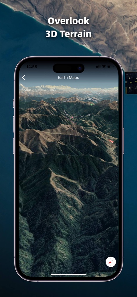
고화질 3D 지구본
이 앱은 전 세계의 지형, 건물, 도로 등을 고화질 3D 모델로 제공하여 사용자에게 몰입감 있는 탐색 경험을 선사합니다.
지도 타일 데이터 로드
이 도구는 외부 지도 타일 데이터를 로드할 수 있게 하여, 특정 요구사항에 맞는 맞춤형 지도 보기를 구성할 수 있습니다.
동양 나침반 기능
이 앱은 동양 나침반 기능을 갖추고 있어 특정 방향 및 공간 배치 연구에 유용하며, 사용자에게 추가적인 지리적 방향 정보를 제공합니다.
자주 묻는 질문
에 대해 알아야 할 모든 것 Earth Maps
What core features does the Earth Maps app offer?
Yes, Earth Maps provides a high-definition 3D globe with the latest satellite imagery. It allows users to view any place on Earth, including detailed terrain, buildings, and roads.
Can I view historical satellite imagery using Earth Maps?
Yes, Earth Maps allows users to view HD historical satellite imagery. This feature enables the comparison of different time periods, showcasing changes over decades, as depicted with dates like 1994 and 2023.
Does Earth Maps allow users to view locations in 3D terrain?
Yes, Earth Maps supports viewing detailed 3D terrain. The application provides an "Overlook 3D Terrain" feature, allowing users to explore mountainous and varied landscapes in a three-dimensional perspective.
Does the Earth Maps app offer a street view function?
Yes, Earth Maps includes a feature to explore 360° Street View. Users can navigate and observe street-level perspectives of various locations, offering an immersive virtual travel experience.
Can I measure area and distance within the Earth Maps application?
Yes, Earth Maps features a GIS Measurement Tool. Users can accurately measure perimeter and area directly within the app, providing precise geographical data for any selected region.
Does Earth Maps include a compass feature?
Yes, Earth Maps integrates an Oriental compass function. This feature assists users with navigation and orientation, helping them understand their bearing within the application's map views.
다음 스크린샷과 설명은 앱의 공식 스토어 목록에서 직접 가져온 것이며 앱 개발자의 자산입니다.
앱 스토어
스크린샷


설명
Download
비슷한 앱
유사한 기능과 사용자 경험을 가진 앱

Satellite Map - Live Earth
慧敏 赵

Satellite Map - Earth View
ANKAGIS YAZILIM ANONIM SIRKETI

World Street 3D Panoramic Map
Beijing Zhiyue Information Technology Co., Ltd

3D Earth Map Street View
Naik Ur Rehman

Globe 3D Earth: World Map Live
Shams Alam

Street View - street view maps
国辉 满

卫星地图-高清地球探索世界
方元 朱

GoGoEarth - Custom map source
大靖 刘

高清3D街景地图-地图软件手机全景版
Suzhou Caichuang Network Technology Co., Ltd.
이 페이지는 앱이나 개발자의 공식 페이지가 아니며, 정보 제공 및 논평을 목적으로 작성된 독립 편집 간행물입니다. 명시적으로 달리 언급되지 않는 한, 해당 앱이나 개발자는 MWM, Apple, Google Play, 앱 퍼블리셔 또는 앱 개발자와 제휴, 보증, 후원, 승인 또는 공식적으로 연결되어 있지 않으며, 이 페이지의 어떤 내용도 해당 앱이 MWM의 서비스를 사용하여 개발되었음을 의미하지 않습니다. 모든 상표, 로고, 스크린샷 및 기타 콘텐츠는 해당 소유자의 자산입니다.