이 페이지는 앱이나 개발자의 공식 페이지가 아니며, 정보 제공 및 논평을 목적으로 작성된 독립 편집 간행물입니다. 명시적으로 달리 언급되지 않는 한, 해당 앱이나 개발자는 MWM, Apple, Google Play, 앱 퍼블리셔 또는 앱 개발자와 제휴, 보증, 후원, 승인 또는 공식적으로 연결되어 있지 않으며, 이 페이지의 어떤 내용도 해당 앱이 MWM의 서비스를 사용하여 개발되었음을 의미하지 않습니다. 모든 상표, 로고, 스크린샷 및 기타 콘텐츠는 해당 소유자의 자산입니다.
Satellite Map - Earth View
이 앱은 당신의 거실을 지구 관측소로 변신시킵니다. 평범한 지리적 호기심을 넘어선, 행성 규모의 통찰력을 손안에 쥐여줍니다.
다운로드
500k+사용자 평점
총 평가 수
1.2K개발사
카테고리
Navigation지원 언어
18최신 버전
1.4.9크기
103.8 MB출시일
2025년 1월 2일기술 분석가가 평가한 주요 기능
Satellite Map - Earth View 앱 분석
고화질 위성 이미지
이 앱은 놀라운 디테일로 고해상도 위성 지도를 볼 수 있게 해줍니다.
3D 지도 및 대화형 지구본
이 도구는 대화형 지구본과 지형 시각화를 통해 지구를 3D로 경험할 수 있도록 지원합니다.
스트리트 뷰 탐색
사용자는 몰입감 있는 360도 파노라마로 거리와 주변 지역을 탐색할 수 있습니다.
전 세계 포괄적 범위
이 앱은 전 세계의 도시, 대륙 및 외딴 지역을 탐색할 수 있도록 해줍니다.
상세 지리 정보 (세계 지도책)
이 도구는 국가, 수도 및 국기에 대한 지리적 세부 정보에 접근할 수 있도록 지원합니다.
세부 탐색 및 확대
사용자는 풍경, 랜드마크 및 건물을 탐색하기 위해 세부적으로 확대할 수 있습니다.
자주 묻는 질문
에 대해 알아야 할 모든 것 Satellite Map - Earth View
What is Satellite Map - Earth View?
Satellite Map - Earth View is an app providing high-definition 3D satellite imagery, detailed maps, and immersive street views. It allows users to explore the world, navigate, and discover landmarks from their device.
Does Satellite Map - Earth View offer Street View?
Yes, Satellite Map - Earth View offers Street View, allowing users to explore streets and neighborhoods with immersive 360-degree panoramas. This feature enhances virtual exploration.
Can I view Earth in 3D using Satellite Map - Earth View?
Yes, Satellite Map - Earth View provides 3D maps and an interactive globe. Users can experience Earth in 3D with terrain visualization, offering detailed views of landscapes and buildings.
Does Satellite Map - Earth View include a World Atlas?
Yes, Satellite Map - Earth View includes a World Atlas. This feature provides geographical details for countries, capitals, and flags, serving as an educational tool for users.
Is Satellite Map - Earth View free to use?
Yes, Satellite Map - Earth View offers essential features for free. A premium subscription is available to unlock enhanced map providers, additional map styles, and an ad-free experience.
What benefits does a premium subscription for Satellite Map - Earth View offer?
A premium subscription for Satellite Map - Earth View unlocks enhanced map providers, interactive country borders with flag visualization, and additional map styles. It also provides an ad-free experience.
How do I manage my Satellite Map - Earth View subscription?
Users can manage their Satellite Map - Earth View subscription preferences and turn off auto-renewal anytime through their account settings. Subscriptions automatically renew for continued access.
Can I measure areas on the map with Satellite Map - Earth View?
Yes, Satellite Map - Earth View allows users to measure areas on the map. Screenshot #4 demonstrates this functionality by displaying a polygonal selection with an area measurement of 13.98 km².
Where can I find the Privacy Policy for Satellite Map - Earth View?
The Privacy Policy for Satellite Map - Earth View is available at the provided URL: https://www.ankagis.com/satellitemap/privacy/. This document outlines data handling practices.
Does Satellite Map - Earth View support real-time navigation?
Yes, Satellite Map - Earth View supports real-time navigation. The app helps users find their current location and navigate with accurate GPS support for efficient travel.
Can Satellite Map - Earth View display different map styles?
Yes, Satellite Map - Earth View can display different map styles. Users can select various map types, as shown in Screenshot #3, including different visual representations of the Earth's surface.
다음 스크린샷과 설명은 앱의 공식 스토어 목록에서 직접 가져온 것이며 앱 개발자의 자산입니다.
앱 스토어
스크린샷
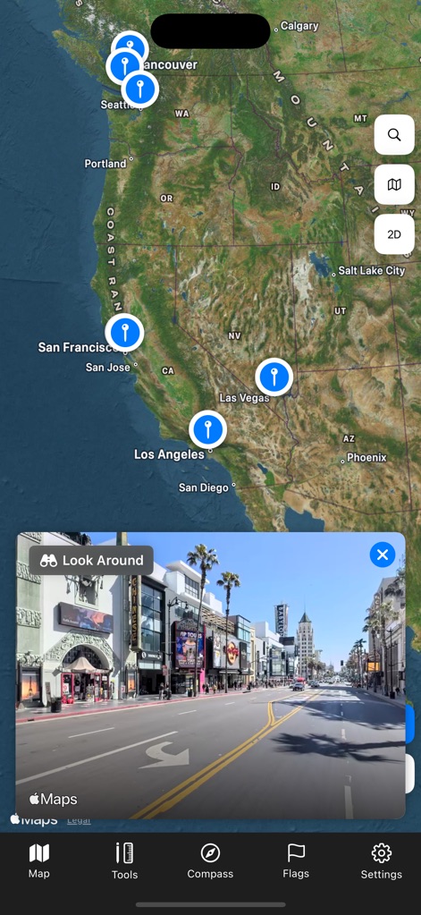
이 앱은 캘리포니아 및 워싱턴 등 서해안 주요 도시에 대한 여러 위치 핀과 함께 몰입형 스트리트 뷰로 활기찬 도시 거리를 생생하게 보여줍니다.
거리뷰와 지도
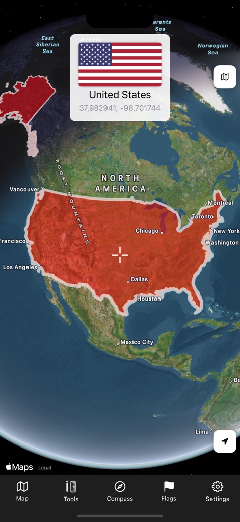
이 도구는 대화형 3D 지구본에 미국 국경선을 빨간색으로 강조하여 표시하며, 해당 국가의 국기 및 지리적 정보가 담긴 정보 카드를 제공합니다.
국가 경계 탐색
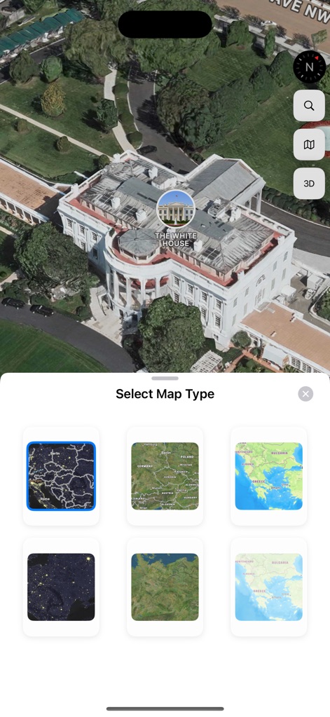
사용자는 웅장한 백악관과 같은 세계 명소를 정교한 3D 건물 모델로 탐색하고, 다양한 지도 유형 선택을 통해 야간 및 지형도를 포함한 여러 시각 스타일을 적용할 수 있습니다.
세계 명소 3D
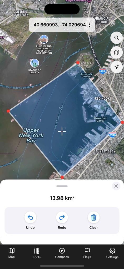
이 앱은 상부 뉴욕만의 면적을 나타내는 편집 가능한 다각형 도형과 함께 정확한 면적 측정 도구를 제공하여 지리적 영역을 쉽게 계산하고 조작할 수 있도록 합니다.
정확한 면적 계산
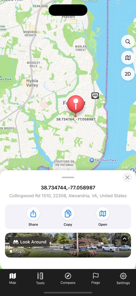
사용자는 지도상의 정확한 위치 핀을 통해 특정 좌표와 주소 정보를 확인하고, 이를 공유하거나 복사하는 옵션을 사용하여 쉽게 다른 사람과 정보를 주고받을 수 있습니다.
위치 정보 공유
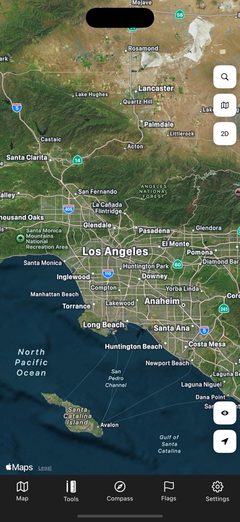
이 도구는 로스앤젤레스와 같은 주요 도시 및 롱비치와 같은 해안 지역의 이름을 명확히 표시하며, 산과 바다를 아우르는 상세한 지형 묘사를 제공합니다.
광범위한 지역 탐색
설명
Download
비슷한 앱
유사한 기능과 사용자 경험을 가진 앱

Earth Maps
FOXPOI PTE. LTD.

Satellite Map - Live Earth
慧敏 赵

World Street 3D Panoramic Map
Beijing Zhiyue Information Technology Co., Ltd

3D Earth Map Street View
Naik Ur Rehman

Globe 3D Earth: World Map Live
Shams Alam

Street View - street view maps
国辉 满

卫星地图-高清地球探索世界
方元 朱

GoGoEarth - Custom map source
大靖 刘

高清3D街景地图-地图软件手机全景版
Suzhou Caichuang Network Technology Co., Ltd.
이 페이지는 앱이나 개발자의 공식 페이지가 아니며, 정보 제공 및 논평을 목적으로 작성된 독립 편집 간행물입니다. 명시적으로 달리 언급되지 않는 한, 해당 앱이나 개발자는 MWM, Apple, Google Play, 앱 퍼블리셔 또는 앱 개발자와 제휴, 보증, 후원, 승인 또는 공식적으로 연결되어 있지 않으며, 이 페이지의 어떤 내용도 해당 앱이 MWM의 서비스를 사용하여 개발되었음을 의미하지 않습니다. 모든 상표, 로고, 스크린샷 및 기타 콘텐츠는 해당 소유자의 자산입니다.