이 페이지는 앱이나 개발자의 공식 페이지가 아니며, 정보 제공 및 논평을 목적으로 작성된 독립 편집 간행물입니다. 명시적으로 달리 언급되지 않는 한, 해당 앱이나 개발자는 MWM, Apple, Google Play, 앱 퍼블리셔 또는 앱 개발자와 제휴, 보증, 후원, 승인 또는 공식적으로 연결되어 있지 않으며, 이 페이지의 어떤 내용도 해당 앱이 MWM의 서비스를 사용하여 개발되었음을 의미하지 않습니다. 모든 상표, 로고, 스크린샷 및 기타 콘텐츠는 해당 소유자의 자산입니다.

GPS Geotag Map Camera - Tagofy
자동 GPS 스탬프, 맞춤 타임스탬프, 브랜드 로고로 모든 세부 정보를 캡처하세요. 부동산, 현장 작업 및 전 세계 모험 기록을 위한 최고의 도구입니다.
다운로드
418K+사용자 평점
총 평가 수
5K+개발사
카테고리
Photo & Video지원 언어
1최신 버전
3.5크기
190.8 MB출시일
2023년 8월 29일스마트 문서화, 풍부한 추억
현장이나 산봉우리에서든 고정밀 GPS 추적과 전문적인 브랜딩을 결합하여 전체 스토리를 담은 사진을 만드세요.
자동 정밀 지오태깅
정확한 주소, 좌표, 고도를 사진에 즉시 포함하여 절대적인 위치 정확성과 책임성을 확보하세요.
전문 맞춤 브랜딩
비즈니스 로고를 업로드하고 맞춤 프로젝트 노트를 추가하여 단순한 캡처를 검증된 전문 보고서로 변환하세요.
자주 묻는 질문
에 대해 알아야 할 모든 것 GPS Geotag Map Camera - Tagofy
GPS Geotag Map Camera - Tagofy 앱이란 무엇인가요?
GPS Geotag Map Camera - Tagofy 앱은 날짜와 시간, 지오태그, 위치 좌표, 날씨, 나침반 정보가 포함된 사진을 캡처합니다. 또한 이미지에 타임스탬프 워터마크를 추가합니다.
GPS Geotag Map Camera - Tagofy는 사진에 어떻게 위치를 추가하나요?
Tagofy는 앱 설치 및 사용자 정의 후 자동으로 스탬프를 삽입하여 사진에 GPS 위치를 추가합니다. 사용자는 스탬프를 선택하고 형식을 조정한 다음 앱 내에서 사진을 촬영합니다.
GPS Geotag Map Camera - Tagofy 앱에서 워터마크를 사용자 정의할 수 있나요?
네, GPS Geotag Map Camera - Tagofy 앱에서 워터마크를 사용자 정의할 수 있습니다. 옵션에는 워터마크 토글, 로고 사용자 정의, 개인화를 위한 사용자 정의 텍스트 추가가 포함됩니다.
GPS Geotag Map Camera - Tagofy는 동영상 녹화를 지원하나요?
네, GPS Geotag Map Camera - Tagofy는 고품질 동영상 캡처를 지원합니다. 사용자는 품질과 비트 전송률을 조정하고 MOV 및 MP4 형식 중에서 선택하며 안정화 기능으로 타임랩스 동영상을 녹화할 수 있습니다.
GPS Geotag Map Camera - Tagofy는 사진에 어떤 종류의 정보를 포함할 수 있나요?
Tagofy는 날짜 및 시간, 지오태그, 위도, 경도, 고도, 날씨, 자기장, 타임스탬프, 나침반 정보를 포함할 수 있습니다. 사용자는 사진에 주소, 메모, 로고, 해시태그를 추가할 수도 있습니다.
GPS Geotag Map Camera - Tagofy 앱은 지오태그가 지정된 사진에 대한 창의적인 템플릿을 제공하나요?
네, GPS Geotag Map Camera - Tagofy 앱은 지오태그가 지정된 사진에 대한 창의적인 템플릿을 제공합니다. 이러한 템플릿은 스탬프 세부 정보를 자동으로 가져와 이미지에 정보를 추가하는 과정을 단순화합니다.
GPS Geotag Map Camera - Tagofy를 사용하여 사진에 사용자 정의 브랜드 로고를 추가할 수 있나요?
네, 사용자는 GPS Geotag Map Camera - Tagofy 앱에서 자신의 브랜드 로고를 업로드하여 사진을 개인화할 수 있습니다. 이 기능은 고급 템플릿 섹션 설정에서 액세스할 수 있습니다.
GPS Geotag Map Camera - Tagofy에는 어떤 사용자 정의 카메라 옵션을 사용할 수 있나요?
Tagofy의 사용자 정의 GPS 카메라는 다양한 사진 요구를 위해 그리드, 비율, 전면 및 셀카 카메라, 플래시, 초점, 미러, 타이머 및 캡처 사운드 지원 옵션을 포함합니다.
다음 스크린샷과 설명은 앱의 공식 스토어 목록에서 직접 가져온 것이며 앱 개발자의 자산입니다.
앱 스토어
스크린샷
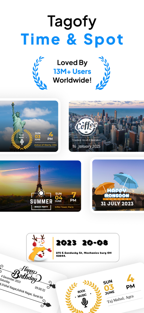
Tagofy GPS 지오태그 지도 카메라 앱의 위치 및 시간 스탬프가 있는 여행 사진 콜라주.
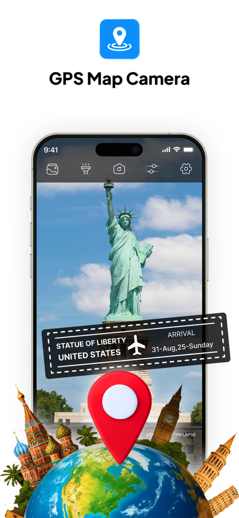
자유의 여신상 사진에 위치 및 날짜 스탬프가 있는 GPS 지도 카메라 앱 인터페이스
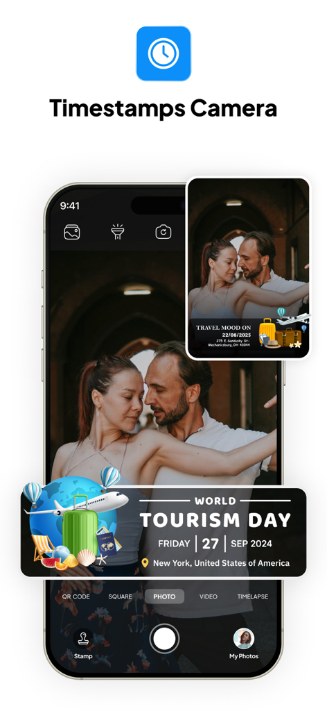
뉴욕에서 열리는 세계 관광의 날 GPS 지오태그 스탬프가 있는 사진의 Tagofy 앱 인터페이스
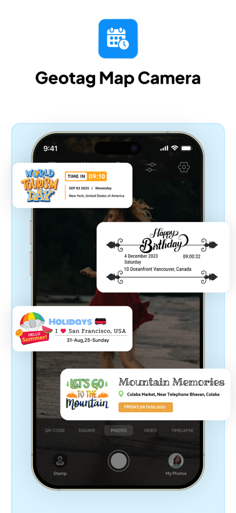
GPS 위치 데이터가 있는 여행 및 이벤트용 맞춤 사진 스탬프를 보여주는 Tagofy 앱 인터페이스
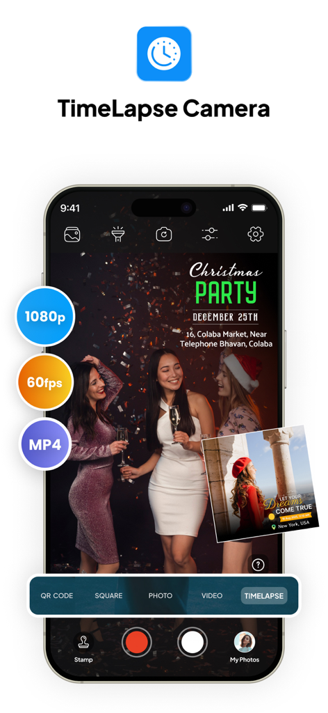
1080p 및 60fps 설정이 있는 타임랩스 카메라 모드를 보여주는 Tagofy 앱 인터페이스
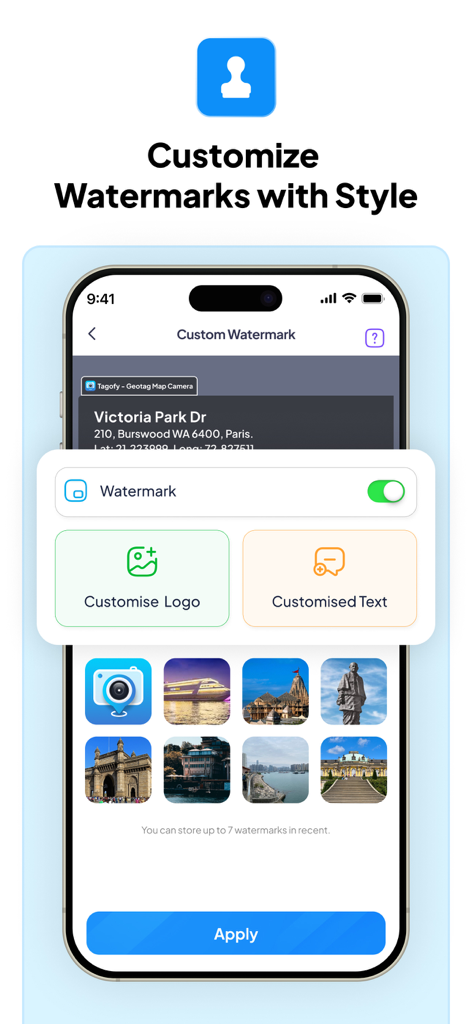
맞춤 로고 및 텍스트 옵션이 있는 Tagofy 앱 워터마크 사용자 지정 메뉴를 보여주는 스마트폰 화면
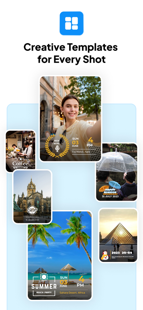
GPS 지오태그 및 타임스탬프용 창의적인 사진 템플릿 모음
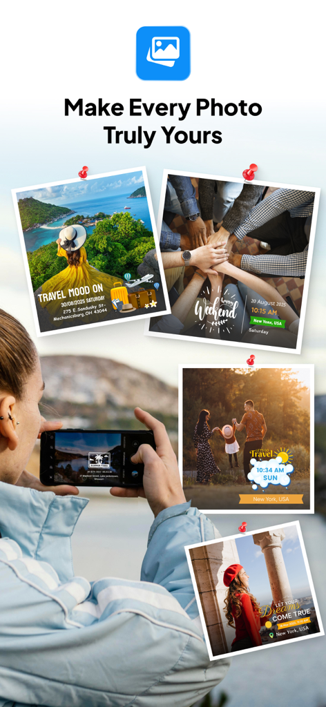
Tagofy 앱의 맞춤형 GPS 위치 및 날짜 스탬프가 있는 여행 사진 콜라주
설명
Download
비슷한 앱
유사한 기능과 사용자 경험을 가진 앱

Timestamp Camera -AI Timestamp
Shanghai Zongchong Information Technology Co., Ltd

Timestamp Camera - Date Stamp
Artify Inc.

Timestamp Camera: Time & GPS
Practical Apps from Sweden AB

Timestamp camera - gps cam
Guangzhou Siyue Network Technology Co., Ltd.

DateStamper
Jordan Hipwell

Timestamp Camera Basic
玉彬 陈

GPS Map Camera : Geo Photos
Chirag Gabani

Timestamp Camera: Time stamp
燕倩 费

Timestamp Camera - Time & GPS
Shaanxi Ruidebao Technology Co.,Ltd
이 페이지는 앱이나 개발자의 공식 페이지가 아니며, 정보 제공 및 논평을 목적으로 작성된 독립 편집 간행물입니다. 명시적으로 달리 언급되지 않는 한, 해당 앱이나 개발자는 MWM, Apple, Google Play, 앱 퍼블리셔 또는 앱 개발자와 제휴, 보증, 후원, 승인 또는 공식적으로 연결되어 있지 않으며, 이 페이지의 어떤 내용도 해당 앱이 MWM의 서비스를 사용하여 개발되었음을 의미하지 않습니다. 모든 상표, 로고, 스크린샷 및 기타 콘텐츠는 해당 소유자의 자산입니다.