이 페이지는 앱이나 개발자의 공식 페이지가 아니며, 정보 제공 및 논평을 목적으로 작성된 독립 편집 간행물입니다. 명시적으로 달리 언급되지 않는 한, 해당 앱이나 개발자는 MWM, Apple, Google Play, 앱 퍼블리셔 또는 앱 개발자와 제휴, 보증, 후원, 승인 또는 공식적으로 연결되어 있지 않으며, 이 페이지의 어떤 내용도 해당 앱이 MWM의 서비스를 사용하여 개발되었음을 의미하지 않습니다. 모든 상표, 로고, 스크린샷 및 기타 콘텐츠는 해당 소유자의 자산입니다.

GPS Map Camera Lite: Timestamp
사진에 담긴 모든 픽셀에 완벽한 진실을 새겨 넣습니다. 이 앱은 당신의 시야를 흔들림 없는 증거로 만듭니다.
다운로드
500k+사용자 평점
총 평가 수
2.0K개발사
카테고리
Photo & Video지원 언어
10최신 버전
1.4.15크기
48.0 MB출시일
2020년 5월 16일위치 기반 사진 기록 및 관리의 핵심 기능 평가
GPS Map Camera Lite: Timestamp 앱 분석
자동 위치 및 시간 스탬프
이 앱은 촬영된 모든 사진에 위치, 날짜, 시간을 자동으로 기록하여 사용자가 중요한 순간을 정확하게 문서화할 수 있도록 지원합니다.
사진 기반 위치별 정리
이 앱은 사진에 포함된 위치 데이터를 기반으로 사진을 쉽게 정리하고 검색할 수 있도록 지원하여, 특정 장소에서 찍은 사진을 빠르게 찾을 수 있게 합니다.
맞춤형 스탬프 및 데이터
사용자는 날짜 및 시간 형식, GPS 좌표, 메모, 로고, 워터마크 등을 포함한 스탬프 정보를 자신의 필요에 맞게 설정할 수 있습니다.
정확한 GPS 좌표 스탬프
이 앱은 촬영된 사진에 정확한 GPS 좌표를 직접 삽입하여, 위치의 정밀한 기록과 검증을 가능하게 합니다.
사진에 메모, 로고 및 워터마크 추가
사용자는 사진에 추가적인 메모, 개인 또는 회사 로고, 워터마크를 삽입하여 사진의 정보 가치를 높이고 저작권을 보호할 수 있습니다.
나침반 방향 표시
이 도구는 사진을 찍을 때 카메라 화면과 결과 사진에 나침반 방향을 표시하여, 사용자가 사진이 촬영된 정확한 방위를 알 수 있도록 돕습니다.
맞춤형 파일명 설정
사용자는 촬영된 사진 파일의 이름을 사용자 정의하여, 사진 관리 및 정리를 더욱 효율적으로 수행할 수 있습니다.
측정 단위 지원
이 도구는 미터법과 야드파운드법 단위를 모두 지원하여, 사용자가 선호하는 측정 시스템으로 위치 데이터를 확인할 수 있도록 합니다.
자주 묻는 질문
에 대해 알아야 할 모든 것 GPS Map Camera Lite: Timestamp
What is GPS Map Camera Lite: Timestamp?
GPS Map Camera Lite: Timestamp is a camera app that automatically embeds precise location, date, time, and other details directly onto photos and videos. It helps organize and verify captured moments.
Does GPS Map Camera Lite: Timestamp record video with location?
Yes, GPS Map Camera Lite: Timestamp records video with embedded location and timestamp details. This feature provides a complete record for documenting events and projects.
How does GPS Map Camera Lite: Timestamp add location to photos?
GPS Map Camera Lite: Timestamp adds location by using GPS for precise tracking. Users install the app, turn on GPS, customize stamps, and then capture photos or videos.
Can users customize date and time formats in GPS Map Camera Lite: Timestamp?
Yes, GPS Map Camera Lite: Timestamp allows users to customize date and time formats. The app also supports customizing units and other stamp details for personalized photo information.
What details can GPS Map Camera Lite: Timestamp embed on photos?
GPS Map Camera Lite: Timestamp can embed location, date, time, compass display, GPS coordinates, custom notes, logos, and watermarks onto photos. It also supports metric and imperial units.
Is GPS Map Camera Lite: Timestamp useful for real estate professionals?
Yes, GPS Map Camera Lite: Timestamp is perfect for real estate professionals. It helps them capture property photos with precise location details, ensuring accurate documentation and verification.
Can I add a custom note to photos using GPS Map Camera Lite: Timestamp?
Yes, GPS Map Camera Lite: Timestamp allows users to add custom notes to their photos. This feature helps provide additional context or descriptions for each captured moment.
Does GPS Map Camera Lite: Timestamp support different GPS coordinate formats?
Yes, GPS Map Camera Lite: Timestamp supports multiple GPS coordinate formats. Users can select options like Decimal, Deg Mins Secs, Dec Mins, UTM, and MGRS in the settings menu.
Can I use GPS Map Camera Lite: Timestamp for construction site documentation?
Yes, GPS Map Camera Lite: Timestamp is suitable for construction and inspection teams. It documents site progress and reports by capturing verifiable, location-tagged photos and videos.
Does GPS Map Camera Lite: Timestamp allow custom file naming?
Yes, GPS Map Camera Lite: Timestamp includes custom file naming options. Users can incorporate elements like notes, date, time, address, altitude, and coordinates into the file name.
다음 스크린샷과 설명은 앱의 공식 스토어 목록에서 직접 가져온 것이며 앱 개발자의 자산입니다.
앱 스토어
스크린샷
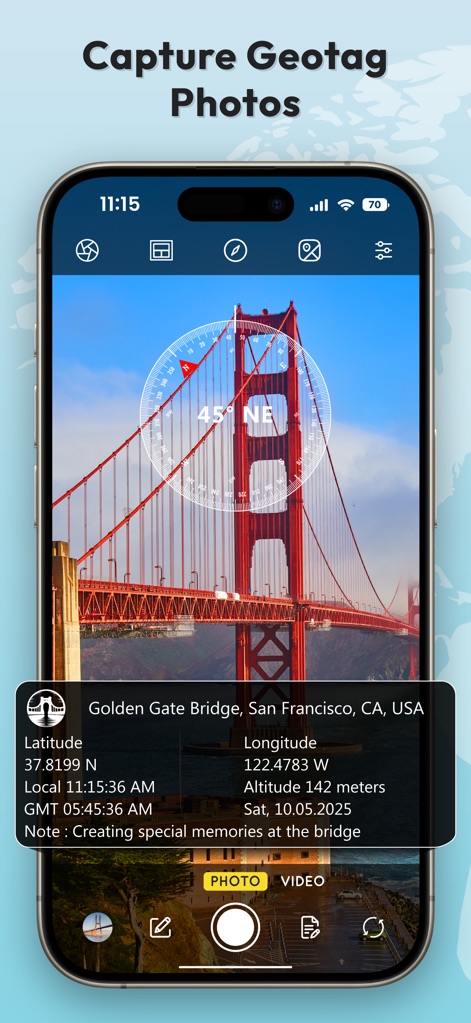
이 앱은 사진에 정확한 위치 데이터와 나침반 방향을 자동으로 표시하여, 사용자가 골든 게이트 브리지와 같은 명소의 순간을 상세히 기록할 수 있도록 돕습니다.
지리 태그 사진 캡처
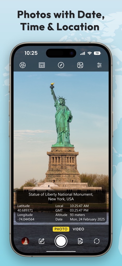
이 앱은 촬영된 이미지에 날짜와 시간을 자동 기록하며, 자유의 여신상과 같은 상징적인 랜드마크의 정확한 경도 및 위도 정보를 함께 제공합니다.
날짜, 시간, 위치 사진
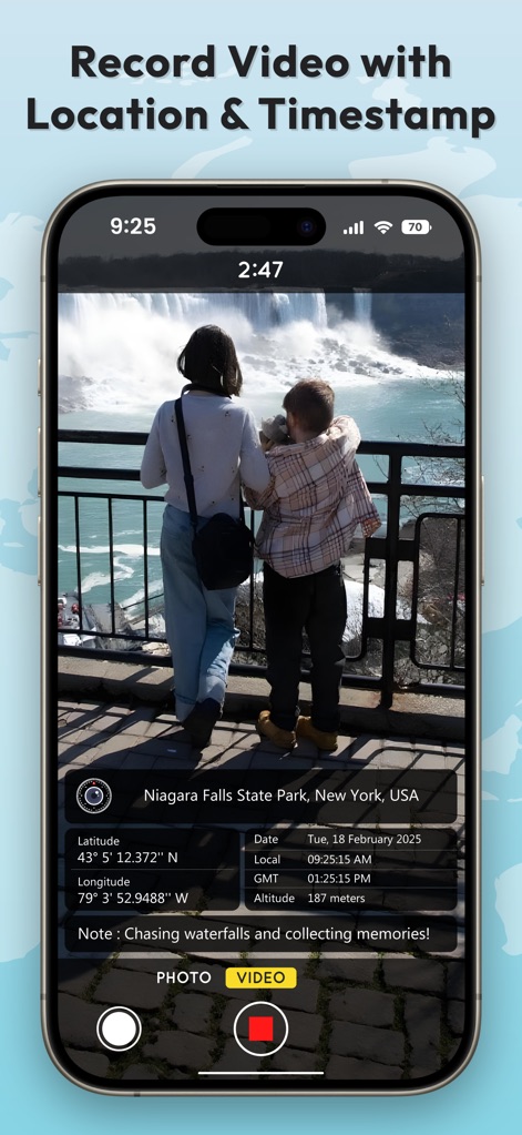
사용자는 비디오를 녹화하면서 나이아가라 폭포와 같은 장소의 실시간 GPS 좌표와 함께 촬영 시간 및 날짜를 영상에 명확히 기록할 수 있습니다.
위치, 타임스탬프 비디오
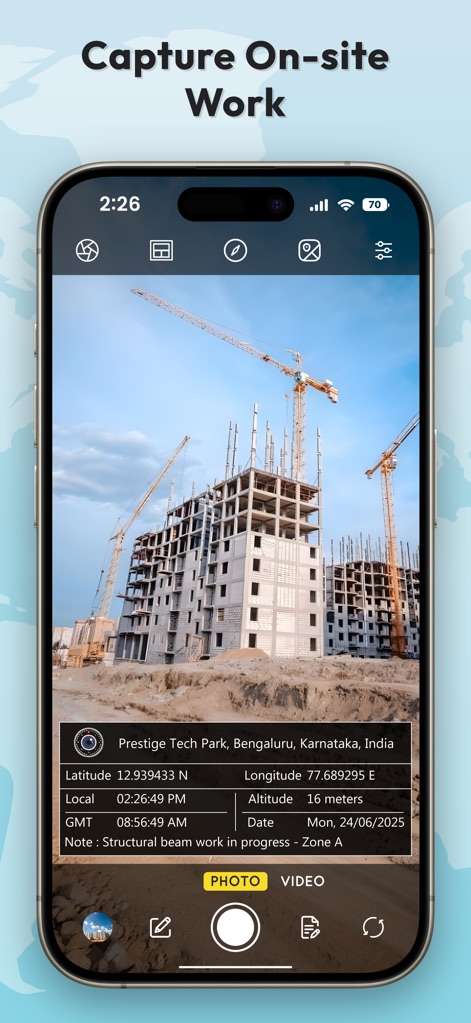
이 도구는 건설 현장과 같은 작업 환경에서 촬영된 사진에 정확한 위치 주소와 고도 데이터를 포함하여, 현장 작업 기록의 신뢰성을 높여줍니다.
현장 작업 기록

사용자는 파일 이름에 메모, 날짜, 시간 또는 주소를 포함하도록 사용자 정의할 수 있어, 사진 관리를 간편하게 만들고 조직화를 향상시킵니다.
자동 파일 이름 설정

이 앱은 사용자가 날짜 형식과 시간 형식을 포함하여 스탬프의 표시 방식을 개인의 선호에 맞게 세밀하게 조정할 수 있도록 합니다.
사용자 지정 형식 설정

이 앱은 여러 가지 시각적 스탬프 템플릿을 제공하여, 사용자가 로키 릿지 서밋이나 인도 구자라트와 같은 다양한 환경에 맞춰 정보를 표시하고 기록할 수 있습니다.
다양한 스탬프 템플릿

사용자는 십진수, 도분초(Deg Mins Secs) 또는 UTM과 같은 다양한 형식으로 GPS 좌표를 수동으로 선택하고 표시 방식을 사용자 정의할 수 있습니다.
수동 좌표 선택

이 앱은 건설 현장 측정 및 인도의 상징적인 랜드마크 사진에 위치, 시간, 고도 정보를 포함하는 다채로운 스탬프 스타일을 제공하여, 전문성과 심미성을 동시에 만족시킵니다.
다채로운 스탬프 스타일
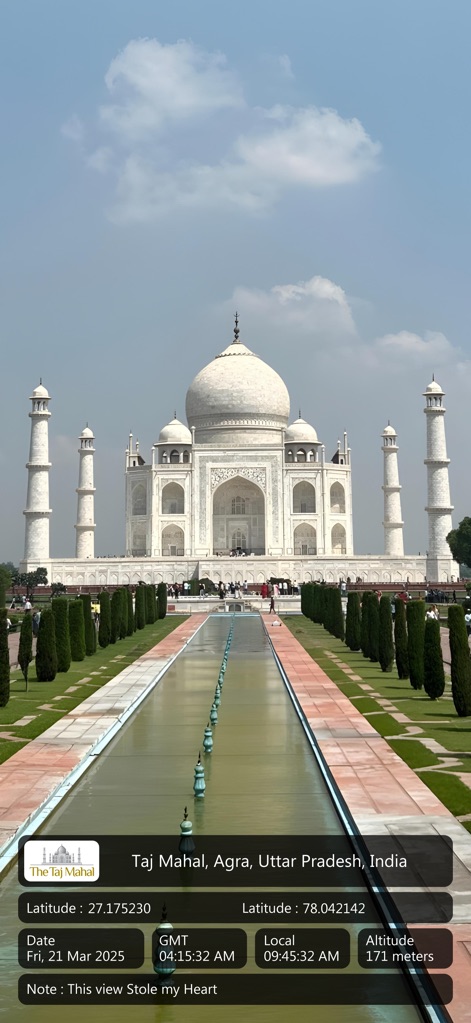
사용자는 타지마할과 같은 명소의 사진에 위도와 경도 같은 정확한 위치 정보와 함께 개인적인 메모를 추가하여 특별한 순간을 기록할 수 있습니다.
상세한 위치 기록
설명
Download
비슷한 앱
유사한 기능과 사용자 경험을 가진 앱

Timestamp Camera -AI Timestamp
Shanghai Zongchong Information Technology Co., Ltd

Timestamp Camera - Date Stamp
Artify Inc.

Timestamp Camera: Time & GPS
Practical Apps from Sweden AB

Timestamp camera - gps cam
Guangzhou Siyue Network Technology Co., Ltd.

DateStamper
Jordan Hipwell

Timestamp Camera Basic
玉彬 陈

GPS Map Camera : Geo Photos
Chirag Gabani

Timestamp Camera: Time stamp
燕倩 费

Timestamp Camera - Time & GPS
Shaanxi Ruidebao Technology Co.,Ltd
이 페이지는 앱이나 개발자의 공식 페이지가 아니며, 정보 제공 및 논평을 목적으로 작성된 독립 편집 간행물입니다. 명시적으로 달리 언급되지 않는 한, 해당 앱이나 개발자는 MWM, Apple, Google Play, 앱 퍼블리셔 또는 앱 개발자와 제휴, 보증, 후원, 승인 또는 공식적으로 연결되어 있지 않으며, 이 페이지의 어떤 내용도 해당 앱이 MWM의 서비스를 사용하여 개발되었음을 의미하지 않습니다. 모든 상표, 로고, 스크린샷 및 기타 콘텐츠는 해당 소유자의 자산입니다.