이 페이지는 앱이나 개발자의 공식 페이지가 아니며, 정보 제공 및 논평을 목적으로 작성된 독립 편집 간행물입니다. 명시적으로 달리 언급되지 않는 한, 해당 앱이나 개발자는 MWM, Apple, Google Play, 앱 퍼블리셔 또는 앱 개발자와 제휴, 보증, 후원, 승인 또는 공식적으로 연결되어 있지 않으며, 이 페이지의 어떤 내용도 해당 앱이 MWM의 서비스를 사용하여 개발되었음을 의미하지 않습니다. 모든 상표, 로고, 스크린샷 및 기타 콘텐츠는 해당 소유자의 자산입니다.

GPS Maps Camera
당신의 사진에 시공간의 흔적을 각인한다. 이 앱은 단순한 스냅샷을 강력한 데이터 증거로 변환시키는 도구이다.
다운로드
750k+사용자 평점
총 평가 수
92개발사
카테고리
Navigation지원 언어
21최신 버전
2.0크기
35.2 MB출시일
2024년 7월 17일GPS Maps Camera 앱의 핵심 기능을 분석하고, 사용자에게 제공하는 주요 이점을 평가합니다.
GPS Maps Camera: 상세한 지리 정보 기록을 위한 테크 분석
정밀한 위치 정보 오버레이
이 앱은 GPS 좌표(십진법, MGRS, UTM), 주소 형식 및 수동/현재 위치 데이터를 사진에 정확하게 오버레이하여 상세한 지리적 위치 정보를 제공합니다.
환경 데이터 자동 기록
이 도구는 온도, 풍속, 나침반 방향, 자기장, 기압 및 고도와 같은 실시간 환경 데이터를 자동으로 측정하여 사진에 표시할 수 있습니다.
사용자 정의 템플릿 및 정보 배열
이 도구는 사용자가 다양한 템플릿을 선택하고 필요한 형식에 따라 지도, 좌표, 날씨 등 정보를 사진에 유연하게 배열할 수 있도록 합니다.
지도 데이터 통합 및 유형 선택
사용자가 사진에 상세한 지도 데이터를 수동 또는 자동으로 포함할 수 있으며, 일반, 위성, 하이브리드 보기와 같은 다양한 지도 유형을 선택할 수 있도록 합니다.
유연한 날짜 및 시간 스탬프
이 앱은 다양한 형식과 사용자 지정 시간대로 날짜 및 시간을 사진에 정확하게 기록하여 문서화 및 시간적 정확성을 보장합니다.
정보 표시 맞춤 설정
사용자가 사진에 표시되는 정보(예: 지도, 날씨, 좌표)를 자유롭게 숨기거나 표시할 수 있도록 하여 원하는 정보만 강조하거나 불필요한 정보를 제거할 수 있습니다.
맞춤형 카메라 제어
사용자가 그리드, 종횡비, 플래시, 초점 및 타이머와 같은 다양한 카메라 설정을 조정하여 촬영 경험을 최적화하고 원하는 구도를 얻을 수 있습니다.
사진 관리 및 공유
이 앱은 스탬프가 찍힌 사진을 쉽게 캡처하고, 갤러리에 저장하며, 불필요한 사진을 삭제하고, 다양한 플랫폼을 통해 공유할 수 있도록 합니다.
자주 묻는 질문
에 대해 알아야 할 모든 것 GPS Maps Camera
What is the GPS Maps Camera app?
The GPS Maps Camera app captures and customizes photos with detailed map data, weather conditions, and various informational stamps. It is designed for photographers, travelers, and outdoor enthusiasts.
Can I manually add GPS coordinates to photos using GPS Maps Camera?
Yes, the GPS Maps Camera app allows users to manually set GPS coordinates and location data for their photos. This feature is available in the Map Data section of the app.
What customization options does the GPS Maps Camera app offer for templates?
The GPS Maps Camera app offers various template customization options, including different map types, address formats, GPS coordinate formats (Decimal, MGRS, UTM), date/time formats, and weather information units.
Does GPS Maps Camera display weather information on photo stamps?
Yes, the GPS Maps Camera app displays weather information directly on photo stamps. Users can choose to show temperature in Fahrenheit or Celsius and wind speed in their preferred units.
How can I manage my photos within the GPS Maps Camera app?
After capturing images with a stamp, the GPS Maps Camera app allows users to easily delete, share, or save photos to their gallery. It also includes a QR code scanning feature.
What are the subscription terms for the GPS Maps Camera app?
The GPS Maps Camera app subscription automatically renews unless turned off 24 hours before the period ends. Payment is charged to the iTunes Account, and no cancellation is allowed during an active subscription.
Can I choose different map views in the GPS Maps Camera templates?
Yes, the GPS Maps Camera app allows users to switch between Normal, Satellite, and Hybrid map views within the advanced template options. This enhances the visual context of geotagged photos.
Does the GPS Maps Camera app automatically calculate altitude and accuracy?
Yes, the GPS Maps Camera app automatically calculates and displays altitude. It also provides accuracy details in two formats, ensuring precise geotagging information for your captured images.
다음 스크린샷과 설명은 앱의 공식 스토어 목록에서 직접 가져온 것이며 앱 개발자의 자산입니다.
앱 스토어
스크린샷
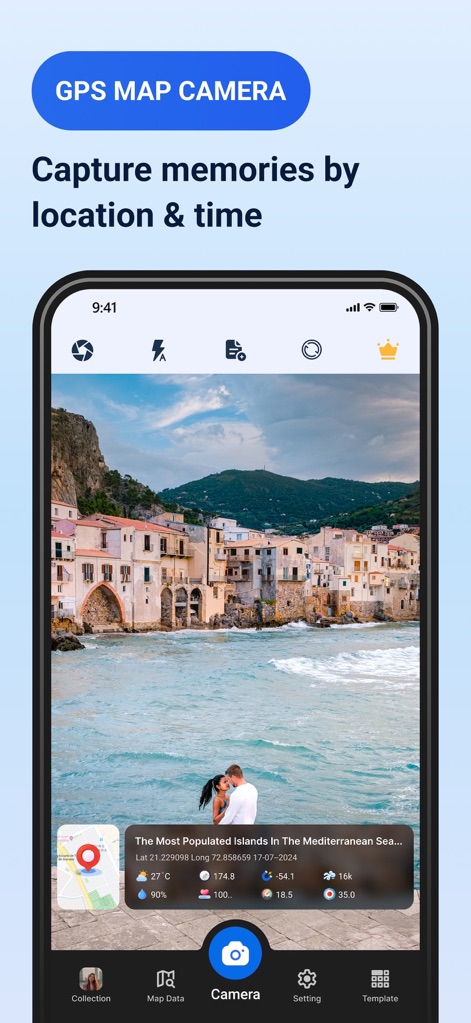
이 앱은 촬영된 사진 하단에 정확한 위치 좌표와 상세한 시간 정보를 함께 표시합니다.
위치 시간 스탬프
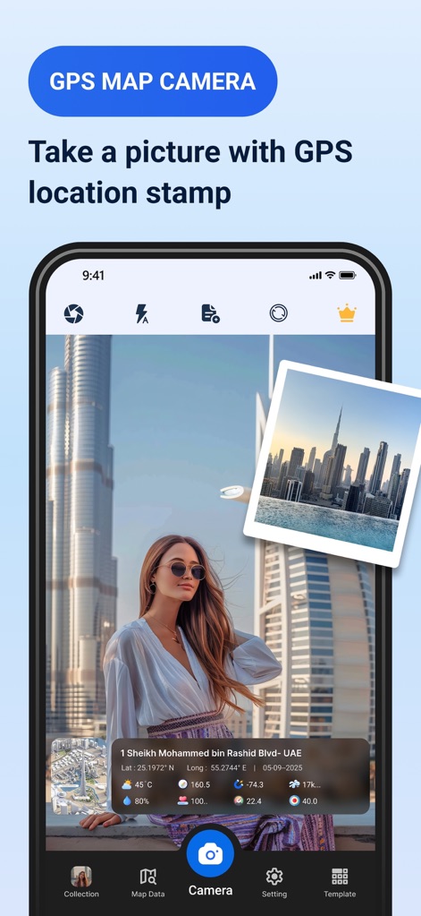
사용자는 사진에 GPS 위치 스탬프를 추가하여 도시 이름과 함께 현재 온도 데이터를 확인할 수 있습니다.
GPS 사진 기록
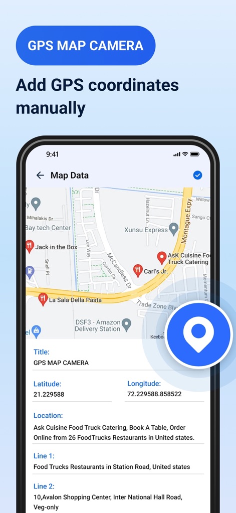
이 도구는 지도 인터페이스를 통해 원하는 위치를 선택하거나 위도 및 경도 값을 수동으로 입력할 수 있게 합니다.
수동 위치 지정
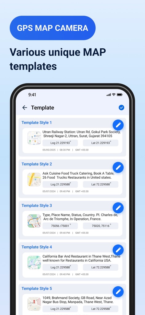
앱은 여러 가지 맵 데이터 템플릿 스타일을 제공하며, 각 템플릿의 지도 유형과 날짜 형식 설정을 편집할 수 있습니다.
다양한 템플릿 편집
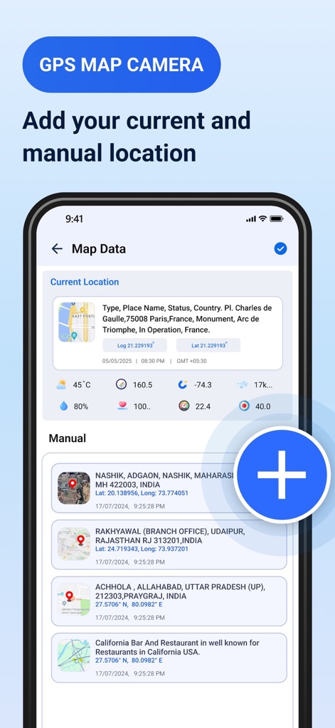
사용자는 현재 위치 정보를 자동으로 확인하거나, 이전에 추가한 여러 수동 위치 데이터를 목록에서 관리할 수 있습니다.
위치 데이터 목록
설명
Download
비슷한 앱
유사한 기능과 사용자 경험을 가진 앱

Timestamp Camera -AI Timestamp
Shanghai Zongchong Information Technology Co., Ltd

Timestamp Camera - Date Stamp
Artify Inc.

Timestamp Camera: Time & GPS
Practical Apps from Sweden AB

Timestamp camera - gps cam
Guangzhou Siyue Network Technology Co., Ltd.

DateStamper
Jordan Hipwell

Timestamp Camera Basic
玉彬 陈

GPS Map Camera : Geo Photos
Chirag Gabani

Timestamp Camera: Time stamp
燕倩 费

Timestamp Camera - Time & GPS
Shaanxi Ruidebao Technology Co.,Ltd
이 페이지는 앱이나 개발자의 공식 페이지가 아니며, 정보 제공 및 논평을 목적으로 작성된 독립 편집 간행물입니다. 명시적으로 달리 언급되지 않는 한, 해당 앱이나 개발자는 MWM, Apple, Google Play, 앱 퍼블리셔 또는 앱 개발자와 제휴, 보증, 후원, 승인 또는 공식적으로 연결되어 있지 않으며, 이 페이지의 어떤 내용도 해당 앱이 MWM의 서비스를 사용하여 개발되었음을 의미하지 않습니다. 모든 상표, 로고, 스크린샷 및 기타 콘텐츠는 해당 소유자의 자산입니다.