이 페이지는 앱이나 개발자의 공식 페이지가 아니며, 정보 제공 및 논평을 목적으로 작성된 독립 편집 간행물입니다. 명시적으로 달리 언급되지 않는 한, 해당 앱이나 개발자는 MWM, Apple, Google Play, 앱 퍼블리셔 또는 앱 개발자와 제휴, 보증, 후원, 승인 또는 공식적으로 연결되어 있지 않으며, 이 페이지의 어떤 내용도 해당 앱이 MWM의 서비스를 사용하여 개발되었음을 의미하지 않습니다. 모든 상표, 로고, 스크린샷 및 기타 콘텐츠는 해당 소유자의 자산입니다.

Live Satellite View & GPS Maps
실시간 위성 영상, 정확한 GPS 추적, 오프라인 내비게이션으로 세상을 손안에 담으세요. 외딴 하이킹 트레일을 찾거나 부동산 경계를 분석하는 데 이르기까지, 시각적 계획가를 위해 설계된 전문적인 수준의 지도 레이어와 과거 기록을 경험해 보세요.
다운로드
94K+사용자 평점
총 평가 수
1K+개발사
카테고리
Navigation지원 언어
1최신 버전
1.0.7크기
89.9 MB출시일
2024년 12월 23일최고 수준의 디테일로 위에서 세상을 탐험하세요
외딴 하이킹 트레일을 찾거나 부동산 경계를 검사하는 것까지, 고해상도 영상과 신뢰할 수 있는 GPS 도구로 최고의 조감도를 얻으세요.
초고화질 위성 보기
진정한 세상의 모습을 보세요. 고해상도 영상을 사용하여 지형을 조사하고, 부동산 풍경을 분석하거나, 수정처럼 맑은 상태로 외딴 지역을 탐험하세요.
오프라인 GPS 내비게이션
야외 모험 중에 안전을 유지하세요. 오프라인 사용을 위해 지도를 다운로드하고 휴대폰 서비스 지역을 벗어난 곳에서도 실시간으로 정확한 위치를 추적하세요.
자주 묻는 질문
에 대해 알아야 할 모든 것 Live Satellite View & GPS Maps
Live Satellite View & GPS Maps 앱의 주요 기능은 무엇인가요?
Live Satellite View & GPS Maps 앱은 고해상도 위성 이미지와 실시간 GPS 추적 기능을 제공합니다. 사용자는 대화형 지도와 내비게이션 기능을 사용하여 우주에서 지구상의 모든 장소를 탐색할 수 있습니다.
Live Satellite View & GPS Maps는 실시간 위성 이미지를 제공하나요?
예, Live Satellite View & GPS Maps는 전 세계 모든 장소에 대한 최신 위성 이미지에 액세스할 수 있습니다. 이를 통해 지구를 탐색하는 데 생생하고 고해상도의 세부 정보를 제공합니다.
Live Satellite View & GPS Maps 앱으로 제 위치를 추적할 수 있나요?
예, Live Satellite View & GPS Maps에는 실시간 GPS 추적 기능이 포함되어 있습니다. 사용자는 이 기능을 사용하여 정확한 위치를 파악하고, 경로를 계획하고, 주변 장소를 찾을 수 있습니다.
Live Satellite View & GPS Maps에는 어떤 종류의 지도 보기가 있나요?
Live Satellite View & GPS Maps는 위성, 지형, 혼합 옵션을 포함한 대화형 지도 보기를 제공합니다. 사용자는 내비게이션 및 탐색을 위해 이러한 보기 간을 원활하게 전환할 수 있습니다.
Live Satellite View & GPS Maps에 오프라인 모드가 있나요?
예, Live Satellite View & GPS Maps에는 오프라인 모드가 있습니다. 사용자는 인터넷 연결 없이도 위성 이미지에 액세스하기 위해 특정 지역을 다운로드할 수 있습니다.
Live Satellite View & GPS Maps 앱에 스트리트 뷰 기능이 포함되어 있나요?
예, Live Satellite View & GPS Maps 앱에는 스트리트 뷰 기능이 포함되어 있습니다. 사용자는 다양한 국가 및 장소의 거리 수준 보기를 찾아 탐색할 수 있습니다.
Live Satellite View & GPS Maps로 주변 장소를 어떻게 찾을 수 있나요?
Live Satellite View & GPS Maps는 "주변 장소" 기능을 제공합니다. 사용자는 병원, 레스토랑, ATM, 학교 등 다양한 카테고리를 검색할 수 있습니다.
Live Satellite View & GPS Maps는 교통 정보를 표시하나요?
예, Live Satellite View & GPS Maps에는 "교통" 기능이 포함되어 있습니다. 일반, 느림, 매우 느림, 심각한 교통 상황을 표시하는 교통 추적 기능을 제공합니다.
Live Satellite View & GPS Maps는 속도계로 작동하나요?
예, Live Satellite View & GPS Maps에는 "속도계" 기능이 포함되어 있습니다. 현재 속도(km/h), 평균 속도, 최대 속도, 시간 및 거리를 표시합니다.
Live Satellite View & GPS Maps 앱으로 거리를 측정할 수 있나요?
예, Live Satellite View & GPS Maps는 "면적 측정" 기능을 제공합니다. 사용자는 지도상의 지점을 선택하여 그 지점 간의 거리나 면적을 계산할 수 있습니다.
다음 스크린샷과 설명은 앱의 공식 스토어 목록에서 직접 가져온 것이며 앱 개발자의 자산입니다.
앱 스토어
스크린샷
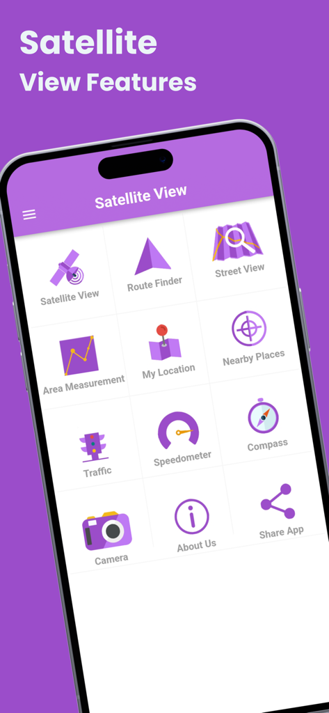
모바일 앱 메뉴에 위성 보기 경로 찾기, 스트리트 뷰, 면적 측정 아이콘을 포함한 내비게이션 도구가 표시되어 있습니다.
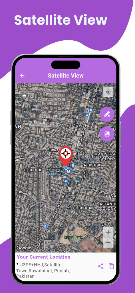
현재 위치를 나타내는 빨간색 핀과 함께 고해상도 위성 지도 보기를 보여주는 스마트폰
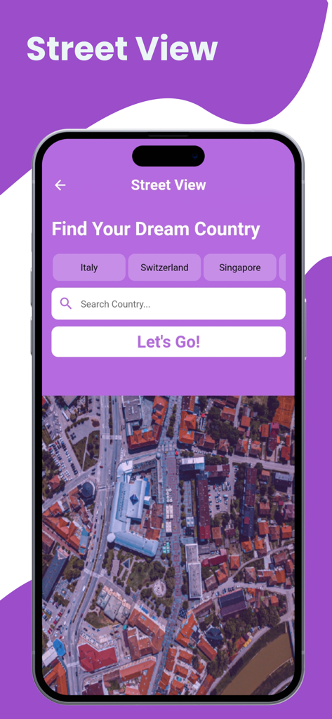
도시 지역의 위성 지도를 보여주는 실시간 위성 보기 및 GPS 지도 앱의 스트리트 뷰 검색 인터페이스
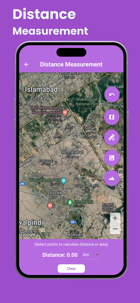
고해상도 위성 지도에서 거리 측정 도구를 표시하는 스마트폰
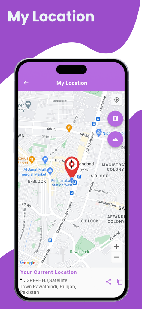
상세한 스트리트 지도에 사용자의 현재 위치를 빨간색 핀으로 표시하는 실시간 위성 보기 및 GPS 지도 앱
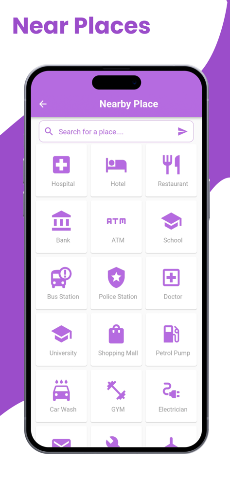
레스토랑 및 호텔과 같은 주변 장소의 다양한 범주를 표시하는 화면
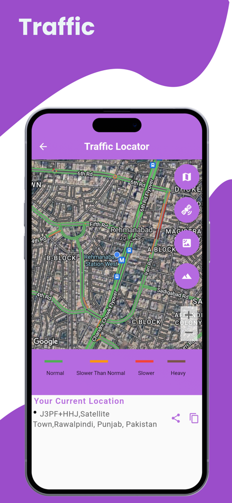
색상으로 구분된 도로 상태가 표시된 고해상도 위성 지도상의 실시간 교통 위치를 표시하는 모바일 앱 인터페이스
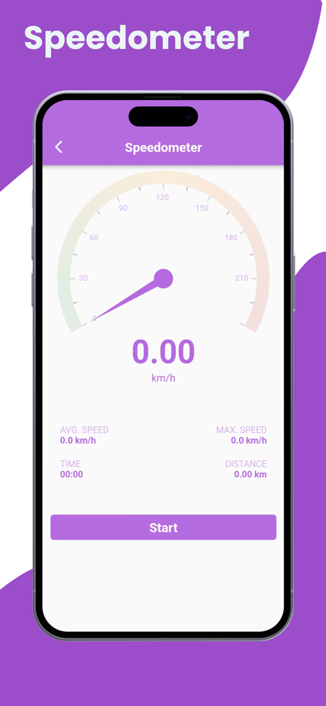
속도 및 거리 추적 기능을 보여주는 GPS 지도 앱의 디지털 속도계 인터페이스
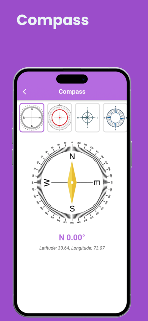
북쪽 방향과 GPS 좌표를 보여주는 디지털 나침반 인터페이스
설명
Download
비슷한 앱
유사한 기능과 사용자 경험을 가진 앱

Earth Maps
FOXPOI PTE. LTD.

Satellite Map - Live Earth
慧敏 赵

Satellite Map - Earth View
ANKAGIS YAZILIM ANONIM SIRKETI

World Street 3D Panoramic Map
Beijing Zhiyue Information Technology Co., Ltd

3D Earth Map Street View
Naik Ur Rehman

Globe 3D Earth: World Map Live
Shams Alam

Street View - street view maps
国辉 满

卫星地图-高清地球探索世界
方元 朱

GoGoEarth - Custom map source
大靖 刘
이 페이지는 앱이나 개발자의 공식 페이지가 아니며, 정보 제공 및 논평을 목적으로 작성된 독립 편집 간행물입니다. 명시적으로 달리 언급되지 않는 한, 해당 앱이나 개발자는 MWM, Apple, Google Play, 앱 퍼블리셔 또는 앱 개발자와 제휴, 보증, 후원, 승인 또는 공식적으로 연결되어 있지 않으며, 이 페이지의 어떤 내용도 해당 앱이 MWM의 서비스를 사용하여 개발되었음을 의미하지 않습니다. 모든 상표, 로고, 스크린샷 및 기타 콘텐츠는 해당 소유자의 자산입니다.