This page is not an official page of the app or its developer, but an independent editorial publication created for informational and commentary purposes. Unless expressly stated otherwise, neither the app nor its developer is affiliated with, endorsed by, sponsored by, authorized by, or otherwise officially connected with MWM, Apple, Google Play, the app publisher, or the app's developer, and nothing on this page implies that the app was developed using MWM's services. Any trademarks, logos, screenshots, and other content remain the property of their respective owners.

Earth Maps
Global clarity, pixel by pixel. This app delivers the planet's pulse, offering users unparalleled ground truth from orbit.
Downloads
1M+User Rating
Total Ratings
8.5KPublisher
Category
NavigationLocales
10Latest Version
1.2.01Size
73.2 MBFirst Released
Dec 1, 2022An evaluation of key functionalities for geospatial professionals and enthusiasts.
Earth Maps: Core Features Analysis
Precise Area & Distance Measurement
It allows users to accurately measure distances and calculate areas directly on the map, essential for planning, surveying, and property assessment.
Up-to-Date Satellite Imagery
This tool features the most recent satellite imagery, offering current views of global landscapes for up-to-the-minute analysis and monitoring.
Historical Street View Access
The app provides access to historical street-level imagery, crucial for timeline analysis, urban planning comparisons, and property evolution tracking.
High-Definition 3D Globe
The app provides a high-resolution, interactive 3D representation of Earth, enabling detailed terrain and structural visualization.
Custom Map Tile Integration
It allows users to load external map tile data, enhancing flexibility for specialized mapping projects or proprietary data overlays.
Integrated Orientation Compass
This tool features an integrated compass to assist with directional awareness and accurate navigation within the virtual environment.
Frequently Asked Questions
Everything you need to know about Earth Maps
What core features does the Earth Maps app offer?
Yes, Earth Maps provides a high-definition 3D globe with the latest satellite imagery. It allows users to view any place on Earth, including detailed terrain, buildings, and roads.
Can I view historical satellite imagery using Earth Maps?
Yes, Earth Maps allows users to view HD historical satellite imagery. This feature enables the comparison of different time periods, showcasing changes over decades, as depicted with dates like 1994 and 2023.
Does Earth Maps allow users to view locations in 3D terrain?
Yes, Earth Maps supports viewing detailed 3D terrain. The application provides an "Overlook 3D Terrain" feature, allowing users to explore mountainous and varied landscapes in a three-dimensional perspective.
Does the Earth Maps app offer a street view function?
Yes, Earth Maps includes a feature to explore 360° Street View. Users can navigate and observe street-level perspectives of various locations, offering an immersive virtual travel experience.
Can I measure area and distance within the Earth Maps application?
Yes, Earth Maps features a GIS Measurement Tool. Users can accurately measure perimeter and area directly within the app, providing precise geographical data for any selected region.
Does Earth Maps include a compass feature?
Yes, Earth Maps integrates an Oriental compass function. This feature assists users with navigation and orientation, helping them understand their bearing within the application's map views.
The following screenshots and description are sourced directly from the app's official store listing and are the property of the app developer.
App Store
Screenshots

This tool provides a dynamic historical comparison slider and precise date display, allowing users to analyze changes over time with high-definition satellite imagery.
Historical Imagery Comparison
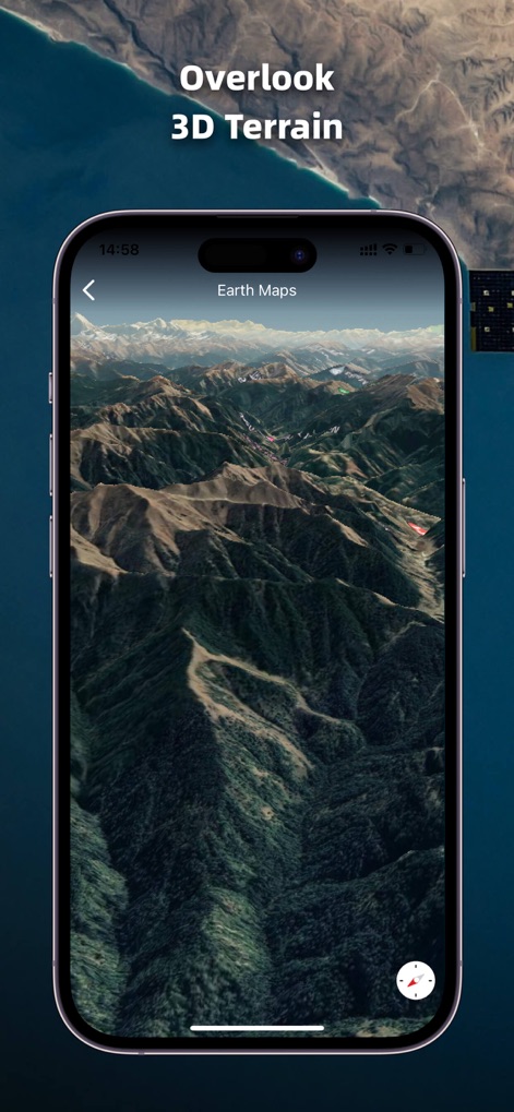
Explore the app's capability to render detailed 3D terrain and observe intricate elevation changes, offering an immersive perspective of the Earth's surface.
Immersive 3D Terrain

Discover the interactive 360° street view and utilize the historical timeline feature to revisit past street-level perspectives of any location.
Dynamic Street View

Leverage the advanced GIS measurement tools to accurately calculate area and instantly display perimeter details for any selected region on the map.
Precise Measurement Tools
Description
Download
More Like This
Apps with similar features and user experience

Satellite Map - Live Earth
慧敏 赵

Satellite Map - Earth View
ANKAGIS YAZILIM ANONIM SIRKETI

World Street 3D Panoramic Map
Beijing Zhiyue Information Technology Co., Ltd

3D Earth Map Street View
Naik Ur Rehman

Globe 3D Earth: World Map Live
Shams Alam

Street View - street view maps
国辉 满

卫星地图-高清地球探索世界
方元 朱

GoGoEarth - Custom map source
大靖 刘

高清3D街景地图-地图软件手机全景版
Suzhou Caichuang Network Technology Co., Ltd.
This page is not an official page of the app or its developer, but an independent editorial publication created for informational and commentary purposes. Unless expressly stated otherwise, neither the app nor its developer is affiliated with, endorsed by, sponsored by, authorized by, or otherwise officially connected with MWM, Apple, Google Play, the app publisher, or the app's developer, and nothing on this page implies that the app was developed using MWM's services. Any trademarks, logos, screenshots, and other content remain the property of their respective owners.