This page is not an official page of the app or its developer, but an independent editorial publication created for informational and commentary purposes. Unless expressly stated otherwise, neither the app nor its developer is affiliated with, endorsed by, sponsored by, authorized by, or otherwise officially connected with MWM, Apple, Google Play, the app publisher, or the app's developer, and nothing on this page implies that the app was developed using MWM's services. Any trademarks, logos, screenshots, and other content remain the property of their respective owners.

GOHUNT: Research & Maps
Hunting just got serious. This app turns raw data into your next trophy.
Downloads
250k+User Rating
Total Ratings
8.4KPublisher
Category
NavigationLocales
1Latest Version
12.0.0Size
302.1 MBFirst Released
May 3, 2021A detailed evaluation of key features driving strategic hunting success for dedicated users.
GOHUNT: Research & Maps - Core Functionality Assessment
Advanced Draw Odds Research & Filtering
The app provides users with advanced tools to research and filter hunt units based on criteria like draw odds, public land, and harvest success, crucial for strategic tag acquisition in Western states.
Extensive Customizable Map Layers
This tool features a rich array of customizable map layers, including species distribution, water sources, roads, elevation bands, and wildfire data, allowing for detailed environmental analysis and strategic planning.
Offline Mapping Capabilities
It allows users to download maps for offline use, ensuring critical navigation and spatial data are accessible even in remote areas without cellular service, vital for safety and continuity.
Integrated Hunt Unit & Zone Overlays
The app displays official hunt unit and zone boundaries directly on its maps, providing users with clear, critical information for legal compliance and precise targeting of hunting areas.
Detailed Public/Private Land Mapping
It provides comprehensive mapping of public and private land boundaries across all 50 states, which is essential for ethical hunting, legal compliance, and planning routes effectively.
Precise GPS Tracking
This tool offers highly accurate real-time GPS tracking, enabling users to navigate unfamiliar terrain, record their routes, and maintain safety during their hunts.
Advanced 3D Terrain & Analysis Tools
The app features sophisticated 3D terrain views and analysis tools, empowering users to gain a detailed topographical understanding of hunt areas for strategic positioning and movement planning.
Western States Point Tracker
It allows dedicated hunters to track their accumulated preference or bonus points for draws in Western states, a critical component of long-term tag acquisition strategies.
Historical Satellite Imagery Access
The app provides access to a library of historical satellite imagery, allowing users to identify past changes in habitat, water sources, or terrain, invaluable for pre-season scouting and predicting game patterns.
Comprehensive Western Unit Profiles
This tool offers detailed profiles for Western hunting units, including write-ups, historical data, and user insights, which aid in thoroughly researching and understanding potential hunting grounds.
Frequently Asked Questions
Everything you need to know about GOHUNT: Research & Maps
How does GOHUNT help users find hunting units?
GOHUNT's research platform helps users find units by selecting a state and species. They can filter results by draw odds, public land percentage, and historical harvest success, then view suitable units directly in the mapping platform.
Does GOHUNT provide maps for all 50 US states?
Yes, the GOHUNT mapping platform includes comprehensive map coverage for all 50 US states. It provides essential details such as public and private land boundaries, hunt units, and various environmental layers.
Can GOHUNT users share waypoints with others?
Yes, GOHUNT allows users to share waypoints, tracks, and entire hunts with other GOHUNT users. This feature enables collaboration and organization of hunting plans within the app.
Does GOHUNT offer a free trial?
Yes, GOHUNT offers a 7-day free trial upon signup. Users can access and try all the features of the application during this period before deciding on a subscription.
What mapping layers are available in the GOHUNT app?
GOHUNT offers various map layers including land ownership, government land, species distribution, roads and trails, elevation bands, water sources, and wildfire data. These layers enhance planning and navigation.
Can I use GOHUNT maps offline?
Yes, GOHUNT provides downloadable offline maps. This feature ensures users can navigate and access critical map information even in areas without cellular service or internet connectivity, facilitating remote hunts.
How can GOHUNT assist with hunt research and filtering?
GOHUNT offers advanced search and filtering tools for hunt research. Users can filter by draw odds, public land, and historical harvest success, find unit profiles, and access application strategies and deadlines.
Does GOHUNT track user movements?
Yes, GOHUNT includes accurate GPS tracking. Users can record and save their tracks, which displays detailed information such as distance, time, speed, and elevation of their movements during a hunt.
The following screenshots and description are sourced directly from the app's official store listing and are the property of the app developer.
App Store
Screenshots

This tool simplifies hunt planning, allowing users to select target species like 'Elk' and preferred weapon types such as a 'Bow' for personalized hunt preparation.
Tailored Hunt Planning
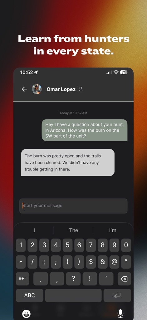
The app fosters collaboration, enabling users to engage in direct messages and exchange valuable insights on topics like "burn" areas and "trails" with fellow hunters.
Hunter Community Connect
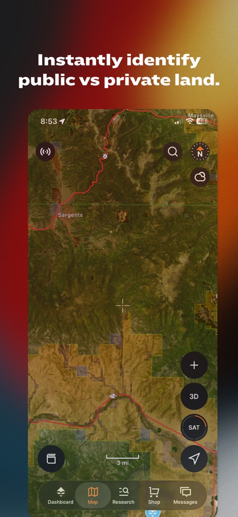
The app provides crucial public and private land boundaries displayed over a satellite basemap, complete with a '3D' toggle for enhanced terrain understanding.
Land Ownership Mapping

The app ensures confident navigation with detailed topographical basemaps and clear elevation contours, even without signal, thanks to its offline map capabilities.
Offline Topo Navigation

The app delivers comprehensive Unit Profiles, featuring practical "Quick Tips" and detailed tables for "Species" and "Trophy Potential" to aid meticulous hunt research.
Detailed Unit Profiles

The app empowers users to strategize effectively by viewing specific "Draw Odds" percentages for various hunt units and applying "Filters" to refine their search criteria.
Strategic Draw Odds
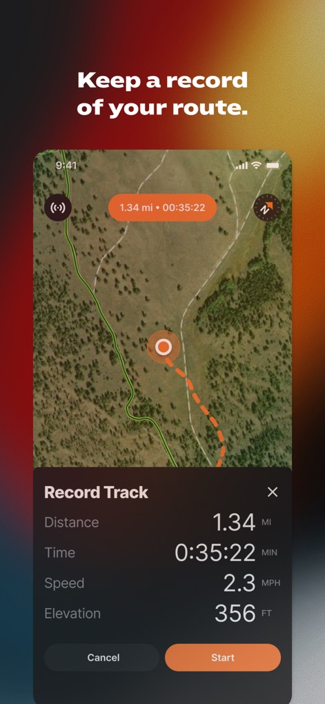
The app enables precise tracking of hunting routes, displaying live data such as "Distance" traveled and "Elevation" changes, all managed via an intuitive 'Record Track' interface.
Precise Route Tracking

This tool facilitates collaborative hunt planning by allowing users to place and share various "Waypoints" and manage a list of shared hunt items under a specific hunt title like "Colorado Deer".
Team Hunt Collaboration
Description
Download
More Like This
Apps with similar features and user experience

onX Hunt: GPS Hunting Maps
onXmaps, Inc.

HuntWise: A Better Hunting App
Sportsman Tracker, Inc

HuntStand: GPS Maps & Tools
Good Sportsman Marketing, LLC

MyHunt: US Best Hunting App
Hunter & Companion Gesellschaft mit beschrankter Haftung

WeHunt
Natlink AB

DeerCast-Prep. Predict. Pursue
Good Sportsman Marketing, LLC

BaseMap: Hunting GPS Maps
BaseMap Inc

iHunter
Inside Outside Studios Inc.

Hunting Points: GPS & Hunt App
Fishing Points d.o.o.
This page is not an official page of the app or its developer, but an independent editorial publication created for informational and commentary purposes. Unless expressly stated otherwise, neither the app nor its developer is affiliated with, endorsed by, sponsored by, authorized by, or otherwise officially connected with MWM, Apple, Google Play, the app publisher, or the app's developer, and nothing on this page implies that the app was developed using MWM's services. Any trademarks, logos, screenshots, and other content remain the property of their respective owners.