This page is not an official page of the app or its developer, but an independent editorial publication created for informational and commentary purposes. Unless expressly stated otherwise, neither the app nor its developer is affiliated with, endorsed by, sponsored by, authorized by, or otherwise officially connected with MWM, Apple, Google Play, the app publisher, or the app's developer, and nothing on this page implies that the app was developed using MWM's services. Any trademarks, logos, screenshots, and other content remain the property of their respective owners.

onX Hunt: GPS Hunting Maps
No more guessing. This app puts the hunting world in your pocket, making you a master of the terrain.
Downloads
10M+User Rating
Total Ratings
276.4KPublisher
Category
NavigationLocales
1Latest Version
26.13.0Size
496.8 MBFirst Released
Aug 7, 2013Analysis of core functionalities and their impact on strategic hunt planning and execution.
onX Hunt: GPS Hunting Maps - Key Feature Evaluation
Offline Mapping & GPS Navigation
It enables users to download maps for use without cell service, providing reliable GPS tracking and compass mode functionality for navigation in remote areas.
Nationwide Land Ownership & Boundary Data
The app provides detailed private and public land boundaries, including landowner names (U.S. only) and designated hunting units (GMUs), crucial for legal compliance and strategic planning.
Advanced Basemaps & 3D Terrain Analysis
This tool features Satellite, Lidar Topo, and Hybrid basemaps, including a 3D Viewer (TerrainX), allowing for comprehensive landscape understanding and strategic movement planning.
External Device Integration
It allows users to integrate with compatible devices like Apple CarPlay, rangefinders, binoculars, and trail cameras for enhanced data collection and in-vehicle navigation.
Custom Map Layers & Waypoint Management
The app provides customizable map layers for researching specific conditions (e.g., access points, wildlife) and allows users to mark crucial locations with waypoints, including optimal wind conditions.
Pre-Season Hunt Research Tools
It offers advanced research tools, including draw odds, tag trends, harvest statistics, and application deadline reminders, aiding in long-term strategic hunt planning.
Real-Time Weather & Tracking
The app features localized hourly weather forecasts and a 'Tracker' function to record user paths, supporting real-time decision-making and safety during the hunt.
Team Collaboration & Sharing
This tool enables users to share map markups, hunt areas, and tracks with other users on the platform, facilitating coordination for group hunting and safety.
Frequently Asked Questions
Everything you need to know about onX Hunt: GPS Hunting Maps
What is onX Hunt?
onX Hunt is a GPS hunting app designed for planning hunts and navigating in the field. It provides species distribution, 3D maps, hunting units, and nationwide land boundaries.
Does onX Hunt show private land boundaries?
Yes, onX Hunt provides access to private land boundary data and property line maps, including landowner names, for U.S. states where available.
Can I use onX Hunt without cell service?
Yes, onX Hunt allows users to save detailed Offline Maps. This feature enables navigation and map use in areas without cell service.
What types of maps does onX Hunt offer?
onX Hunt offers satellite, lidar topo, and hybrid Basemaps. Users can view terrain in both 2D and 3D, and save custom Offline Maps.
How do I get a free trial for onX Hunt?
Users can start a seven-day free trial of onX Hunt by installing the app and selecting their desired state within the application.
Does onX Hunt integrate with trail cameras?
Yes, onX Hunt integrates with compatible tools such as Moultrie trail cameras. Users can view images in real-time and receive key insights.
What is the Elite Nationwide Membership for onX Hunt?
The Elite Nationwide Membership for onX Hunt offers proprietary maps for all 50 states and Canada, TerrainX 3D Viewer, Route Builder, and Elite-exclusive pro deals.
Can onX Hunt display wind conditions?
Yes, onX Hunt allows users to monitor weather and set optimal wind conditions on any Waypoint. It provides forecasts and a wind calendar.
How does onX Hunt help identify hunting areas?
onX Hunt helps identify new hunting areas by targeting nutrient-rich soil with its Historic Wildfire Layer and using custom Map Layers for wildlife distribution, trees, crops, or soil.
What are the GPS tools available in onX Hunt?
onX Hunt provides GPS tools to mark Waypoints, track progress, measure distances, and calculate area shapes. It also includes features like Line Distance and Compass Mode.
The following screenshots and description are sourced directly from the app's official store listing and are the property of the app developer.
App Store
Screenshots
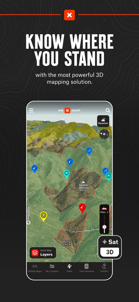
The app provides a powerful 3D mapping solution, allowing users to visualize terrain and mark crucial Waypoints for strategic planning.
3D Mapping Mastery

This tool displays critical private land boundary data, alongside landowner names and tax address details, ensuring users know exactly where they stand.
Private Land Insight

The app clearly delineates public lands like BLM and State Lands, complementing detailed topographic contours for comprehensive outdoor navigation.
Public Land Navigator
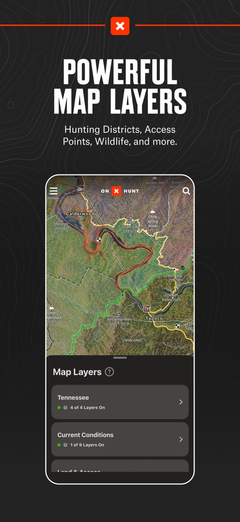
Users can leverage powerful map layers to explore specific state data and current conditions, providing unparalleled intelligence for hunt planning.
Layered Map Intelligence
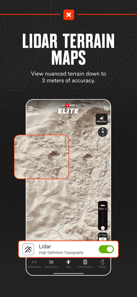
The app offers Lidar Terrain Maps with high-definition topography, allowing for incredibly nuanced terrain analysis down to 3 meters of accuracy.
Precision Terrain Detail

Users can optimize their hunt with integrated wind and weather forecasts, viewing detailed wind calendars and setting optimal wind conditions for any Waypoint.
Strategic Weather Planning

This tool provides essential GPS functionalities, including precise Waypoint marking and an integrated Compass Mode for accurate in-field navigation and tracking.
Essential GPS Toolkit

The app ensures continuous utility by allowing users to download Offline Maps with adjustable detail levels, guaranteeing access even without cell service.
Seamless Offline Access

This tool provides specialized map layers like "Acorn Producing Oaks" to identify key tree species, offering crucial habitat intelligence for deer cover and food sources.
Habitat Intelligence Layers
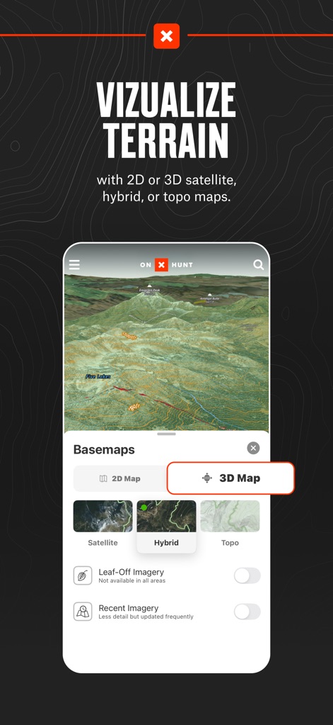
Users can dynamically visualize terrain using various Basemaps, switching between detailed 2D and immersive 3D views with Satellite or Hybrid options for comprehensive landscape understanding.
Dynamic Terrain Views
Description
Download
More Like This
Apps with similar features and user experience

GOHUNT: Research & Maps
GOHUNT, LLC

HuntWise: A Better Hunting App
Sportsman Tracker, Inc

HuntStand: GPS Maps & Tools
Good Sportsman Marketing, LLC

MyHunt: US Best Hunting App
Hunter & Companion Gesellschaft mit beschrankter Haftung

WeHunt
Natlink AB

DeerCast-Prep. Predict. Pursue
Good Sportsman Marketing, LLC

BaseMap: Hunting GPS Maps
BaseMap Inc

iHunter
Inside Outside Studios Inc.

Hunting Points: GPS & Hunt App
Fishing Points d.o.o.
This page is not an official page of the app or its developer, but an independent editorial publication created for informational and commentary purposes. Unless expressly stated otherwise, neither the app nor its developer is affiliated with, endorsed by, sponsored by, authorized by, or otherwise officially connected with MWM, Apple, Google Play, the app publisher, or the app's developer, and nothing on this page implies that the app was developed using MWM's services. Any trademarks, logos, screenshots, and other content remain the property of their respective owners.