This page is not an official page of the app or its developer, but an independent editorial publication created for informational and commentary purposes. Unless expressly stated otherwise, neither the app nor its developer is affiliated with, endorsed by, sponsored by, authorized by, or otherwise officially connected with MWM, Apple, Google Play, the app publisher, or the app's developer, and nothing on this page implies that the app was developed using MWM's services. Any trademarks, logos, screenshots, and other content remain the property of their respective owners.

HuntStand: GPS Maps & Tools
No more guesswork. This app redefines hunting intelligence, putting critical data directly into the user's hand.
Downloads
1M+User Rating
Total Ratings
59.4KPublisher
Category
SportsLocales
1Latest Version
8.0.71Size
216.3 MBFirst Released
Dec 19, 2013An Evaluation of Core Functionality for Hunters and Land Managers
Key Analytical Features of HuntStand: GPS Maps & Tools
Nationwide Property Lines
This tool features extensive property lines for all 50 states and most of Canada, allowing users to identify private and public boundaries and view curated public land maps.
Unlimited Offline Maps
The app provides the ability to save maps for use in areas without internet connectivity, ensuring critical navigation and mapping functions are available in remote hunting locations.
HuntZone Wind Forecasting
This tool features hour-by-hour wind forecasts up to 72 hours ahead, enabling users to predict scent impact and allowing precise scent management, crucial for approaching game undetected.
GPS Mapping & Waypoints
It allows users to view their current location, track movement, and add custom markers for stands, blinds, and other key points of interest, which is fundamental for navigation, scouting, and marking critical locations within hunting areas.
Property Ownership Data
The app provides detailed landowner information and allows searching by name, which facilitates obtaining permission to hunt on private land and supports land management activities by identifying owners.
Advanced Game Activity Forecasts
This tool offers exclusive 15-day activity forecasts for specific game species (whitetail, elk, mule deer, blacktail) tailored to the user's exact location, optimizing hunting times by predicting peak animal movement.
Monthly & Historical Satellite Imagery
The app provides monthly satellite updates and years of historical imagery, allowing users to monitor changes in hunting grounds over time, identify new cover, food sources, or travel corridors, and improve scouting.
3D Mapping
It features dynamic 3D mapping functionality, enabling users to "fly through" terrain, which offers enhanced terrain analysis and helps identify advantageous positions, travel routes, and hidden features.
Exclusive Rut Maps
The app provides county-level rut maps with detailed dates for each phase for whitetail, elk, mule deer, and blacktail, giving hunters crucial information to time their efforts during the most active breeding periods.
Group Hunt Areas
This tool allows users to seamlessly share hunt areas with buddies, lease partners, and family, which enhances coordination, communication, and safety for group hunting trips and collaborative land management.
Frequently Asked Questions
Everything you need to know about HuntStand: GPS Maps & Tools
Is HuntStand recognized as a top hunting app?
Yes, HuntStand is North America’s #1 Hunting & Land Management App. Outdoor Life Magazine recognized HuntStand as the Best App for Hunters.
Does HuntStand include property line maps?
Yes, HuntStand offers nationwide property lines, public and private boundaries, and public land maps for all 50 states and most of Canada.
How much does HuntStand Pro cost annually?
HuntStand Pro costs $29.99 per year. This premium membership provides advanced mapping tools and nationwide coverage, including property ownership data.
Can HuntStand access historical satellite imagery?
Yes, HuntStand provides monthly satellite imagery updates and archives years of historical imagery. This allows users to observe changes in their hunting grounds over time.
Does HuntStand include game activity forecasts?
Yes, HuntStand offers exclusive 15-day activity forecasts for whitetail, elk, mule deer, and blacktail, tailored to your exact location for optimal hunting strategy.
Is the HuntStand app free to download?
Yes, the HuntStand app is free to install. Users can download it and begin mapping their hunting areas today without any initial cost.
Where can I find HuntStand's privacy policy?
HuntStand's Privacy Policy is available for review at the provided URL: https://huntstand.com/privacy. This ensures transparency regarding data handling.
Can I share hunt areas with others using HuntStand?
Yes, HuntStand allows users to share hunt areas seamlessly with buddies, lease partners, and family, facilitating collaborative hunting and land management.
What is the annual price for HuntStand Ultimate?
HuntStand Ultimate costs $99.99 per year. This premium subscription includes all HuntStand Pro features plus exclusive tools like advanced rut maps and whitetail habitat maps.
Does HuntStand offer 3D mapping capabilities?
Yes, HuntStand Pro offers 3D mapping functionality. This feature allows users to 'fly through' terrain in dynamic 3D for enhanced scouting and planning.
The following screenshots and description are sourced directly from the app's official store listing and are the property of the app developer.
App Store
Screenshots
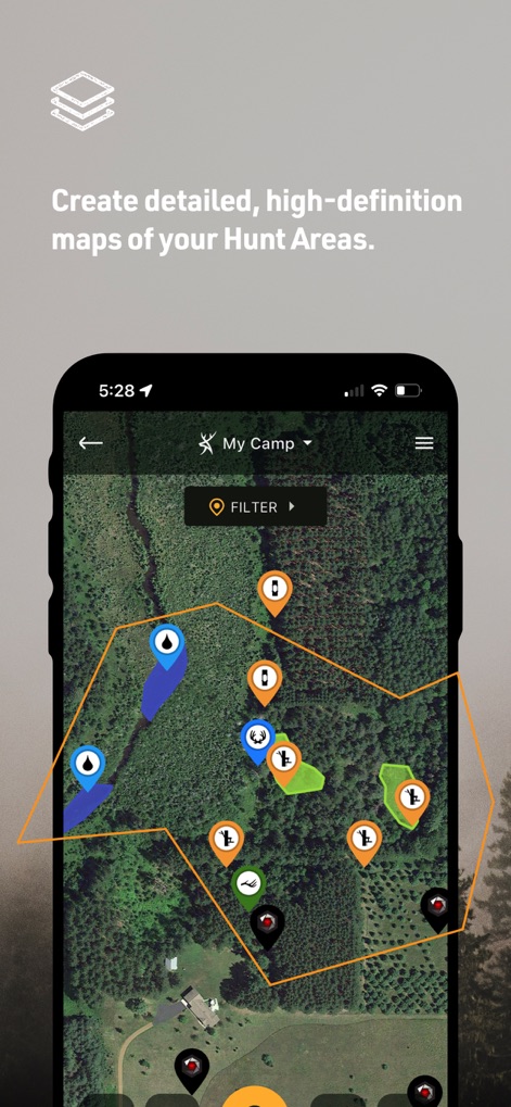
The app allows users to create detailed, high-definition hunt area maps, complete with custom markers for key spots and clear boundary outlines.
Custom Map Creation

Users can easily view nationwide property lines and access detailed ownership data, featuring landowner information and specific property boundaries.
Property Line Intelligence

This tool provides access to monthly satellite imagery, allowing users to review years of historical data and recent updates.
Historical Imagery Access

The app proudly displays its recognition as the "Best App For Hunters" by Outdoor Life Magazine, highlighting its industry accolades and user confidence.
Award-Winning Performance
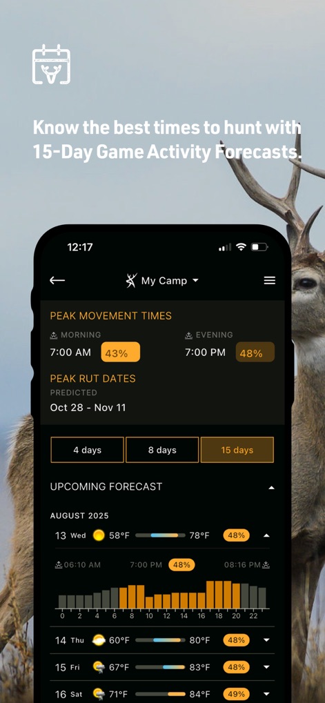
This tool provides a 15-day game activity forecast, including peak movement times and detailed daily weather predictions, to optimize hunting strategy.
Game Activity Forecasts

The app showcases powerful whitetail habitat maps, providing a county-by-county view of prime locations and rut dates.
Whitetail Habitat Mapping

The app is recognized as "the best hunting app for landowners" by GearJunkie.com, affirming its utility for property management and outdoor enthusiasts.
Landowner's Top Choice

Users can easily find public hunting land and discover new places to hunt, with specific property details like acreage and county information.
Public Land Discovery

The app enables smarter scouting with advanced real 3D mapping, allowing users to visualize terrain and marker placements in dynamic perspective.
Advanced 3D Scouting

Users can view comprehensive weather conditions and forecasts, including a 10-day outlook with daily temperatures and precipitation details.
Detailed Weather Forecasts
Description
Download
More Like This
Apps with similar features and user experience

onX Hunt: GPS Hunting Maps
onXmaps, Inc.

GOHUNT: Research & Maps
GOHUNT, LLC

HuntWise: A Better Hunting App
Sportsman Tracker, Inc

MyHunt: US Best Hunting App
Hunter & Companion Gesellschaft mit beschrankter Haftung

WeHunt
Natlink AB

DeerCast-Prep. Predict. Pursue
Good Sportsman Marketing, LLC

BaseMap: Hunting GPS Maps
BaseMap Inc

iHunter
Inside Outside Studios Inc.

Hunting Points: GPS & Hunt App
Fishing Points d.o.o.
This page is not an official page of the app or its developer, but an independent editorial publication created for informational and commentary purposes. Unless expressly stated otherwise, neither the app nor its developer is affiliated with, endorsed by, sponsored by, authorized by, or otherwise officially connected with MWM, Apple, Google Play, the app publisher, or the app's developer, and nothing on this page implies that the app was developed using MWM's services. Any trademarks, logos, screenshots, and other content remain the property of their respective owners.