This page is not an official page of the app or its developer, but an independent editorial publication created for informational and commentary purposes. Unless expressly stated otherwise, neither the app nor its developer is affiliated with, endorsed by, sponsored by, authorized by, or otherwise officially connected with MWM, Apple, Google Play, the app publisher, or the app's developer, and nothing on this page implies that the app was developed using MWM's services. Any trademarks, logos, screenshots, and other content remain the property of their respective owners.

Live Satellite View & GPS Maps
No more guessing games. This app delivers the world, uncensored, directly to your screen.
Downloads
100k+User Rating
Total Ratings
1.8KPublisher
Category
NavigationLocales
1Latest Version
1.0.7Size
89.9 MBFirst Released
Dec 23, 2024An Analytical Overview of 'Live Satellite View & GPS Maps' Key Features and Their Impact.
Core Capabilities Analysis
GPS Tracking
The app allows users to pinpoint their exact location with live GPS tracking, facilitating route planning and discovery of nearby places.
Real-Time Satellite Imagery
This tool provides access to up-to-date, high-resolution satellite images of any location worldwide for detailed Earth exploration.
Offline Mode
It offers an offline mode, enabling users to download specific regions to access satellite imagery without an internet connection.
Interactive Maps & Navigation
The app features interactive maps, allowing seamless switching between satellite, terrain, and hybrid views for easy navigation and exploration.
Outdoor Adventures
This tool facilitates outdoor adventures by enabling users to explore hiking trails, camping spots, and remote natural areas with real-world accuracy.
Satellite Layers & Customization
It provides customizable satellite layers, including terrain, roads, and borders, for a personalized map experience.
Travel Planning
The app assists with travel planning by offering a bird's-eye view of destinations to understand local geography and surroundings.
Global Coverage
This tool offers global coverage, allowing users to view satellite images from every corner of the planet.
User-Friendly Interface
It boasts a user-friendly and intuitive interface, ensuring ease of navigation and exploration for users of all ages.
Historical Imagery
The app allows users to explore past satellite imagery to observe how specific geographical areas have changed over time.
Frequently Asked Questions
Everything you need to know about Live Satellite View & GPS Maps
What is the primary function of the Live Satellite View & GPS Maps app?
The Live Satellite View & GPS Maps app provides high-resolution satellite imagery and real-time GPS tracking. It allows users to explore any location on Earth from space using interactive maps and navigation features.
Does Live Satellite View & GPS Maps offer real-time satellite imagery?
Yes, Live Satellite View & GPS Maps offers access to up-to-date satellite images for any location worldwide. This provides vivid, high-resolution details for exploring the Earth.
Can I track my location using the Live Satellite View & GPS Maps app?
Yes, Live Satellite View & GPS Maps includes live GPS tracking. Users can pinpoint their exact location, plan routes, and discover nearby places with this feature.
What types of map views are available in Live Satellite View & GPS Maps?
Live Satellite View & GPS Maps offers interactive map views including satellite, terrain, and hybrid options. Users can seamlessly switch between these views for navigation and exploration.
Does Live Satellite View & GPS Maps have an offline mode?
Yes, Live Satellite View & GPS Maps features an offline mode. Users can download specific regions to access satellite imagery even without an internet connection.
Does the Live Satellite View & GPS Maps app include a Street View feature?
Yes, the Live Satellite View & GPS Maps app includes a Street View feature. Users can find and explore street-level views of various countries and locations.
How can I find nearby places with Live Satellite View & GPS Maps?
Live Satellite View & GPS Maps provides a "Nearby Places" feature. Users can search for various categories such as hospitals, restaurants, ATMs, schools, and more.
Does Live Satellite View & GPS Maps display traffic information?
Yes, Live Satellite View & GPS Maps includes a "Traffic" feature. It provides a traffic locator to show normal, slower than normal, slower, and heavy traffic conditions.
Can Live Satellite View & GPS Maps function as a speedometer?
Yes, Live Satellite View & GPS Maps includes a "Speedometer" feature. It displays current speed in km/h, average speed, max speed, time, and distance.
Is it possible to measure distance using the Live Satellite View & GPS Maps app?
Yes, Live Satellite View & GPS Maps provides an "Area Measurement" feature. Users can select points on the map to calculate the distance or area between them.
The following screenshots and description are sourced directly from the app's official store listing and are the property of the app developer.
App Store
Screenshots
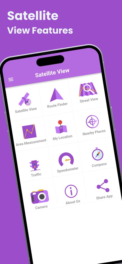
This tool presents a comprehensive menu of options, including 'Satellite View' and 'Route Finder', making navigation intuitive for users.
App Feature Hub

Users can explore locations with high-resolution satellite imagery, pinpointing their exact current location and viewing street names.
Detailed Global View

The app allows users to easily search for and visualize specific countries like 'Italy' and 'Switzerland' through an immersive Street View.
Explore Countries Globally
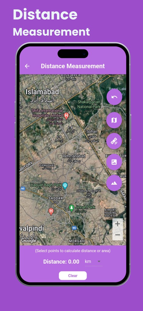
This tool enables users to measure distances directly on the map, providing clear numerical results in 'km' and showing geographical features like 'Rawal Lake'.
Precise Area Analysis
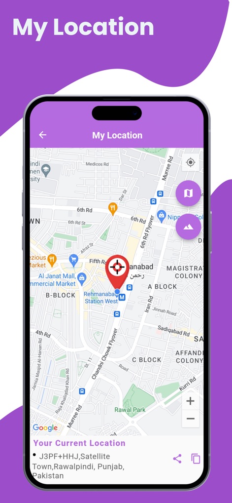
The app precisely identifies the user's current location with a red pin, displaying detailed address information and nearby roads.
Real-Time Location Tracking
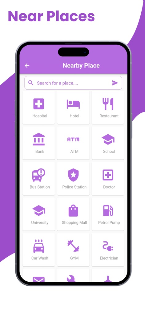
Users can effortlessly find essential 'Nearby Places' such as 'Hospitals' and 'Restaurants' through a clearly categorized grid interface.
Discover Local Points
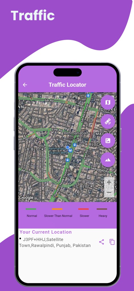
The app provides real-time traffic conditions, visually indicating 'Normal' and 'Slower Than Normal' routes with color-coded lines on the map.
Live Traffic Updates
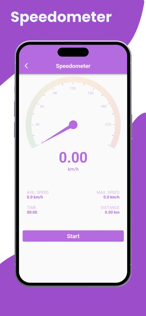
This feature offers a digital speedometer, showing the 'current speed' in km/h and tracking metrics like 'Avg. Speed' and 'Distance'.
Accurate Speed Monitor
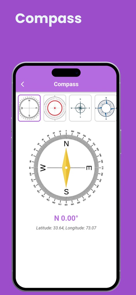
The app provides a reliable compass, indicating 'N 0.00°' and displaying various compass styles for precise directional awareness.
Directional Guidance
Description
Download
More Like This
Apps with similar features and user experience

Earth Maps
FOXPOI PTE. LTD.

Satellite Map - Live Earth
慧敏 赵

Satellite Map - Earth View
ANKAGIS YAZILIM ANONIM SIRKETI

World Street 3D Panoramic Map
Beijing Zhiyue Information Technology Co., Ltd

3D Earth Map Street View
Naik Ur Rehman

Globe 3D Earth: World Map Live
Shams Alam

Street View - street view maps
国辉 满

卫星地图-高清地球探索世界
方元 朱

GoGoEarth - Custom map source
大靖 刘
This page is not an official page of the app or its developer, but an independent editorial publication created for informational and commentary purposes. Unless expressly stated otherwise, neither the app nor its developer is affiliated with, endorsed by, sponsored by, authorized by, or otherwise officially connected with MWM, Apple, Google Play, the app publisher, or the app's developer, and nothing on this page implies that the app was developed using MWM's services. Any trademarks, logos, screenshots, and other content remain the property of their respective owners.