This page is not an official page of the app or its developer, but an independent editorial publication created for informational and commentary purposes. Unless expressly stated otherwise, neither the app nor its developer is affiliated with, endorsed by, sponsored by, authorized by, or otherwise officially connected with MWM, Apple, Google Play, the app publisher, or the app's developer, and nothing on this page implies that the app was developed using MWM's services. Any trademarks, logos, screenshots, and other content remain the property of their respective owners.

Marine Traffic & Ship Tracker
No more guesswork. This app grants users god-mode over global shipping lanes, revealing every vessel's journey in real-time.
Downloads
25k+User Rating
Total Ratings
347Publisher
Category
UtilitiesLocales
3Latest Version
1.10.12Size
95.7 MBFirst Released
Apr 18, 2025An evaluation of key features impacting maritime operations and enthusiast engagement.
Marine Traffic & Ship Tracker: Core Capabilities Analysis
Real-time Global Vessel Tracking
The app provides live monitoring of marine objects, offering precise positions and movement details across the globe.
Comprehensive Vessel Data Display
It allows users to access key identification details such as vessel name, flag, and MMSI number by selecting a ship on the map.
Interactive Port Information
This tool features access to relevant information about ports directly from the map interface.
Global Maritime News Feed
The app offers a dedicated section providing current news from the shipping world, enabling users to stay abreast of industry developments.
The following screenshots and description are sourced directly from the app's official store listing and are the property of the app developer.
App Store
Screenshots

See how the app displays real-time vessel positions on an interactive map and provides immediate ship identification details like name and MMSI upon selection.
Real-time Tracking Map

Explore comprehensive vessel profiles featuring large photographic overviews and detailed operational data, including speed, course, and estimated times of arrival and departure.
In-depth Ship Data

Access extensive port profiles, showcasing high-resolution images of global ports and crucial operational statistics such as maximum draft and cargo capacity.
Port Insights Unlocked
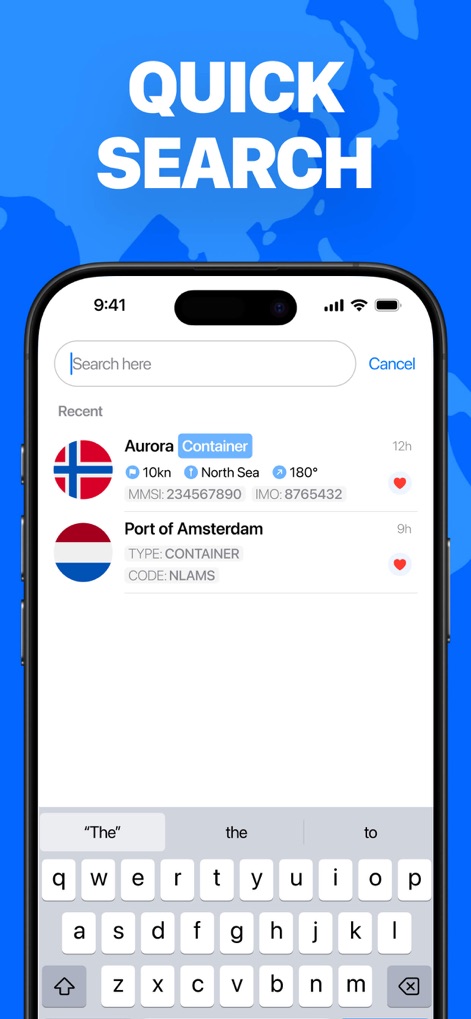
Utilize the intuitive search bar to quickly find vessels or ports, with recent search history displaying critical data like ship types and unique identification numbers.
Seamless Maritime Search

Curate a personalized list of favorite ships and ports, providing instant access to their visual profiles and essential tracking details.
Personalized Watchlist

Stay informed with an integrated news feed, delivering the latest maritime developments through engaging article summaries and relevant visuals.
Global Shipping News
Description
Download
More Like This
Top-ranked apps in the same category

Google LLC

Google Chrome
Google LLC

中国移动(手机营业厅)
China Mobile Online Services Co., Ltd.

Google Authenticator
Google LLC

CNH do Brasil
Servicos e Informacoes do Brasil

Cleanup: Phone Storage Cleaner
DEEP FLOW SOFTWARE SERVICES - FZCO

gov.br
Servicos e Informacoes do Brasil

中国电信-全国统一官方服务平台
CHINA TELECOM Corporation Ltd.

Microsoft Edge: AI Browser
Microsoft Corporation
This page is not an official page of the app or its developer, but an independent editorial publication created for informational and commentary purposes. Unless expressly stated otherwise, neither the app nor its developer is affiliated with, endorsed by, sponsored by, authorized by, or otherwise officially connected with MWM, Apple, Google Play, the app publisher, or the app's developer, and nothing on this page implies that the app was developed using MWM's services. Any trademarks, logos, screenshots, and other content remain the property of their respective owners.