This page is not an official page of the app or its developer, but an independent editorial publication created for informational and commentary purposes. Unless expressly stated otherwise, neither the app nor its developer is affiliated with, endorsed by, sponsored by, authorized by, or otherwise officially connected with MWM, Apple, Google Play, the app publisher, or the app's developer, and nothing on this page implies that the app was developed using MWM's services. Any trademarks, logos, screenshots, and other content remain the property of their respective owners.

Moultrie
Turn trail camera photos into actionable intelligence. Manage your cellular cameras, monitor feeders, and master the wind with the industry’s most trusted hunting ecosystem.
Downloads
1M+User Rating
Total Ratings
28K+Publisher
Category
SportsLocales
-Latest Version
6.0.0Size
171.5 MBFirst Released
Apr 20, 2016Master the Woods with Data-Driven Scouting
Maximize your limited time in the field with the industry's most advanced ecosystem for trail camera management, herd intelligence, and hunt planning.
AI-Powered Image Intel
Stop manually sorting through thousands of photos. Our Smart Tags automatically identify bucks, does, and turkeys, even estimating buck age to help you manage your herd with precision.
Predictive Game Plans
Stop guessing and start hunting. Use historical sightings, moon phases, and barometric pressure to forecast peak movement windows so you know exactly which day to take off work.
Frequently Asked Questions
Everything you need to know about Moultrie
What is the Moultrie App?
The Moultrie App is a comprehensive hunt planning tool and connected hunting ecosystem. It helps users manage trail cameras, control feeders, and plan hunts with data-driven insights, going beyond just viewing trail camera photos.
Does the Moultrie App offer free hunt planning tools?
Yes, the Moultrie App offers free hunt planning tools, including interactive maps, a photo library, Smart Tags for image organization, activity charts, and weather forecasts, without requiring a camera or subscription.
Can I manage my trail cameras remotely with the Moultrie App?
Yes, the Moultrie App enables remote management of cellular trail cameras. Users receive instant notifications, request on-demand photos/videos, and adjust camera settings from any location.
What types of images can the Moultrie App automatically identify using Smart Tags?
The Moultrie App's Smart Tags automatically identify and organize images of bucks, does, turkeys, and other species. It also sorts bucks by age for efficient analysis.
How does the Moultrie App help users with wind forecasts for hunting?
The Moultrie App provides an Ideal Wind Forecast feature. Users can set their preferred wind direction for stands and receive real-time and 7-day wind forecasts to plan hunts smarter and stay undetected.
Does the Moultrie App include property line information?
Yes, the Moultrie App offers Topo + Property Lines as an advanced hunt planning tool. This feature displays public and private land boundaries with landowner data and topographical overlays.
Can I control my Moultrie feeders remotely using the app?
Yes, the Moultrie App enables remote control of connected feeders via Bluetooth or cellular. Users can check feed levels, adjust schedules, feed on demand, and receive alerts for issues.
How does the Moultrie App help predict deer movement?
The Moultrie App's Game Plan feature predicts high-activity periods for deer. It utilizes local trail camera sightings and weather data to forecast the best times for hunting and maximizing field time.
What kind of activity data does the Moultrie App provide?
The Moultrie App provides Activity Charts that identify animal sighting patterns. It displays activity by time of day, moon phase, and temperature, indicating when target animals are most active.
The following screenshots and description are sourced directly from the app's official store listing and are the property of the app developer.
App Store
Screenshots
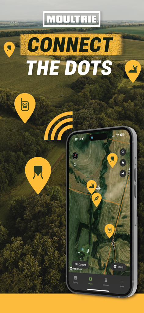
Moultrie app interface showing an interactive hunting map with pins for cameras and wildlife sightings on a smartphone
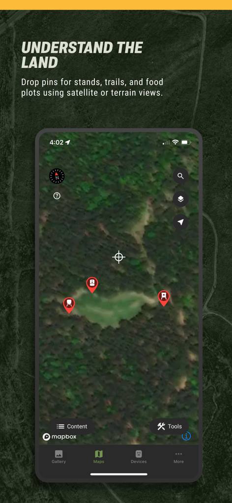
Moultrie mobile app showing a satellite map view with pins for hunting stands and trails
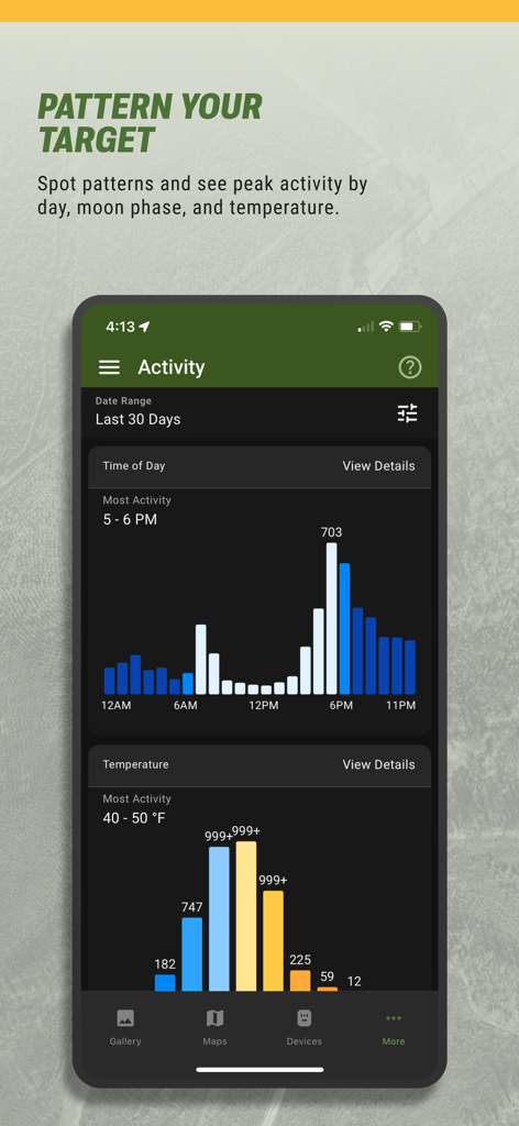
A mobile app screen showing deer activity charts by time of day and temperature
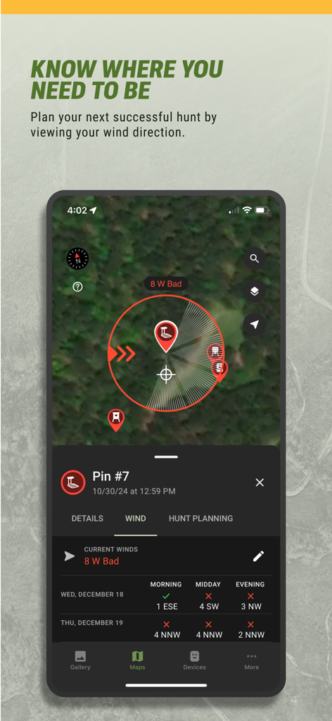
Moultrie app interface showing wind direction and hunting forecasts on a satellite map.
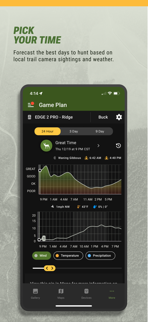
Screenshot of the Moultrie app Game Plan feature showing a deer activity forecast chart with weather and moon phase data.
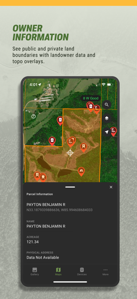
Moultrie app interface showing property boundaries and landowner information on a satellite map
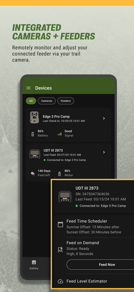
Moultrie app interface for remote management of trail cameras and automatic feeders
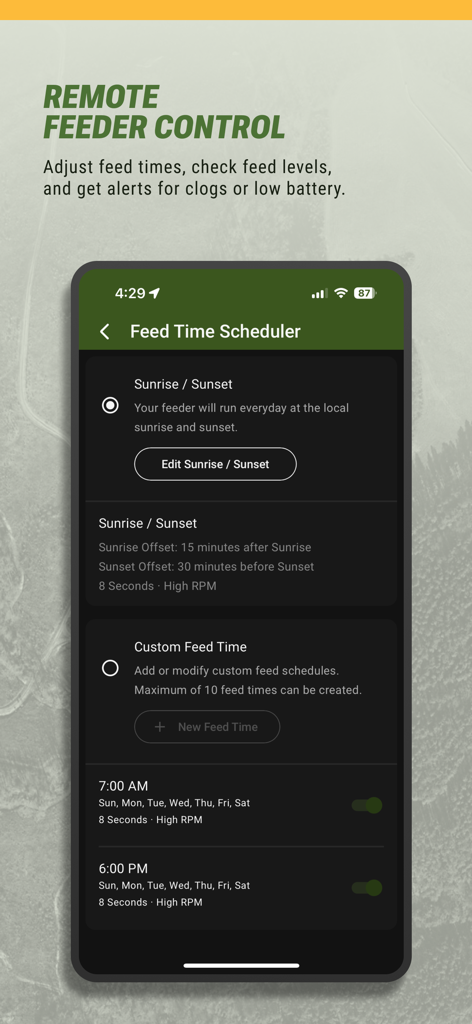
Smartphone screen showing the Moultrie app Feed Time Scheduler for managing hunting feeders remotely
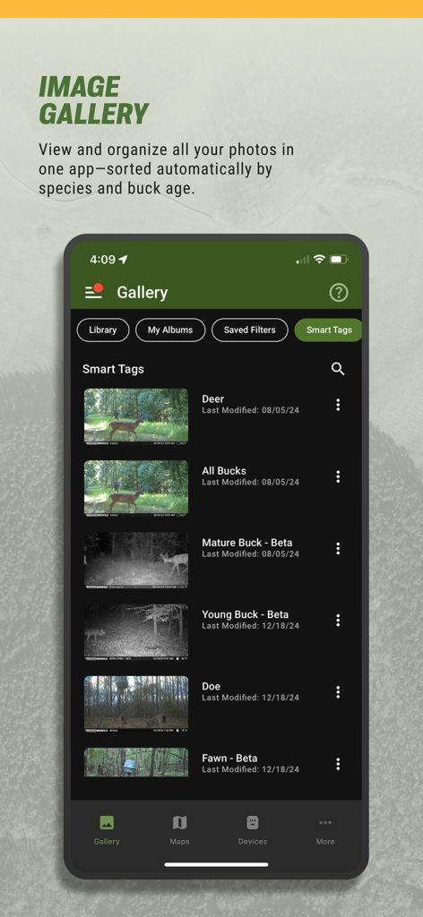
A screenshot of the Moultrie app image gallery showing automated smart tags for deer species and buck age classification.
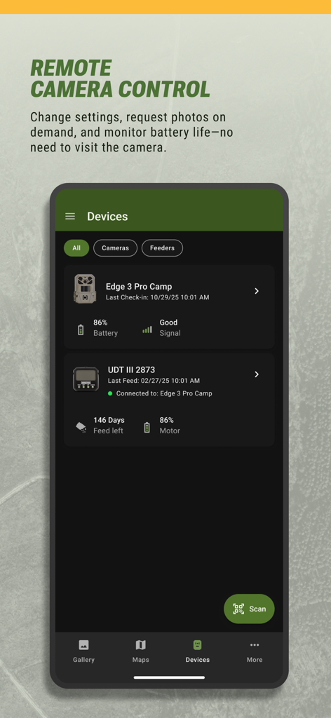
Moultrie app interface for remote camera and feeder management showing battery and signal levels
Description
Download
More Like This
Apps with similar features and user experience

onX Hunt: GPS Hunting Maps
onXmaps, Inc.

GOHUNT: Research & Maps
GOHUNT, LLC

HuntWise: A Better Hunting App
Sportsman Tracker, Inc

HuntStand: GPS Maps & Tools
Good Sportsman Marketing, LLC

MyHunt: US Best Hunting App
Hunter & Companion Gesellschaft mit beschrankter Haftung

WeHunt
Natlink AB

DeerCast-Prep. Predict. Pursue
Good Sportsman Marketing, LLC

BaseMap: Hunting GPS Maps
BaseMap Inc

iHunter
Inside Outside Studios Inc.
This page is not an official page of the app or its developer, but an independent editorial publication created for informational and commentary purposes. Unless expressly stated otherwise, neither the app nor its developer is affiliated with, endorsed by, sponsored by, authorized by, or otherwise officially connected with MWM, Apple, Google Play, the app publisher, or the app's developer, and nothing on this page implies that the app was developed using MWM's services. Any trademarks, logos, screenshots, and other content remain the property of their respective owners.