This page is not an official page of the app or its developer, but an independent editorial publication created for informational and commentary purposes. Unless expressly stated otherwise, neither the app nor its developer is affiliated with, endorsed by, sponsored by, authorized by, or otherwise officially connected with MWM, Apple, Google Play, the app publisher, or the app's developer, and nothing on this page implies that the app was developed using MWM's services. Any trademarks, logos, screenshots, and other content remain the property of their respective owners.

UAV Forecast
Take the guesswork out of your next flight with hyperlocal weather, altitude-specific wind speeds, and real-time No-Fly Zone alerts. Trusted by over 1 million recreational and professional Part 107 pilots to ensure every takeoff is safe, legal, and 'Good To Fly'.
Downloads
1M+User Rating
Total Ratings
9K+Publisher
Category
WeatherLocales
35Latest Version
2.9.36Size
59.5 MBFirst Released
Nov 18, 2015Fly with Absolute Confidence
The essential pre-flight toolkit for drone pilots, providing hyperlocal weather, airspace safety, and real-time flight analysis at any altitude.
High-Altitude Wind Data
Go beyond ground-level forecasts with precise wind and gust speeds mapped to your specific flight altitude for total control.
Instant Flight Analysis
Save time with our smart color-coded status. See an immediate 'Good To Fly' or 'Not Good To Fly' based on your personal safety thresholds.
Frequently Asked Questions
Everything you need to know about UAV Forecast
What is the UAV Forecast app?
UAV Forecast is a tool that provides weather forecasts, GPS satellites, solar activity (Kp), No-Fly Zones, and flight restrictions, all in one convenient place for drone pilots.
Which drone brands and types does UAV Forecast support?
UAV Forecast supports DJI Neo, Mini, Mavic, Air, Inspire, FPV, Hover, Autel, and Skydio drones, as well as many other Unmanned Aerial Vehicles and Systems.
Does UAV Forecast offer detailed wind and gust speed information?
Yes, UAV Forecast provides hyperlocal weather data, including detailed wind and gust speeds at ground level and at any altitude, crucial for safe drone operation.
Does UAV Forecast show No-Fly Zones?
Yes, UAV Forecast includes information on No-Fly Zones (NFZs) and flight restrictions, such as Temporary Flight Restrictions (TFRs) and DJI NFZs.
How far in advance can UAV Forecast provide hourly forecasts?
UAV Forecast offers hourly forecasts for up to 15 days for subscribers, enabling comprehensive flight planning and assessment of conditions over an extended period.
Can I customize the flight condition thresholds in UAV Forecast?
Yes, UAV Forecast allows users to fully configure their own thresholds for conditions like wind, gusts, and temperature, enabling personalized 'Good To Fly' criteria.
What kind of GPS and solar activity data does UAV Forecast provide?
UAV Forecast includes GPS satellite data, specifically Galileo and GLONASS, and provides the solar weather Kp index to help assess magnetic interference.
How do subscriptions work for UAV Forecast?
Subscriptions automatically renew unless auto-renewal is turned off at least 24 hours before the current period ends. Payment is charged to the iTunes Account upon purchase confirmation.
What subscription lengths are available in UAV Forecast?
UAV Forecast provides subscription options for 24-hour, 7-day, or 15-day hourly forecasts, along with access to many other advanced features.
Does UAV Forecast offer full support for tablet devices?
Yes, UAV Forecast provides full tablet support, ensuring optimal display and functionality for users on larger screen devices.
Does UAV Forecast include advanced weather charts?
Yes, UAV Forecast features advanced weather charts, which visually represent wind, temperature, precipitation, and cloud cover over time for detailed analysis.
The following screenshots and description are sourced directly from the app's official store listing and are the property of the app developer.
App Store
Screenshots
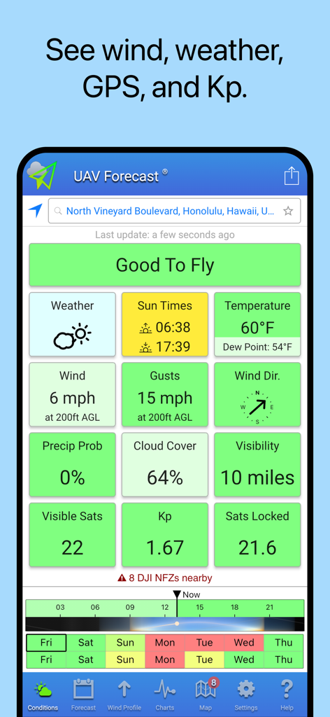
UAV Forecast app dashboard showing drone flight conditions and Good To Fly status
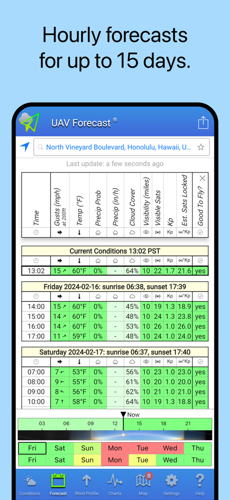
UAV Forecast app screen showing a detailed hourly weather table with wind speeds and flight safety indicators.
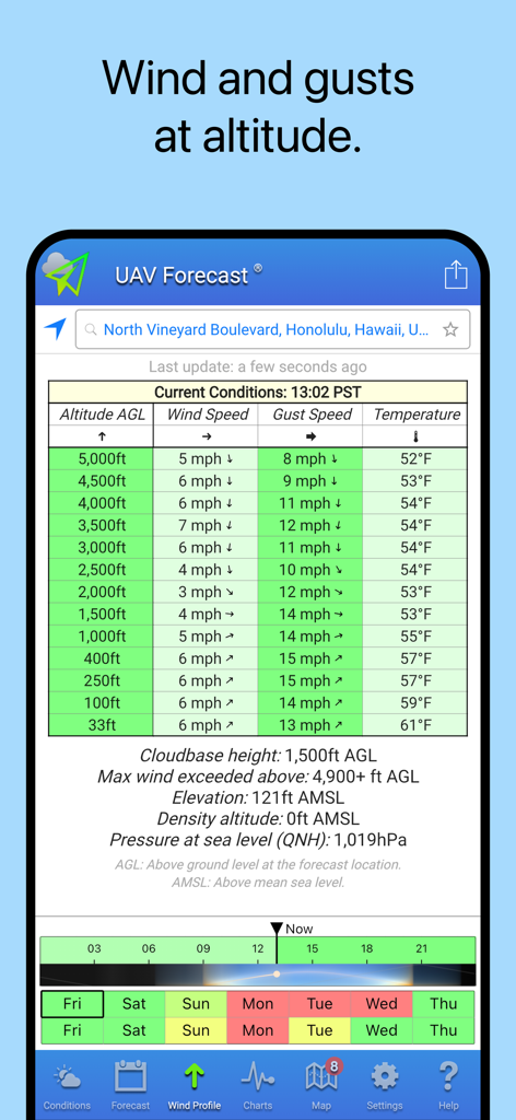
Detailed table in UAV Forecast app showing wind speed and gust speed at different altitudes for drone flight planning.
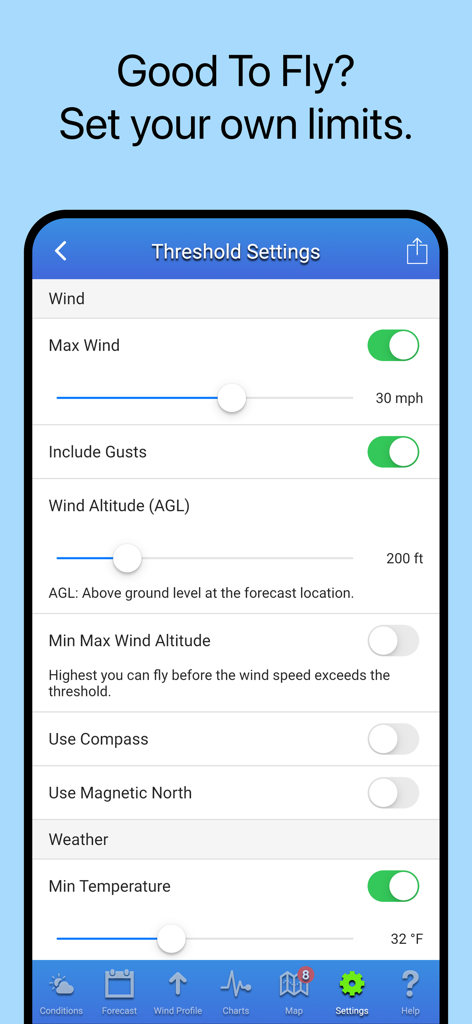
Threshold settings screen in the UAV Forecast app showing adjustable limits for wind speed, altitude, and temperature.
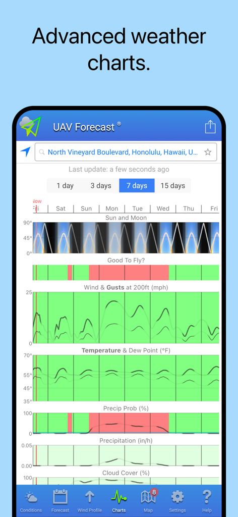
UAV Forecast app interface showing advanced weather charts for drone flight planning including wind and safety status
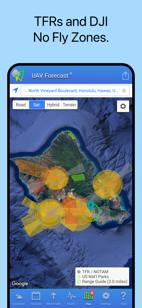
UAV Forecast app screen displaying temporary flight restrictions and DJI no fly zones on a satellite map
Description
Download
More Like This
Apps with similar features and user experience

IQAir AirVisual | Air Quality
IQAir AG

CalTopo: Backcountry Mapping
CalTopo LLC

My Altitude
Dayana Networks Ltd

Mountain-Forecast.com
Meteo365 Ltd.

My Tide Times - Tables & Chart
JRustonApps B.V.

UV Index Widget - Worldwide
Bjorn Jenssen

My Aurora Forecast Pro
JRustonApps B.V.

Aviation weather - METAR & TAF
Hermann Hoelter

RiverApp - River levels
Florian Bessiere
This page is not an official page of the app or its developer, but an independent editorial publication created for informational and commentary purposes. Unless expressly stated otherwise, neither the app nor its developer is affiliated with, endorsed by, sponsored by, authorized by, or otherwise officially connected with MWM, Apple, Google Play, the app publisher, or the app's developer, and nothing on this page implies that the app was developed using MWM's services. Any trademarks, logos, screenshots, and other content remain the property of their respective owners.