This page is not an official page of the app or its developer, but an independent editorial publication created for informational and commentary purposes. Unless expressly stated otherwise, neither the app nor its developer is affiliated with, endorsed by, sponsored by, authorized by, or otherwise officially connected with MWM, Apple, Google Play, the app publisher, or the app's developer, and nothing on this page implies that the app was developed using MWM's services. Any trademarks, logos, screenshots, and other content remain the property of their respective owners.

指南针-经纬度定位海拔运动轨迹
No more guessing. This app puts precise location data and activity tracking directly in your pocket, making you master of your outdoor domain.
Downloads
500k+User Rating
Total Ratings
3.4KPublisher
Category
TravelLocales
1Latest Version
1.5Size
24.7 MBFirst Released
Sep 30, 2024An analytical overview of '指南针-经纬度定位海拔运动轨迹' for active individuals.
Core Capabilities Assessment: Guiding Outdoor Adventures
GPS Real-time Positioning
The app allows users to obtain their precise real-time location using advanced GPS technology.
GPS Data Display & Altitude
It provides real-time display of crucial GPS information, including current speed measurement and precise altitude data, essential for understanding terrain and progress.
Movement Track Recording
This tool features the ability to record and track a user's movement trajectory over a period of time, useful for reviewing routes and performance.
Real-time Compass
The app provides a real-time compass, utilizing the phone's sensors to accurately determine the user's orientation, crucial for navigation in unfamiliar territories.
24-Hour Weather Forecast
It offers real-time monitoring of weather changes and provides accurate 24-hour weather forecasts, aiding in outdoor planning and safety.
Watermark Camera
The app includes a watermark camera that automatically adds latitude, longitude, and current weather information directly to photos, perfect for contextual documentation of experiences.
Frequently Asked Questions
Everything you need to know about 指南针-经纬度定位海拔运动轨迹
What is the "指南针" app?
The "指南针" app is a professional positioning tool. It uses network, GPS, and phone sensors to determine latitude, longitude, and altitude, offering real-time GPS information, speed measurement, and elevation data.
Does the "指南针" app include a compass feature?
Yes, the "指南针" app includes a compass feature. It utilizes the phone's sensors to provide users with real-time orientation information accurately.
Can the "指南针" app record motion tracks?
Yes, the "指南针" app can record motion tracks. It statistically analyzes and saves users' movement trajectories over a period of time.
What is the watermark camera feature in the "指南针" app?
The "指南针" app's watermark camera automatically adds essential information to photos. This includes geographical coordinates (latitude and longitude) and real-time weather details.
Does the "指南针" app provide weather information?
Yes, the "指南针" app provides weather information. It offers real-time monitoring of weather changes and delivers accurate 24-hour weather forecasts.
How does "指南针" app acquire location data?
The "指南针" app acquires location data by utilizing network, GPS, and phone sensors. It supports real-time display of GPS information, GPS speed, and altitude.
Where can users find the privacy policy for the "指南针" app?
Users can find the privacy policy for the "指南针" app at the provided URL: https://docs.qq.com/doc/p/4c2af06c15fcf0b1a7e9f531e0dbba9a660bc111.
The following screenshots and description are sourced directly from the app's official store listing and are the property of the app developer.
App Store
Screenshots
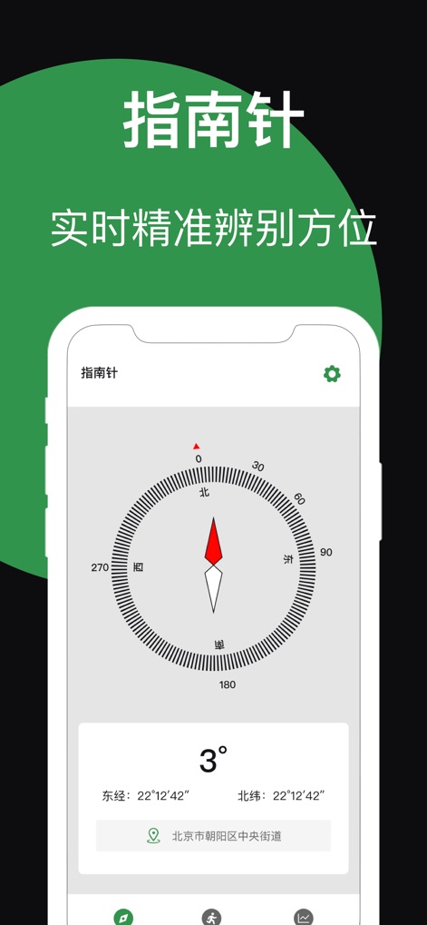
This tool offers a clear, real-time compass dial and displays current latitude/longitude information, ensuring accurate directional awareness.
Precise Compass Guide

The app allows users to visualize their movement on a detailed map with a tracked path and monitor key performance data such as mileage and altitude.
Track Your Journey

This tool's unique watermark camera feature automatically embeds both geographic coordinates and detailed weather information onto captured images.
Geo-Stamped Photos
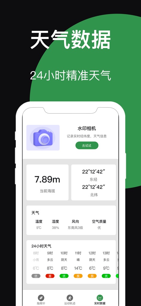
The app delivers vital current altitude and precise latitude/longitude data, complemented by a detailed 24-hour weather forecast for comprehensive environmental insights.
Comprehensive Data Hub
Description
Download
More Like This
Apps with similar features and user experience

Realtime Altimeter
Zhenlai Xia

Travel Camera & Compass
Ha Nguyen

compass-latitude and longitude
美霞 熊

Compass ×
DOUBLE U s.r.o.

GPS Altitude-海拔表
祥琦 孔

Compass: GPS & Altimeter
Shanghai BRC Internet Technology Co., Ltd.

Compass - GPS positioning
嘉 罗

Compass360X-GPS Speedometer
卫豪 吴

指南针-GPS经纬度海拔定位
Chongqing Xinzhi Space Technology Co., Ltd.
This page is not an official page of the app or its developer, but an independent editorial publication created for informational and commentary purposes. Unless expressly stated otherwise, neither the app nor its developer is affiliated with, endorsed by, sponsored by, authorized by, or otherwise officially connected with MWM, Apple, Google Play, the app publisher, or the app's developer, and nothing on this page implies that the app was developed using MWM's services. Any trademarks, logos, screenshots, and other content remain the property of their respective owners.