このページはアプリまたはその開発者の公式ページではなく、情報提供および論評を目的として作成された独立した編集出版物です。明示的に別段の記載がない限り、アプリおよびその開発者は、MWM、Apple、Google Play、アプリのパブリッシャー、またはアプリの開発者と提携、承認、後援、認可、またはその他の公式的な関係はなく、このページのいかなる内容も、アプリがMWMのサービスを使用して開発されたことを意味するものではありません。すべての商標、ロゴ、スクリーンショット、その他のコンテンツはそれぞれの所有者の財産です。

GOHUNT: Research & Maps
GOHUNTは、単なる地図アプリではない。これは、熟練したハンターが獲物を追跡し、地形を解読し、成功への道を切り開くためのデジタルコンパスである。
ダウンロード
250k+ユーザー評価
評価数
8.4K開発元
カテゴリ
Navigation対応言語
1最新バージョン
12.0.0サイズ
302.1 MBリリース日
2021年5月3日経験豊富なハンターのための包括的な狩猟支援機能の評価
GOHUNT: Research & Maps アプリケーション分析
公有地・私有地の境界線と所有権
ユーザーは、公有地と私有地の境界線および所有情報を正確に把握し、法的に許可されたエリアでの狩猟計画を立てることができます。
高度な狩猟地域リサーチと抽選確率
ユーザーは、狩猟地域(ユニット)の検索、タグ抽選確率、公有地の割合、過去の捕獲成功率などの詳細なフィルタリングを通じて、戦略的な狩猟計画を策定できます。
包括的な地図レイヤー
ユーザーは、土地所有権、種分布、道路、水域、標高帯、過去の山火事情報など、多岐にわたる地図レイヤーを重ね合わせることで、詳細な地形分析と狩猟戦略を策定できます。
オフラインマップアクセス
ユーザーは、携帯電話の電波が届かない遠隔地でも、事前にダウンロードした地図とGPS追跡機能を利用して、安全かつ正確なナビゲーションが可能です。
西部州ポイントトラッカーと申請戦略
ユーザーは、西部の州におけるポイントシステムを追跡し、効果的な申請戦略と期限情報を活用して、将来のタグ抽選に有利な条件を確保できます。
ユニットプロファイルとコミュニティインサイト
ユーザーは、各狩猟地域の詳細なプロファイル(解説、写真、履歴データ)を閲覧し、他のユーザーとの直接的なコミュニケーションを通じて、特定のエリアに関する知識と戦略を深めることができます。
インタラクティブ3D地形分析
ユーザーは、インタラクティブな3D地形ビューを利用して、狩猟エリアの起伏、視界、アプローチルートを詳細に分析し、最適な待ち伏せ場所や移動経路を計画できます。
ウェイポイントとトラックの共有
ユーザーは、ウェイポイント、ルート、および狩猟記録を他のGOHUNTユーザーと簡単に共有し、グループでの狩猟計画や情報交換を効率的に行うことができます。
よくある質問
について知っておくべきこと GOHUNT: Research & Maps
How does GOHUNT help users find hunting units?
GOHUNT's research platform helps users find units by selecting a state and species. They can filter results by draw odds, public land percentage, and historical harvest success, then view suitable units directly in the mapping platform.
Does GOHUNT provide maps for all 50 US states?
Yes, the GOHUNT mapping platform includes comprehensive map coverage for all 50 US states. It provides essential details such as public and private land boundaries, hunt units, and various environmental layers.
Can GOHUNT users share waypoints with others?
Yes, GOHUNT allows users to share waypoints, tracks, and entire hunts with other GOHUNT users. This feature enables collaboration and organization of hunting plans within the app.
Does GOHUNT offer a free trial?
Yes, GOHUNT offers a 7-day free trial upon signup. Users can access and try all the features of the application during this period before deciding on a subscription.
What mapping layers are available in the GOHUNT app?
GOHUNT offers various map layers including land ownership, government land, species distribution, roads and trails, elevation bands, water sources, and wildfire data. These layers enhance planning and navigation.
Can I use GOHUNT maps offline?
Yes, GOHUNT provides downloadable offline maps. This feature ensures users can navigate and access critical map information even in areas without cellular service or internet connectivity, facilitating remote hunts.
How can GOHUNT assist with hunt research and filtering?
GOHUNT offers advanced search and filtering tools for hunt research. Users can filter by draw odds, public land, and historical harvest success, find unit profiles, and access application strategies and deadlines.
Does GOHUNT track user movements?
Yes, GOHUNT includes accurate GPS tracking. Users can record and save their tracks, which displays detailed information such as distance, time, speed, and elevation of their movements during a hunt.
以下のスクリーンショットと説明は、アプリの公式ストアリスティングから直接取得されたものであり、アプリ開発者の所有物です。
アプリストア
スクリーンショット

ユーザーは、狩猟したい動物種を「Elk」から選択し、使用する武器の種類を「Bow」から指定できます。これにより、個々の狩猟スタイルに合わせた検索と計画が可能になります。
理想の狩猟設定
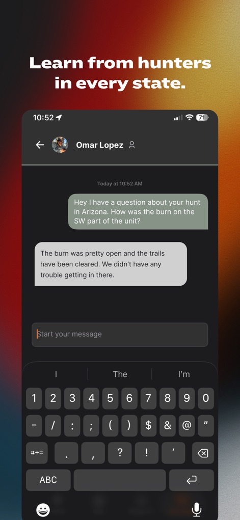
他のハンター「Omar Lopez」と直接メッセージを交換し、特定の狩猟地域に関する詳細な情報を得ることができます。この機能は、ユーザーが他のハンターから「unitの南西部での火災」や「トレイルの状態」について具体的なアドバイスを得るのに役立ちます。
ハンター間連携
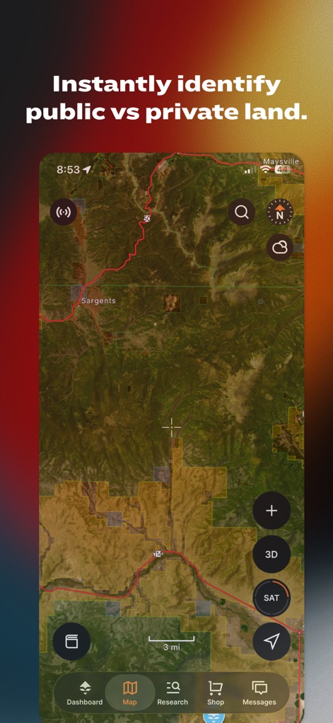
この地図は、公有地と私有地の境界線を色分けして明確に示しており、ユーザーは「SAT」ボタンで衛星ビューに切り替えることができます。これにより、狩猟可能なエリアを正確に特定し、計画を効率的に進められます。
公有地・私有地を判別

信号がない場所でもアクセス可能なこの地形図は、起伏のある地形と水系の詳細な情報を提供します。ユーザーは「GH TOPO」レイヤーを活用し、より詳細な「3D」ビューで地形を分析して、オフライン環境でも確実にナビゲーションを行えます。
オフラインでのナビゲーション

ユーザーは、グリズリーやオオカミの目撃情報を含む「Quick Tips」を閲覧し、「Species」や「General Size」、「Trophy Potential」といったカテゴリの包括的なデータを確認できます。これにより、特定の狩猟ユニットの特性を深く理解し、より効果的な計画を立てられます。
包括的なユニット分析

ユーザーは、各狩猟ユニットの具体的な「Draw Odds」パーセンテージを確認し、関連する「Apply by」日付を通じて申請期限を把握できます。この機能は、抽選に成功する可能性を最大限に高めるための戦略的な意思決定を支援します。
抽選成功率を予測
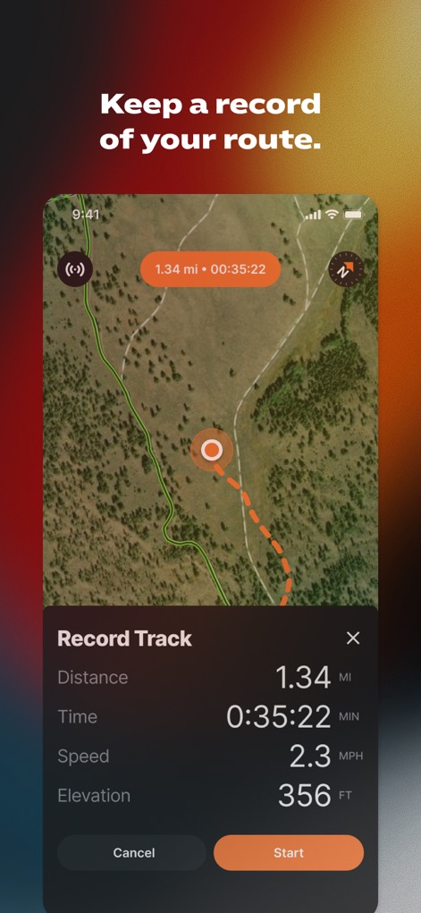
ユーザーは、狩猟中のルートを詳細に記録でき、「1.34 mi」の距離や「0:35:22」の経過時間といった具体的なデータを追跡できます。この機能により、過去の狩猟活動を振り返り、将来の計画に役立てることが可能です。
狩猟ルートを記録

ユーザーは、地図上に「Buck」や「Glassing」といった複数のウェイポイントを設定し、その詳細を仲間と共有できます。この機能は、作成されたウェイポイントリストに「日時」を表示し、チーム全体での狩猟計画と連携を円滑に進めることを可能にします。
チームで計画を立てる
説明
Download
類似アプリ
似た機能とユーザー体験を持つアプリ

onX Hunt: GPS Hunting Maps
onXmaps, Inc.

HuntWise: A Better Hunting App
Sportsman Tracker, Inc

HuntStand: GPS Maps & Tools
Good Sportsman Marketing, LLC

MyHunt: US Best Hunting App
Hunter & Companion Gesellschaft mit beschrankter Haftung

WeHunt
Natlink AB

DeerCast-Prep. Predict. Pursue
Good Sportsman Marketing, LLC

BaseMap: Hunting GPS Maps
BaseMap Inc

iHunter
Inside Outside Studios Inc.

Hunting Points: GPS & Hunt App
Fishing Points d.o.o.
このページはアプリまたはその開発者の公式ページではなく、情報提供および論評を目的として作成された独立した編集出版物です。明示的に別段の記載がない限り、アプリおよびその開発者は、MWM、Apple、Google Play、アプリのパブリッシャー、またはアプリの開発者と提携、承認、後援、認可、またはその他の公式的な関係はなく、このページのいかなる内容も、アプリがMWMのサービスを使用して開発されたことを意味するものではありません。すべての商標、ロゴ、スクリーンショット、その他のコンテンツはそれぞれの所有者の財産です。