このページはアプリまたはその開発者の公式ページではなく、情報提供および論評を目的として作成された独立した編集出版物です。明示的に別段の記載がない限り、アプリおよびその開発者は、MWM、Apple、Google Play、アプリのパブリッシャー、またはアプリの開発者と提携、承認、後援、認可、またはその他の公式的な関係はなく、このページのいかなる内容も、アプリがMWMのサービスを使用して開発されたことを意味するものではありません。すべての商標、ロゴ、スクリーンショット、その他のコンテンツはそれぞれの所有者の財産です。

HuntStand: GPS Maps & Tools
ハンターは獲物を追うのではなく、アプリが獲物をその足元に連れてくる。900万以上のダウンロードが示すのは、このアプリが単なるツールではなく、ゲームチェンジャーであるという事実だ。
ダウンロード
1M+ユーザー評価
評価数
59.4K開発元
カテゴリ
Sports対応言語
1最新バージョン
8.0.71サイズ
216.3 MBリリース日
2013年12月19日精密なマッピングと環境データで狩猟体験を向上させる主要ツール
HuntStand: GPS Maps & Tools アプリ機能分析
全国的な土地境界線情報
このアプリは、全米およびカナダの一部地域における土地の境界線を検索し、私有地と公有地の境界を視覚化することを可能にします。これにより、ユーザーは法的境界を尊重し、最適なハンティングエリアを特定できます。
高度なゲーム活動予測
本ツールは、ユーザーの正確な位置に基づいて、シロオジカ、エルク、ミュールジカ、クロオジカの15日間の活動予測を提供します。これにより、ユーザーは動物の行動パターンを予測し、狩猟計画を最適化できます。
HuntZone風向予測
この機能は、最大72時間先までの時間ごとの風向と風速を予測し、ユーザーの匂いが動物に与える影響を判断するのに役立ちます。これにより、ユーザーは効果的なアプローチ経路を計画できます。
高精度GPSマッピング
ユーザーは自身の位置を正確に追跡し、移動ルートを記録し、スタンド、ブラインド、その他の重要な地点をマーカーとして追加できます。本機能は、野外での効率的なナビゲーションと場所の記憶を支援します。
専用の発情期マップ
本アプリは、郡レベルでシロオジカ、エルク、ミュールジカ、クロオジカの発情期マップを提供し、各段階の詳細な日付を明示します。これにより、ユーザーは獲物の活動が最も活発な時期を正確に把握できます。
月次衛星画像更新
この機能は、毎月の衛星画像更新と過去数年間のアーカイブ画像を通じて、ハンティングエリアの環境変化をユーザーが監視することを可能にします。これにより、ユーザーは植生の変化や地形の状況を把握し、スカウト活動を改善できます。
無制限オフラインマップ
ユーザーはインターネット接続がない場所でも使用できるよう、無制限のマップを保存できます。本機能は、遠隔地での信頼性の高いナビゲーションと情報アクセスを保証します。
3Dマッピング機能
このツールは、地形をダイナミックな3Dで「フライスルー」する機能を提供し、ユーザーがハンティングエリアの起伏や隠蔽場所をより詳細に理解するのに役立ちます。これにより、ユーザーはより効果的なスカウト計画を立てることができます。
グループハンティングエリア共有
ユーザーはハンティングエリアを友人、リースパートナー、家族とシームレスに共有できます。本機能は、共同での計画立案と情報交換を促進し、チーム全体の成功を向上させます。
シロオジカ生息地マップ
この機能は、最適なシロオジカ生息地を特定するのに役立ちます(米国限定)。これにより、ユーザーは最も生産的なハンティングエリアに焦点を当て、成功の可能性を高めることができます。
よくある質問
について知っておくべきこと HuntStand: GPS Maps & Tools
Is HuntStand recognized as a top hunting app?
Yes, HuntStand is North America’s #1 Hunting & Land Management App. Outdoor Life Magazine recognized HuntStand as the Best App for Hunters.
Does HuntStand include property line maps?
Yes, HuntStand offers nationwide property lines, public and private boundaries, and public land maps for all 50 states and most of Canada.
How much does HuntStand Pro cost annually?
HuntStand Pro costs $29.99 per year. This premium membership provides advanced mapping tools and nationwide coverage, including property ownership data.
Can HuntStand access historical satellite imagery?
Yes, HuntStand provides monthly satellite imagery updates and archives years of historical imagery. This allows users to observe changes in their hunting grounds over time.
Does HuntStand include game activity forecasts?
Yes, HuntStand offers exclusive 15-day activity forecasts for whitetail, elk, mule deer, and blacktail, tailored to your exact location for optimal hunting strategy.
Is the HuntStand app free to download?
Yes, the HuntStand app is free to install. Users can download it and begin mapping their hunting areas today without any initial cost.
Where can I find HuntStand's privacy policy?
HuntStand's Privacy Policy is available for review at the provided URL: https://huntstand.com/privacy. This ensures transparency regarding data handling.
Can I share hunt areas with others using HuntStand?
Yes, HuntStand allows users to share hunt areas seamlessly with buddies, lease partners, and family, facilitating collaborative hunting and land management.
What is the annual price for HuntStand Ultimate?
HuntStand Ultimate costs $99.99 per year. This premium subscription includes all HuntStand Pro features plus exclusive tools like advanced rut maps and whitetail habitat maps.
Does HuntStand offer 3D mapping capabilities?
Yes, HuntStand Pro offers 3D mapping functionality. This feature allows users to 'fly through' terrain in dynamic 3D for enhanced scouting and planning.
以下のスクリーンショットと説明は、アプリの公式ストアリスティングから直接取得されたものであり、アプリ開発者の所有物です。
アプリストア
スクリーンショット
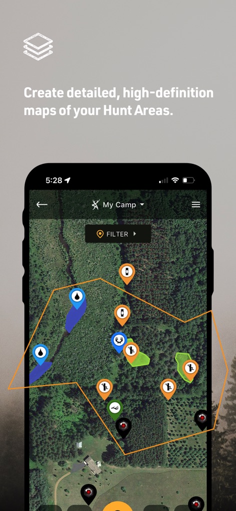
ユーザーは、このアプリで狩猟エリアの詳細な高精細マップを作成でき、ピンとポリゴンで重要な地点をマークできます。
マップをカスタマイズ

本アプリは、全50州の土地の所有者情報と境界線を検索可能にし、マップ上で強調表示された土地の境界線と、所有者名や住所などの詳細情報を提供します。
土地所有情報を検索

ユーザーは、アプリ内で何年にもわたる月ごとの衛星画像を閲覧でき、ドロップダウンメニューから特定の年と月を選択して過去の地形の変化を確認できます。
過去の衛星画像

本アプリは、Outdoor Life Magazineにより「最高の狩猟アプリ」として評価されており、タイトルと4.5の星評価でその高いユーザー満足度を示しています。
最高の狩猟アプリ
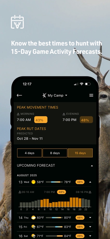
本ツールは、15日間の詳細な動物の活動予測を提供し、日ごとの天気予報と時間ごとの活動量を示すグラフで最適化された狩猟計画を支援します。
活動予測で成功

ユーザーは、強力なホワイトテールマップ上で郡ごとの発情期のデータを視覚的に確認でき、色分けされたヒートマップと具体的な日付情報で最適な狩猟時期を特定できます。
発情期の地図

本アプリは、GEARJUNKIE.COMから「土地所有者にとって最高の狩猟アプリ」と評価されており、引用符で囲まれた評価文と提供元のロゴが信頼性を高めます。
土地所有者に最適

このアプリは、狩猟地と新しい場所を視覚的に特定するのに役立ち、マップ上の黄色いハイライトと下部に表示される土地の詳細情報を提供します。
新しい狩猟地を発見

ユーザーは、高度なリアル3Dマッピングで地形を立体的に偵察でき、多種多様なピンとトレイルパスで狩猟エリアの詳細な視覚化が可能です。
進化した3Dマッピング

本ツールは、現在の気象状況から10日間の天気予報までを提供し、日ごとの気温と天候アイコンで詳細な情報を表示します。
天気予報と状況
説明
Download
類似アプリ
似た機能とユーザー体験を持つアプリ

onX Hunt: GPS Hunting Maps
onXmaps, Inc.

GOHUNT: Research & Maps
GOHUNT, LLC

HuntWise: A Better Hunting App
Sportsman Tracker, Inc

MyHunt: US Best Hunting App
Hunter & Companion Gesellschaft mit beschrankter Haftung

WeHunt
Natlink AB

DeerCast-Prep. Predict. Pursue
Good Sportsman Marketing, LLC

BaseMap: Hunting GPS Maps
BaseMap Inc

iHunter
Inside Outside Studios Inc.

Hunting Points: GPS & Hunt App
Fishing Points d.o.o.
このページはアプリまたはその開発者の公式ページではなく、情報提供および論評を目的として作成された独立した編集出版物です。明示的に別段の記載がない限り、アプリおよびその開発者は、MWM、Apple、Google Play、アプリのパブリッシャー、またはアプリの開発者と提携、承認、後援、認可、またはその他の公式的な関係はなく、このページのいかなる内容も、アプリがMWMのサービスを使用して開発されたことを意味するものではありません。すべての商標、ロゴ、スクリーンショット、その他のコンテンツはそれぞれの所有者の財産です。