このページはアプリまたはその開発者の公式ページではなく、情報提供および論評を目的として作成された独立した編集出版物です。明示的に別段の記載がない限り、アプリおよびその開発者は、MWM、Apple、Google Play、アプリのパブリッシャー、またはアプリの開発者と提携、承認、後援、認可、またはその他の公式的な関係はなく、このページのいかなる内容も、アプリがMWMのサービスを使用して開発されたことを意味するものではありません。すべての商標、ロゴ、スクリーンショット、その他のコンテンツはそれぞれの所有者の財産です。

onX Hunt: GPS Hunting Maps
広大な荒野で、このアプリはあなたに千里眼を与える。獲物の動きを読み、地形を支配し、決して道に迷うことはない。それは単なる地図ではなく、狩猟の未来なのだ。
ダウンロード
10M+ユーザー評価
評価数
276.4K開発元
カテゴリ
Navigation対応言語
1最新バージョン
26.13.0サイズ
496.8 MBリリース日
2013年8月7日精密な狩猟計画と現場実行を支援する主要機能の評価
onX Hunt: GPS Hunting Maps アプリ分析
詳細な地理空間情報とマッピング
本アプリは、衛星画像、Lidar地形図、ハイブリッドベースマップ、3Dマップ、全国の土地境界線(私有地/公有地、GMU、ハンティングユニット)を提供し、ハンターが綿密な計画を立て、地形を正確に理解することを可能にします。
オフライン対応GPSナビゲーションと現場実行ツール
このアプリは、オフラインマップ、内蔵GPS、コンパスモード、追跡機能、局所的な気象予報を提供し、インターネット接続がない場所でも、ハンターが目的地を正確に把握し、安全かつ効率的に行動できるよう支援します。
エリート会員向け独占ツール
アプリは、TerrainX 3Dビューア、最新画像、ルートビルダー、鹿の移動予測といった高度なツールを提供し、上級ハンターが詳細な洞察と戦略的な計画能力を獲得し、狩猟の成功を最大化することを支援します。
土地所有権と境界線情報
このツールは、米国内の私有地の境界線と所有者名、ならびに公有地および州有地の狩猟地図を提供し、ハンターが法的な狩猟区域を正確に特定し、土地侵入のリスクを回避することを支援します。
高度な狩猟計画とリサーチツール
本アプリは、抽選確率、タグのトレンド、捕獲統計、専門家のリサーチ情報、アプリケーション期限のリマインダーを提供し、ハンターがデータに基づいた戦略的な計画を立て、成功の可能性を高めることを可能にします。
カスタムマップレイヤーと地形分析
このアプリは、州固有のマップレイヤーを通じて、地形分析、条件、アクセスポイント、野生生物、樹木、土壌などの詳細な情報を提供し、ハンターが自身のニーズに合わせてマップをカスタマイズし、特定の狩猟タグを効果的にスカウトできるよう支援します。
外部デバイスとのシームレスな連携
アプリは、トレイルカメラ、距離計、双眼鏡、Apple CarPlay、Apple Watchなどの互換性のあるデバイスと連携し、現場での情報収集とナビゲーションを強化し、ハンターのワークフローを効率化します。
コラボレーションと共有機能
このツールは、マップマークアップ、狩猟エリア、追跡経路を他のユーザーと共有する機能を提供し、グループでの狩猟計画や連携を容易にし、効率的なチームワークを促進します。
よくある質問
について知っておくべきこと onX Hunt: GPS Hunting Maps
What is onX Hunt?
onX Hunt is a GPS hunting app designed for planning hunts and navigating in the field. It provides species distribution, 3D maps, hunting units, and nationwide land boundaries.
Does onX Hunt show private land boundaries?
Yes, onX Hunt provides access to private land boundary data and property line maps, including landowner names, for U.S. states where available.
Can I use onX Hunt without cell service?
Yes, onX Hunt allows users to save detailed Offline Maps. This feature enables navigation and map use in areas without cell service.
What types of maps does onX Hunt offer?
onX Hunt offers satellite, lidar topo, and hybrid Basemaps. Users can view terrain in both 2D and 3D, and save custom Offline Maps.
How do I get a free trial for onX Hunt?
Users can start a seven-day free trial of onX Hunt by installing the app and selecting their desired state within the application.
Does onX Hunt integrate with trail cameras?
Yes, onX Hunt integrates with compatible tools such as Moultrie trail cameras. Users can view images in real-time and receive key insights.
What is the Elite Nationwide Membership for onX Hunt?
The Elite Nationwide Membership for onX Hunt offers proprietary maps for all 50 states and Canada, TerrainX 3D Viewer, Route Builder, and Elite-exclusive pro deals.
Can onX Hunt display wind conditions?
Yes, onX Hunt allows users to monitor weather and set optimal wind conditions on any Waypoint. It provides forecasts and a wind calendar.
How does onX Hunt help identify hunting areas?
onX Hunt helps identify new hunting areas by targeting nutrient-rich soil with its Historic Wildfire Layer and using custom Map Layers for wildlife distribution, trees, crops, or soil.
What are the GPS tools available in onX Hunt?
onX Hunt provides GPS tools to mark Waypoints, track progress, measure distances, and calculate area shapes. It also includes features like Line Distance and Compass Mode.
以下のスクリーンショットと説明は、アプリの公式ストアリスティングから直接取得されたものであり、アプリ開発者の所有物です。
アプリストア
スクリーンショット
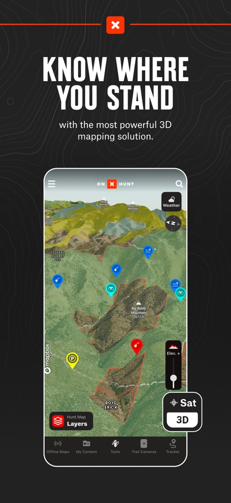
ユーザーは強力な3Dマッピングソリューションで地形を視覚化できます。この画面では、色分けされたプロットと「Sat 3D」オプションで詳細な等高線データが表示されています。
3Dマップナビゲーション

詳細な私有地の境界線と所有者情報を確認できます。マップ上のプロットと「Owner: TP FARMS LLC」の表示で土地の所有権が明確に示されています。
私有地情報表示

BLMや国立森林地帯などの公有地境界線を視覚化できます。この画面では、異なる公共の土地タイプが色分けされた境界線と「Hunt Map Layers」ボタンで強調されています。
公有地境界線
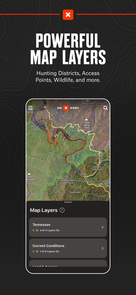
ユーザーは狩猟地区、アクセスポイント、野生生物などの多様な情報レイヤーを適用できます。表示されているマップには「Map Layers」メニューから選択可能な「Tennessee」と「Current Conditions」のレイヤーが含まれています。
高機能マップレイヤー
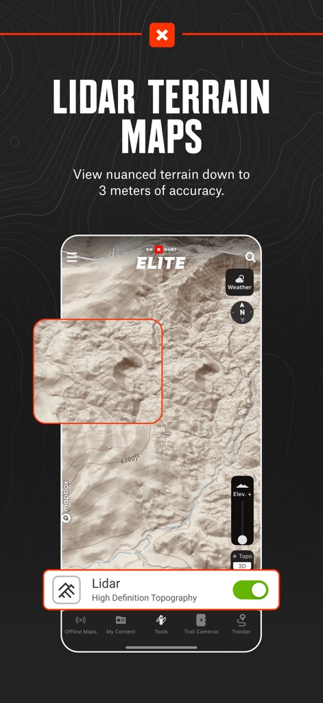
3メートル精度で地形の微妙な変化を詳細に把握できます。このスクリーンショットは、ズームされたLidarマップの「Lidar High Definition Topography」スイッチがオンになっている様子を示しています。
高精細LIDAR地形

各ウェイポイントに最適な風向き条件を設定し、詳細な天気予報を確認できます。マップ上には「11 NW Good Wind」と記されたウェイポイントと、日ごとの風の予報を示す「Wind Calendar」が表示されています。
風と気象情報

ウェイポイントをマークし、移動経路を追跡し、距離を測定するツールを利用できます。画面下部の「Tools」メニューには「Add Waypoint」や「Line Distance」などの機能がリストされています。
精密GPSツール

電波の届かない場所でも使用できるよう、マップデータをダウンロードできます。この画面では、ユーザーが選択した「Offline Map」のダウンロード範囲と、詳細レベルの選択肢(「Topo」や「High」など)が示されています。
オフラインマップ

どんぐりを生産するオークなどの特定の樹種を特定し、獲物の生息地を分析できます。マップ上には異なる樹種が色分けで表示されており、「Acorn Producing Oaks」の切り替えオプションが利用可能です。
樹種マップ
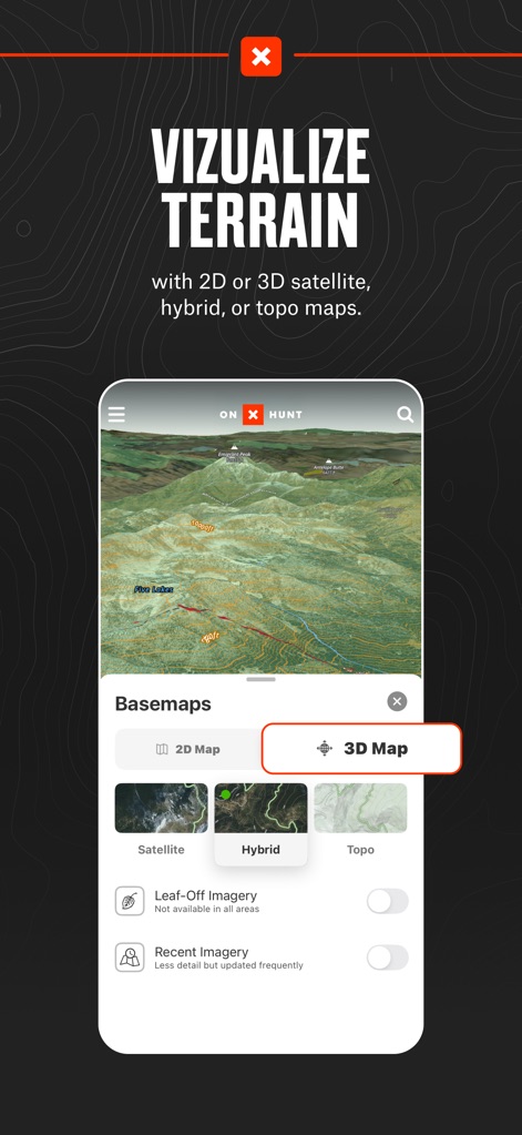
衛星、ハイブリッド、地形図などのベースマップで、2Dまたは3Dで地形を視覚化できます。この画面では、「Basemaps」メニューで「3D Map」が選択され、詳細な地形が立体的に表示されています。
地形を視覚化
説明
Download
類似アプリ
似た機能とユーザー体験を持つアプリ

GOHUNT: Research & Maps
GOHUNT, LLC

HuntWise: A Better Hunting App
Sportsman Tracker, Inc

HuntStand: GPS Maps & Tools
Good Sportsman Marketing, LLC

MyHunt: US Best Hunting App
Hunter & Companion Gesellschaft mit beschrankter Haftung

WeHunt
Natlink AB

DeerCast-Prep. Predict. Pursue
Good Sportsman Marketing, LLC

BaseMap: Hunting GPS Maps
BaseMap Inc

iHunter
Inside Outside Studios Inc.

Hunting Points: GPS & Hunt App
Fishing Points d.o.o.
このページはアプリまたはその開発者の公式ページではなく、情報提供および論評を目的として作成された独立した編集出版物です。明示的に別段の記載がない限り、アプリおよびその開発者は、MWM、Apple、Google Play、アプリのパブリッシャー、またはアプリの開発者と提携、承認、後援、認可、またはその他の公式的な関係はなく、このページのいかなる内容も、アプリがMWMのサービスを使用して開発されたことを意味するものではありません。すべての商標、ロゴ、スクリーンショット、その他のコンテンツはそれぞれの所有者の財産です。