このページはアプリまたはその開発者の公式ページではなく、情報提供および論評を目的として作成された独立した編集出版物です。明示的に別段の記載がない限り、アプリおよびその開発者は、MWM、Apple、Google Play、アプリのパブリッシャー、またはアプリの開発者と提携、承認、後援、認可、またはその他の公式的な関係はなく、このページのいかなる内容も、アプリがMWMのサービスを使用して開発されたことを意味するものではありません。すべての商標、ロゴ、スクリーンショット、その他のコンテンツはそれぞれの所有者の財産です。

Moultrie
トレイルカメラの写真を実用的なインテリジェンスに。業界で最も信頼されている狩猟エコシステムを使用して、セルラーカメラの管理、フィーダーの監視、そして風の把握を実現します。
ダウンロード
1M+ユーザー評価
評価数
28K+開発元
カテゴリ
Sports対応言語
-最新バージョン
6.0.0サイズ
171.5 MBリリース日
2016年4月20日データ主導のスカウティングで森を制する
トレイルカメラ管理、群れの情報、狩猟計画のための業界最先端のエコシステムで、フィールドでの限られた時間を最大限に活用しましょう。
AI搭載の画像インテリジェンス
何千枚もの写真を手作業で仕分けるのはもうやめましょう。スマートタグが雄鹿、雌鹿、七面鳥を自動的に識別し、雄鹿の年齢まで推定することで、正確な群れ管理をサポートします。
予測に基づいたゲームプラン
勘に頼るのをやめて、狩猟を始めましょう。過去の目撃情報、月相、気圧を利用して活動のピーク時間を予測し、仕事を休むべき最適な日を正確に把握できます。
よくある質問
について知っておくべきこと Moultrie
Moultrieアプリとは何ですか?
Moultrieアプリは、包括的な狩猟計画ツールであり、接続された狩猟エコシステムです。トレイルカメラの管理、フィーダーの制御、データに基づいた洞察による狩猟計画を支援し、トレイルカメラの写真を見る以上の機能を提供します。
Moultrieアプリは無料の狩猟計画ツールを提供していますか?
はい、Moultrieアプリは、カメラやサブスクリプションなしで、インタラクティブマップ、フォトライブラリ、画像整理用のスマートタグ、アクティビティチャート、天気予報などの無料の狩猟計画ツールを提供しています。
Moultrieアプリでトレイルカメラをリモートで管理できますか?
はい、Moultrieアプリを使用すると、セルラートレイルカメラのリモート管理が可能です。ユーザーは、どこからでも即座に通知を受け取り、写真/ビデオのオンデマンドリクエストを行い、カメラ設定を調整できます。
Moultrieアプリのスマートタグは、どのような種類の画像を自動的に識別できますか?
Moultrieアプリのスマートタグは、雄鹿、雌鹿、七面鳥、その他の種の画像を自動的に識別して整理します。また、効率的な分析のために雄鹿を年齢別にソートします。
Moultrieアプリは、狩猟のための風予報をどのように支援しますか?
Moultrieアプリは、理想的な風予報機能を提供します。ユーザーは、スタンドの好みの風向を設定し、リアルタイムおよび7日間の風予報を受け取って、より賢く狩猟を計画し、検出されないようにすることができます。
Moultrieアプリには敷地境界線情報が含まれていますか?
はい、Moultrieアプリは、高度な狩猟計画ツールとしてTopo + Property Linesを提供します。この機能は、土地所有者データと地形オーバーレイを備えた公有地と私有地の境界を表示します。
アプリを使用してMoultrieフィーダーをリモートで制御できますか?
はい、Moultrieアプリを使用すると、Bluetoothまたはセルラー経由で接続されたフィーダーをリモートで制御できます。ユーザーは、フィードレベルを確認し、スケジュールを調整し、オンデマンドで給餌し、問題に関するアラートを受け取ることができます。
Moultrieアプリは、鹿の移動を予測するのにどのように役立ちますか?
Moultrieアプリのゲームプラン機能は、鹿の高い活動期間を予測します。地元のトレイルカメラの目撃情報と天気データを活用して、狩猟に最適な時間とフィールド時間の最大化を予測します。
Moultrieアプリはどのような種類のアクティビティデータを提供しますか?
Moultrieアプリは、動物の目撃パターンを特定するアクティビティチャートを提供します。一日の時間、月の位相、気温別のアクティビティを表示し、ターゲットの動物が最も活発な時間を示します。
以下のスクリーンショットと説明は、アプリの公式ストアリスティングから直接取得されたものであり、アプリ開発者の所有物です。
アプリストア
スクリーンショット
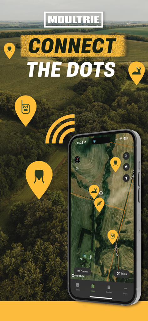
カメラと野生動物の目撃情報のピンが表示された、スマートフォンのインタラクティブな狩猟マップを示すMoultrieアプリのインターフェース
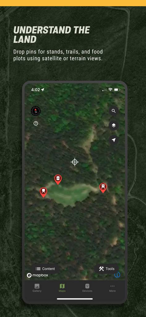
狩猟待機場所とトレイルのピンが表示された、衛星マップビューを示すMoultrieモバイルアプリ
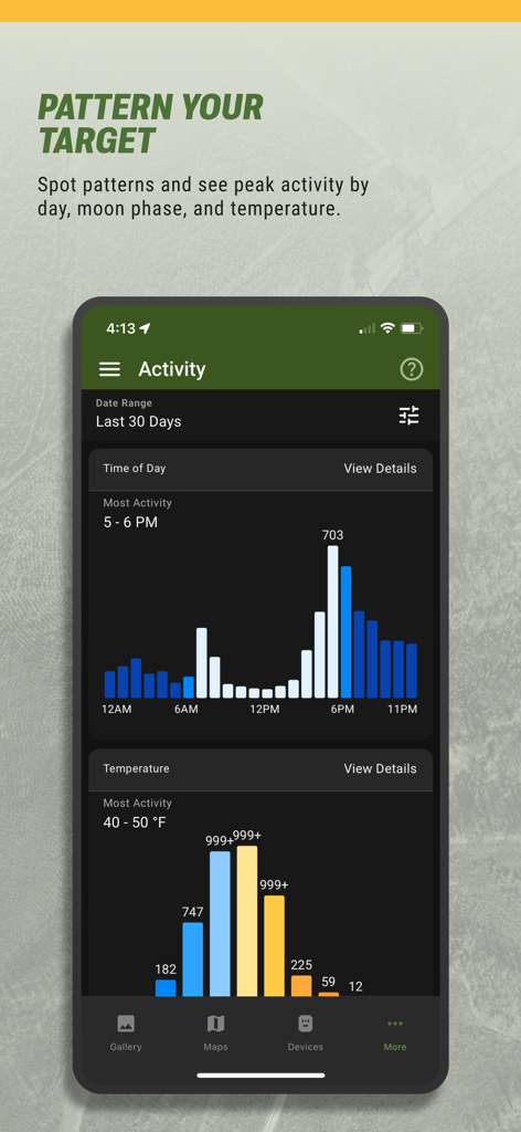
時間帯と気温別の鹿の活動チャートを示すモバイルアプリの画面
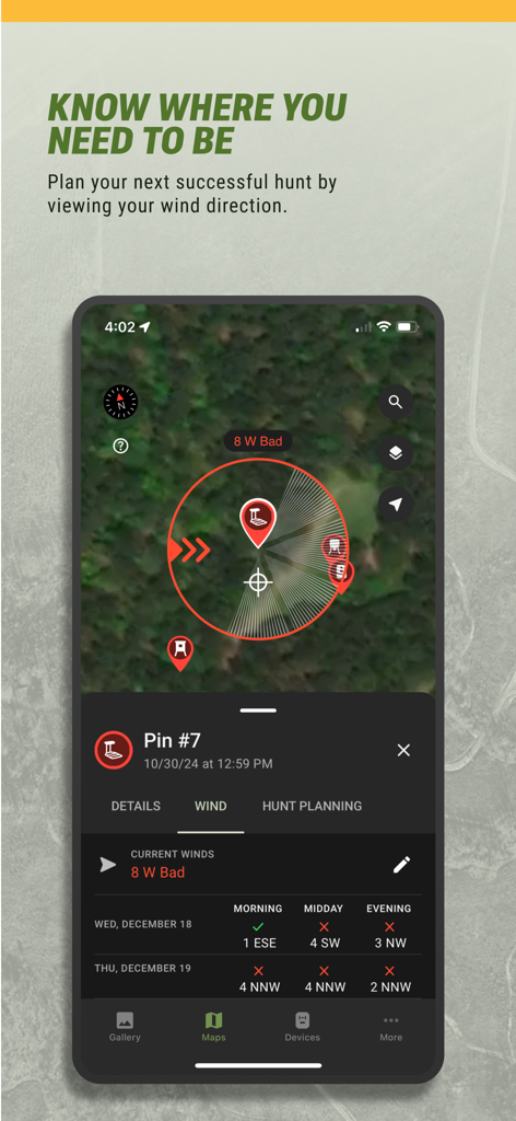
衛星マップ上に風向と狩猟予測を表示するMoultrieアプリのインターフェース
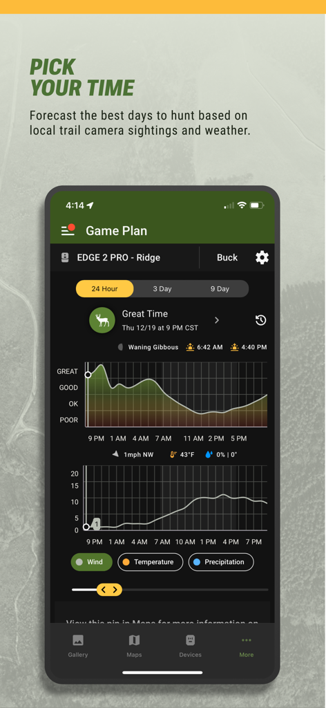
気象と月相データを含む鹿の活動予測チャートを表示する、Moultrieアプリのゲームプラン機能のスクリーンショット
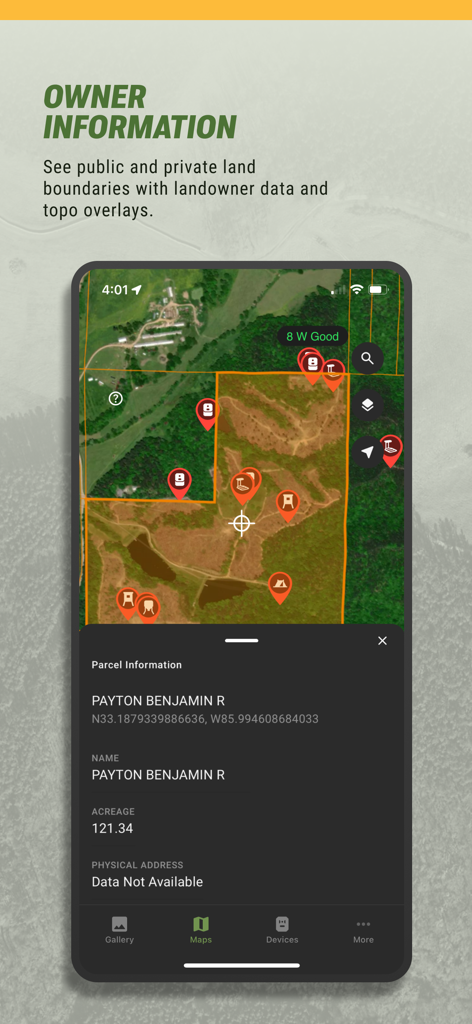
衛星マップ上に敷地境界線と地主情報を表示するMoultrieアプリのインターフェース
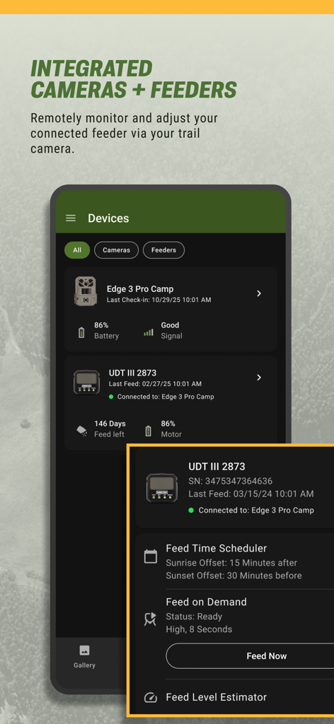
トレイルカメラと自動フィーダーのリモート管理のためのMoultrieアプリのインターフェース
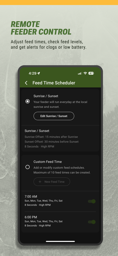
狩猟用フィーダーをリモートで管理するためのMoultrieアプリの給餌時間スケジューラーを示すスマートフォンの画面
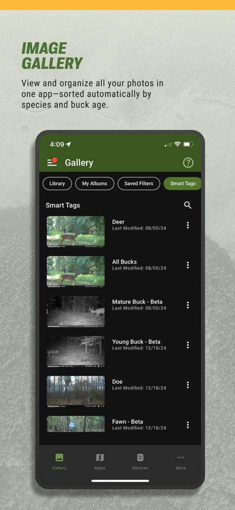
鹿の種別と雄鹿の年齢分類のための自動スマートタグを表示する、Moultrieアプリの画像ギャラリーのスクリーンショット
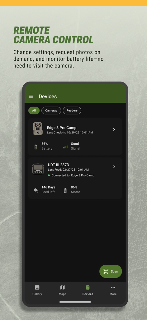
バッテリーと信号レベルを表示する、リモートカメラおよびフィーダー管理用のMoultrieアプリのインターフェース
説明
Download
類似アプリ
似た機能とユーザー体験を持つアプリ

onX Hunt: GPS Hunting Maps
onXmaps, Inc.

GOHUNT: Research & Maps
GOHUNT, LLC

HuntWise: A Better Hunting App
Sportsman Tracker, Inc

HuntStand: GPS Maps & Tools
Good Sportsman Marketing, LLC

MyHunt: US Best Hunting App
Hunter & Companion Gesellschaft mit beschrankter Haftung

WeHunt
Natlink AB

DeerCast-Prep. Predict. Pursue
Good Sportsman Marketing, LLC

BaseMap: Hunting GPS Maps
BaseMap Inc

iHunter
Inside Outside Studios Inc.
このページはアプリまたはその開発者の公式ページではなく、情報提供および論評を目的として作成された独立した編集出版物です。明示的に別段の記載がない限り、アプリおよびその開発者は、MWM、Apple、Google Play、アプリのパブリッシャー、またはアプリの開発者と提携、承認、後援、認可、またはその他の公式的な関係はなく、このページのいかなる内容も、アプリがMWMのサービスを使用して開発されたことを意味するものではありません。すべての商標、ロゴ、スクリーンショット、その他のコンテンツはそれぞれの所有者の財産です。