このページはアプリまたはその開発者の公式ページではなく、情報提供および論評を目的として作成された独立した編集出版物です。明示的に別段の記載がない限り、アプリおよびその開発者は、MWM、Apple、Google Play、アプリのパブリッシャー、またはアプリの開発者と提携、承認、後援、認可、またはその他の公式的な関係はなく、このページのいかなる内容も、アプリがMWMのサービスを使用して開発されたことを意味するものではありません。すべての商標、ロゴ、スクリーンショット、その他のコンテンツはそれぞれの所有者の財産です。

Spyglass
退屈な地図アプリが過去の遺物となる。Spyglassは、どんな荒野でもあなたの目を拡張し、必要なすべての情報をリアルタイムで提供する。これにより、ユーザーは環境を完全に支配する。
ダウンロード
500k+ユーザー評価
評価数
6.4K開発元
カテゴリ
Navigation対応言語
12最新バージョン
3.31.5サイズ
66.1 MBリリース日
2009年10月4日高度なオフラインナビゲーションツールの詳細評価
「Spyglass」の主要機能分析
強力なオフライン地図
ユーザーは、インターネット接続がない環境でも、多様な地図スタイルとプロバイダーを利用して、自身の位置や目標の位置を地図上で確認できます。ウェイポイントの計画や距離の測定が可能です。
高度なオフラインGPSナビゲーション
困難なオフグリッド環境下でも、ユーザーは正確な位置特定と経路追跡が可能です。カスタム地点の保存と精密なナビゲーションを提供します。
拡張現実 (AR) ファインダーとトラッキング
本ツールは、拡張現実技術を介してカメラや地図上にリアルタイムの対象物の位置、情報、方向を重ねて表示します。複数の目標を同時に追跡し、距離、方向、方位、高度、到着予定時刻などの詳細情報を提供します。
高精度コンパスとジャイロコンパス
このアプリは、独自の精度向上技術とキャリブレーション方法により、極めて正確な方位情報を提供し、困難な地形での方向特定を支援します。
詳細なGPSデータと計測器
このアプリは、数十種類の形式での座標、高度、進路、現在・最高・垂直速度など、包括的なリアルタイムGPSデータを提供し、様々な単位系に対応します。
天体追跡とナビゲーション
本ツールは、太陽、月、星の位置を秒単位の精度で追跡し、コンパスの校正や代替のナビゲーション手段として利用できます。
精密な光学距離測定
このアプリは、スナイパーサイトのような距離計レチクルを使用して、対象物までの距離をリアルタイムで測定する機能を提供します。
高度な測定ツール
ユーザーは、目視測定に基づいて対象物の高さや距離を算出し、寸法と距離を詳細に計算することができます。
よくある質問
について知っておくべきこと Spyglass
What is Spyglass?
Spyglass is an essential offline GPS app for outdoors and off-road navigation. It provides numerous tools including a hi-tech compass, offline maps, GPS receiver, altimeter, and augmented reality features.
Does Spyglass work offline?
Yes, Spyglass operates as an offline GPS app. It provides offline maps optimized for retina displays, which users can download for navigation without an internet connection.
What navigation tools are included in the Spyglass app?
Spyglass includes a hi-tech compass, gyrocompass, GPS receiver, waypoint tracker, speedometer, altimeter, optical rangefinder, sextant, inclinometer, and a Sun, Moon, and star finder. It also features augmented reality.
Can Spyglass track stars, the Sun, and the Moon?
Yes, Spyglass tracks the positions of stars, the Sun, and the Moon with arc second precision. Users can utilize these celestial bodies to calibrate the compass for maximum accuracy.
How does Spyglass use augmented reality (AR)?
Spyglass operates in 3D and uses augmented reality to display real-time object positions, information, and directions. It overlays this data directly over the camera view or maps.
Can I save custom locations in Spyglass?
Yes, Spyglass allows users to save current positions, add points from maps, and manually enter location coordinates. It also offers a built-in star catalog for saving celestial objects.
What kind of GPS data does Spyglass display?
Spyglass displays detailed real-time GPS data including coordinates in dozens of formats, altitude, course, current, maximum, and vertical speed. It supports imperial, metric, nautical, and surveying units.
Does Spyglass offer different unit measurements?
Yes, Spyglass supports various unit measurements. Users can select imperial, metric, nautical, and surveying units for speed, distance, and other GPS data, configurable in settings.
What is Spyglass PLUS?
Spyglass PLUS is an enhanced version offering specific map sources tailored for activities like hiking, cycling, and skiing. It is available as a subscription.
How do I manage my Spyglass PLUS subscription?
You can turn off automatic renewal for Spyglass PLUS at any time in your iTunes Account Settings after purchase. The subscription expires at the end of the current period upon cancellation.
Can Spyglass measure distances to objects?
Yes, Spyglass features an optical rangefinder to measure distances to objects in real-time, using a reticle similar to sniper sights. It also offers a sextant for visual distance and dimension calculations.
Does Spyglass allow sharing of locations?
Yes, Spyglass allows users to copy, paste, and share locations, coordinates, and map links. It supports multiple formats for convenient sharing.
以下のスクリーンショットと説明は、アプリの公式ストアリスティングから直接取得されたものであり、アプリ開発者の所有物です。
アプリストア
スクリーンショット

この画面では、詳細なオフライン地図上に現在の方向が重ねて表示され、ユーザーの進行方向と周囲の都市環境が明確に示されています。また、画面上部にはリアルタイムの速度と高度が表示され、現在の移動状況を正確に把握できます。
高度な地図表示
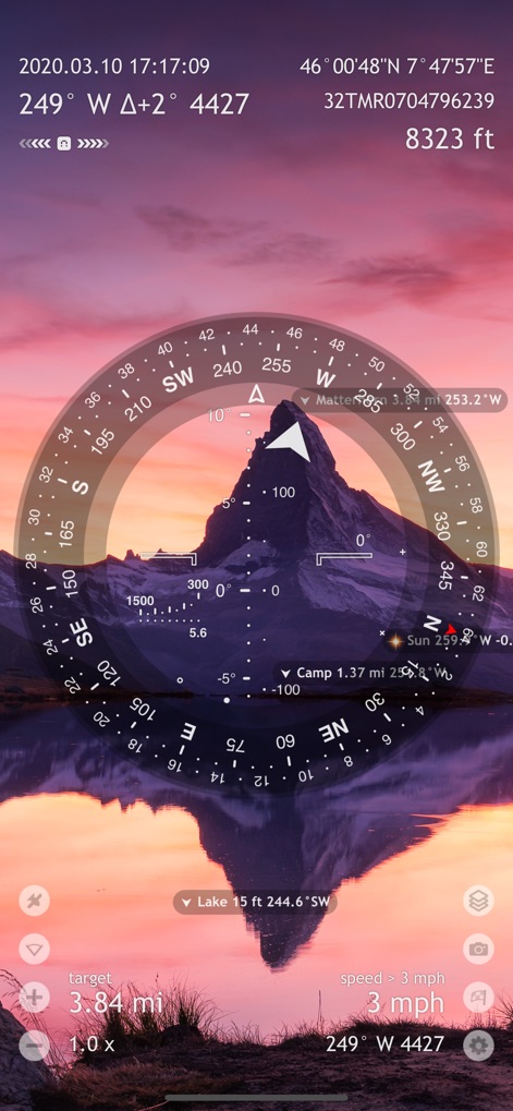
広大な山岳風景を背景に、拡張現実(AR)機能がコンパスリング上に統合されており、ユーザーは目の前の景色とナビゲーション情報を同時に確認できます。遠方にある目標地点「Matterhorn」への方向が明確に示されており、周囲の環境と連動した精密な誘導を可能にします。
ARで目標を捕捉

広大な森林地帯の衛星画像上にコンパスオーバーレイが表示され、ユーザーは地形を把握しながら進路を決定できます。画面下部には「Jeep」や「Antenna #1」といった複数のカスタムウェイポイントが表示され、複雑な環境での正確な位置特定と目標追跡をサポートします。
地図とウェイポイント

暗い背景に明るいコンパスと情報が表示されるナイトモードは、低照度環境での視認性を最大限に高めます。この画面では、太陽と月の現在の位置が明確に示され、ユーザーは天体を利用した方角確認やコンパスのキャリブレーションを実行できます。
夜間ナビゲーション

高低差を示す等高線が描かれた詳細な地形図が背景に表示され、ユーザーは周辺の地形を正確に把握できます。コンパスオーバーレイとともに、「Eibsee」や「Zugspitze」などの地点情報も組み合わされ、高山環境でのルート計画とナビゲーションを支援します。
高精度な地形情報

「Destinations」画面では、ユーザーは「Decoy」や「Camp」といったカスタムウェイポイントに加え、「Aldebaran」や「Betelgeuse」のような天体も目的地として登録し、管理できます。これにより、個別のニーズに応じた多様な目標設定と追跡が可能になります。
目的地管理

満天の星空を背景に、ベテルギウスやリゲル、ベラトリックスといった複数の星がリアルタイムで追跡され、コンパス上にその位置と方角が表示されます。この機能により、ユーザーは天体を利用して正確な方位を特定し、夜間やオフグリッド環境でのナビゲーションに役立てることができます。
天体追跡システム

ダッシュボード画面では、緯度/経度、高度、方位角、速度、垂直速度といった詳細なGPSデータが大きく表示され、ユーザーは現在の状況を一目で把握できます。それぞれのデータには精度情報も付随しており、ユーザーは極めて正確な位置情報と移動状況を確認できます。
精密なGPSデータ

「Satellites」画面では、現在捕捉している39個の衛星が円形のレーダービューに表示され、ユーザーは空における衛星の配置を視覚的に確認できます。下部のバーグラフは各衛星の信号強度(SNR)を示しており、ユーザーは受信品質をリアルタイムで監視できます。
衛星追跡と信号

「Settings」画面では、「Metric units」や「Nautical miles」といった測定単位の切り替えや、「Milspec units」の有効化など、ユーザーは自身のニーズに合わせて単位を細かくカスタマイズできます。また、「Destinations」や「Maximum tracking range」といったナビゲーション機能に関する詳細設定も行え、アプリの動作を最適化できます。
高度な設定調整
説明
Download
類似アプリ
似た機能とユーザー体験を持つアプリ

AllTrails: Hike, Bike & Run
AllTrails, Inc.

Pedometer++
Cross Forward Consulting, LLC

Organic Maps: Offline Map
Organic Maps OU

Gaia GPS: Mobile Trail Maps
Trailbehind, INC.

Offline hiking maps: Mapy.com
Seznam.cz a.s.

Hiking Map Poland
Mapa Turystyczna sp. z o.o.

MapOut
Valnova GmbH

FarOut: Offline GPS Trail Maps
Atlas Guides DE, Inc.

Norgeskart
Norgeskart AS
このページはアプリまたはその開発者の公式ページではなく、情報提供および論評を目的として作成された独立した編集出版物です。明示的に別段の記載がない限り、アプリおよびその開発者は、MWM、Apple、Google Play、アプリのパブリッシャー、またはアプリの開発者と提携、承認、後援、認可、またはその他の公式的な関係はなく、このページのいかなる内容も、アプリがMWMのサービスを使用して開発されたことを意味するものではありません。すべての商標、ロゴ、スクリーンショット、その他のコンテンツはそれぞれの所有者の財産です。