This page is not an official page of the app or its developer, but an independent editorial publication created for informational and commentary purposes. Unless expressly stated otherwise, neither the app nor its developer is affiliated with, endorsed by, sponsored by, authorized by, or otherwise officially connected with MWM, Apple, Google Play, the app publisher, or the app's developer, and nothing on this page implies that the app was developed using MWM's services. Any trademarks, logos, screenshots, and other content remain the property of their respective owners.

bergfex: Hiking & Tracking
Master the terrain with topographic precision, advanced safety tools, and seamless data sync for the serious outdoor athlete. From the Rockies to the Alps, navigate off-grid with confidence.
Downloads
2M+User Rating
Total Ratings
32K+Publisher
Category
NavigationLocales
15Latest Version
4.9.20Size
227.6 MBFirst Released
Sep 25, 2015Professional Tools for Every Expedition
Experience the gold standard of mountain navigation. From technical backcountry skiing to Alpine trekking, our precision tools keep you safe and informed where ordinary maps fail.
Technical Safety Overlays
Navigate challenging terrain with slope steepness indicators and receive instant alerts if you drift off-track, ensuring safety in the backcountry.
Elite 3D Topography
Visualize your route with high-resolution 3D maps and official Alpine map material, fully accessible offline for off-grid adventures.
Frequently Asked Questions
Everything you need to know about bergfex: Hiking & Tracking
What is the bergfex: Hiking & Tracking app?
The bergfex: Hiking & Tracking app is for planning and tracking outdoor activities like hiking, ski tours, running, and mountain biking. It offers precise GPS navigation, detailed maps, and a route planner.
How do I create a custom route with bergfex: Hiking & Tracking?
Yes, the bergfex: Hiking & Tracking app includes a tour planner. Users create personal hikes in a few steps and receive precise GPS navigation to their destination. This feature ensures personalized route guidance.
Can I use bergfex: Hiking & Tracking maps offline?
Yes, the bergfex: Hiking & Tracking PRO subscription provides offline map material. This feature allows users to navigate safely without an active internet connection, which is essential for remote outdoor activities.
What map sources does bergfex: Hiking & Tracking use?
The bergfex: Hiking & Tracking app uses OpenStreetMap (OSM) for the entire European Alpine region. These maps are regularly updated, providing accurate and detailed topographic information for navigation.
What activity metrics does bergfex: Hiking & Tracking track?
The bergfex: Hiking & Tracking app tracks distance covered, duration, altitude meters, elevation profile, and speed for activities like hiking and ski touring. It also visualizes recorded activities with a heat map.
Is there a free trial for bergfex: Hiking & Tracking PRO features?
Yes, users can test all PRO functions of the bergfex: Hiking & Tracking app for 7 days free of charge. This trial requires registration within the app but comes without any commitment.
Can bergfex: Hiking & Tracking identify mountain peaks in real time?
Yes, the bergfex: Hiking & Tracking PRO subscription includes the "Peak Names" feature. This identifies surrounding mountain peaks and displays their names and altitudes directly within the app's view.
What integrations does bergfex: Hiking & Tracking support?
bergfex: Hiking & Tracking synchronizes tracked activities with Apple Health, Garmin Connect, and Polar Flow. The app also supports exporting and importing self-created routes via GPX files.
Does bergfex: Hiking & Tracking provide weather information?
Yes, the bergfex: Hiking & Tracking PRO subscription offers an animated display of rain fronts in your area. It also provides access to over 9,500 webcams for live regional insights.
Does bergfex: Hiking & Tracking have a safety warning for route deviations?
Yes, the bergfex: Hiking & Tracking PRO subscription includes a warning signal. This feature alerts users immediately when they leave the planned route, enhancing safety during outdoor activities.
The following screenshots and description are sourced directly from the app's official store listing and are the property of the app developer.
App Store
Screenshots
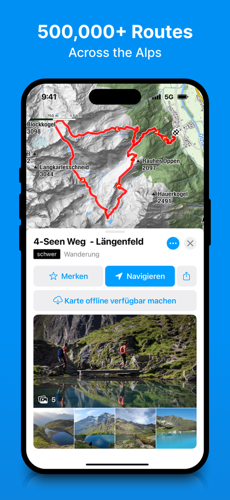
Smartphone screen showing a detailed hiking route and topographic map in the bergfex app
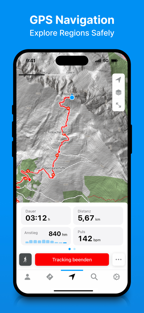
bergfex app displaying a topographic map with a hiking route and real time tracking statistics
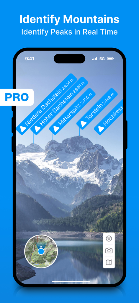
Smartphone screen showing bergfex app identifying mountain peaks in real time using augmented reality labels
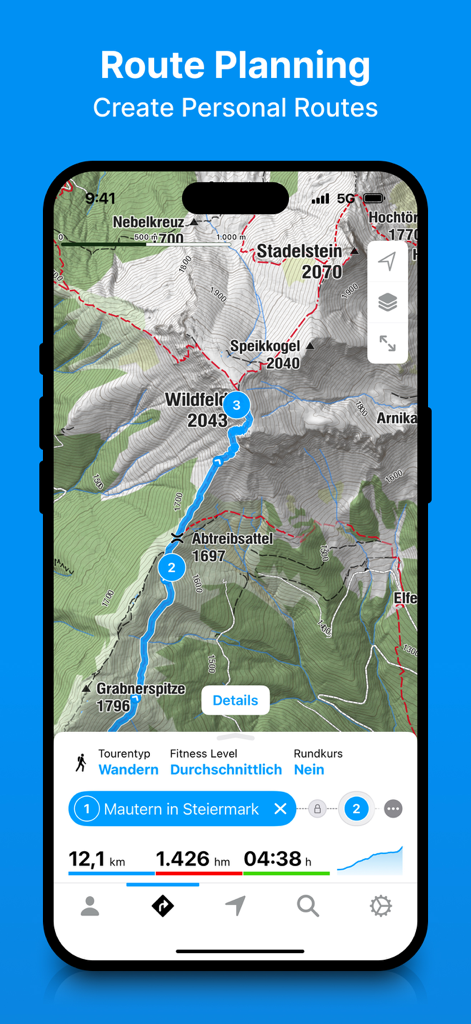
Bergfex app interface showing route planning on a detailed topographic mountain map with hiking stats
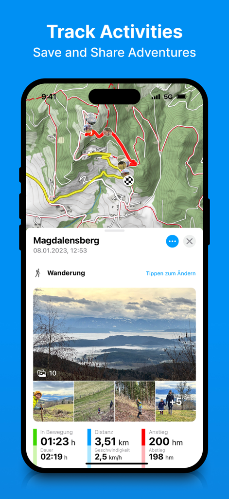
Bergfex app showing a tracked hiking route on a topographic map with integrated photos and performance statistics.
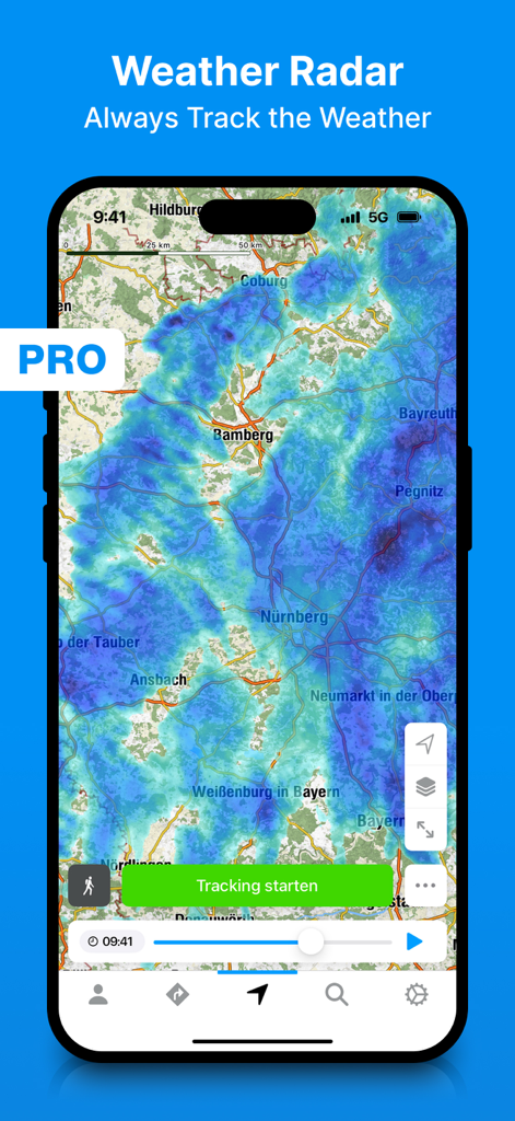
Bergfex hiking app weather radar interface with rain tracking overlay
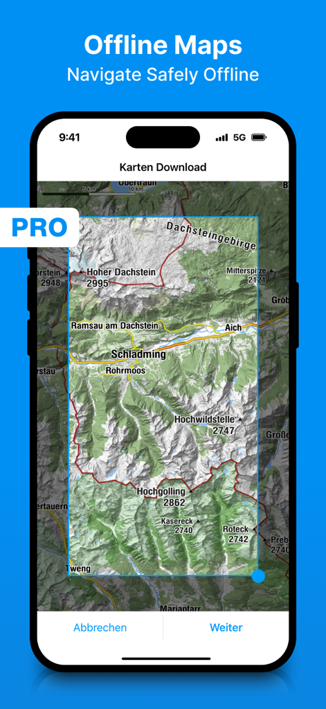
Selection screen for downloading offline topographic maps in the bergfex app
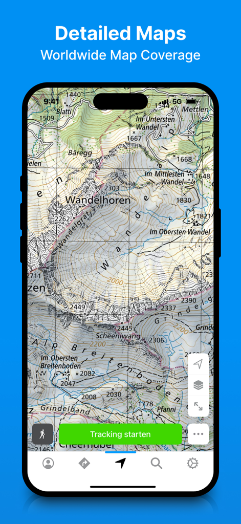
Detailed topographic map display in the bergfex hiking and tracking app
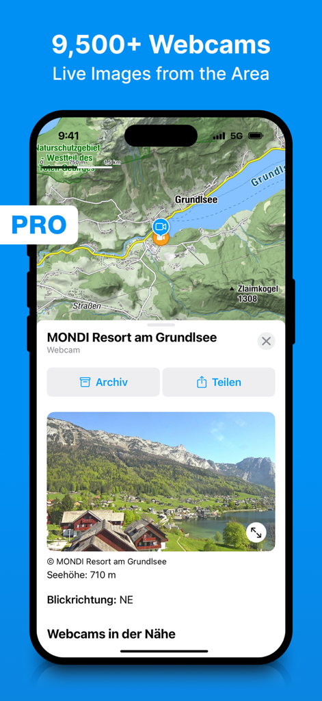
Screenshot of the bergfex hiking app showing live webcam images and a topographic map interface for outdoor trip planning.
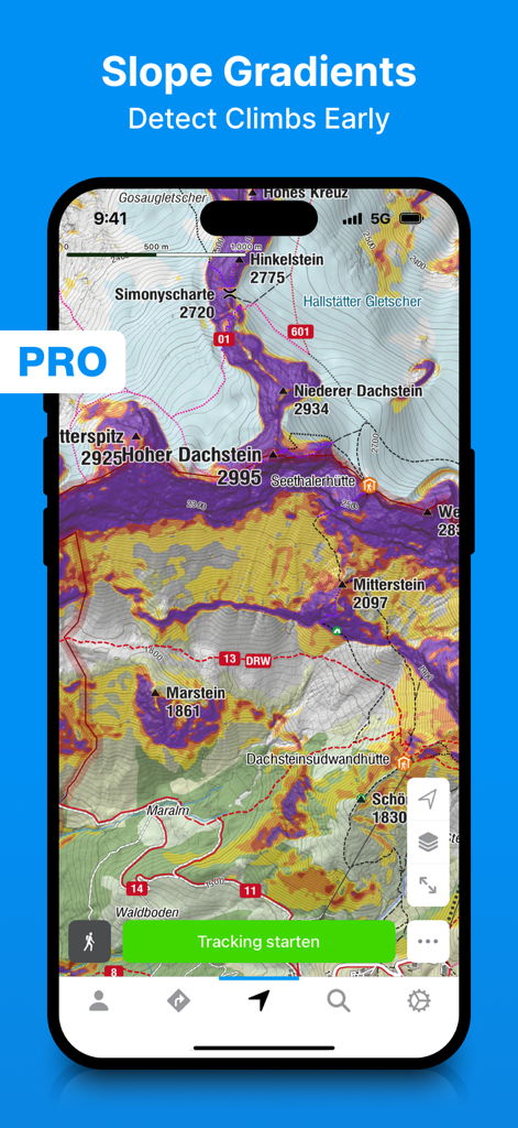
Bergfex app displaying slope gradient overlays on a topographic map for hikers and skiers
Description
Download
More Like This
Apps with similar features and user experience

AllTrails: Hike, Bike & Run
AllTrails, Inc.

Pedometer++
Cross Forward Consulting, LLC

Organic Maps: Offline Map
Organic Maps OU

Gaia GPS: Mobile Trail Maps
Trailbehind, INC.

Offline hiking maps: Mapy.com
Seznam.cz a.s.

Hiking Map Poland
Mapa Turystyczna sp. z o.o.

MapOut
Valnova GmbH

FarOut: Offline GPS Trail Maps
Atlas Guides DE, Inc.

Norgeskart
Norgeskart AS
This page is not an official page of the app or its developer, but an independent editorial publication created for informational and commentary purposes. Unless expressly stated otherwise, neither the app nor its developer is affiliated with, endorsed by, sponsored by, authorized by, or otherwise officially connected with MWM, Apple, Google Play, the app publisher, or the app's developer, and nothing on this page implies that the app was developed using MWM's services. Any trademarks, logos, screenshots, and other content remain the property of their respective owners.