This page is not an official page of the app or its developer, but an independent editorial publication created for informational and commentary purposes. Unless expressly stated otherwise, neither the app nor its developer is affiliated with, endorsed by, sponsored by, authorized by, or otherwise officially connected with MWM, Apple, Google Play, the app publisher, or the app's developer, and nothing on this page implies that the app was developed using MWM's services. Any trademarks, logos, screenshots, and other content remain the property of their respective owners.

Gaia GPS: Mobile Trail Maps
No signal? No problem. The app transforms your device into an untethered navigation powerhouse, making the wilderness yours.
Downloads
2.5M+User Rating
Total Ratings
37.9KPublisher
Category
NavigationLocales
17Latest Version
2026.2Size
120.1 MBFirst Released
May 22, 2017An evaluation of core functionalities for outdoor and wilderness enthusiasts.
Key Features Analysis: Gaia GPS
Robust Offline Mapping & GPS Navigation
The app provides essential offline map downloads and GPS navigation capabilities, enabling users to reliably track their position and follow routes even in remote areas without cellular service. This ensures safety and continuous exploration during wilderness adventures.
Comprehensive Topographical Map Layers
This tool features an extensive library of topographical maps and customizable layers, including Gaia Topo and detailed hill-shading. It allows users to thoroughly understand terrain, plan routes effectively, and visualize geographical features crucial for navigating varied landscapes.
Advanced Route Planning & Activity Tracking
It allows users to meticulously plan custom routes, discover established trails, and record their journeys with precise data such as distance, altitude, and elevation changes. Features like 'breadcrumbs' facilitate retracing steps, enhancing safety and navigational confidence.
Multi-Activity Integration & Specialized Data
The app integrates support for diverse outdoor activities, including hiking, backpacking, off-roading, overlanding, and skiing. It provides specific data and functionalities, such as recording 4x4 tracks or identifying ski resort information, tailored to enhance each distinct adventure.
Real-time Weather & Environmental Insights
The app delivers vital weather condition updates and environmental data, enabling users to proactively assess risks and adapt their plans. This includes information crucial for safety and preparedness, especially when venturing into unpredictable outdoor environments.
Premium Access to Specialized Maps
Through its premium offerings, the app grants access to highly specialized map sets, including NatGeo Trails Illustrated and Private Lands. This provides critical, detailed information essential for advanced planning, land use awareness, and navigating complex or restricted areas.
Frequently Asked Questions
Everything you need to know about Gaia GPS: Mobile Trail Maps
What is Gaia GPS?
Gaia GPS is a mobile application providing a comprehensive collection of hiking trails and camping sites. It offers GPS navigation, topographic maps, weather updates, and route planning for various outdoor activities like backpacking, off-roading, and skiing.
Does Gaia GPS offer offline map capabilities?
Yes, Gaia GPS offers offline maps. Users can download maps for offline use to navigate without cell service. The premium version allows downloading over 300 maps anytime.
Can users create and record their own routes with Gaia GPS?
Yes, users can create routes using snap-to-trail mode and custom waypoints with Gaia GPS. The app also records tracks, providing detailed statistics on speed, distance, elevation, and duration.
What types of outdoor activities does Gaia GPS support?
Gaia GPS supports diverse outdoor activities including hiking, backpacking, camping, RV travel, 4x4 off-roading, overlanding, skiing, and snowboarding. It provides specialized maps and features for each.
Does Gaia GPS integrate with Apple CarPlay?
Yes, Gaia GPS displays maps, routes, and waypoints directly on Apple CarPlay. This feature enhances navigation for offroad trails and other adventures.
What premium features are included with Gaia GPS Premium with Outside+?
Gaia GPS Premium with Outside+ includes access to over 300 maps, offline map downloads, weather and safety features, the Trailforks GPS biking app, expert-led courses, premium films, and unlimited digital access to Outside Network brands.
How can users manage their Gaia GPS subscription?
Users manage their Gaia GPS subscription by turning off auto-renewal through their Apple App Store account settings. Subscriptions automatically renew unless disabled at least 24 hours before the current period ends.
Does Gaia GPS provide cell coverage maps?
Yes, Gaia GPS offers cell coverage maps as premium layers for various carriers. These maps help users identify areas with or without cell service.
Can Gaia GPS show air quality or weather forecasts?
Yes, Gaia GPS displays air quality and weather forecasts. Map overlays include Air Quality (Current), Smoke Forecast (Today), Snow Forecast (24-Hour), and Precip Forecast (48-Hour).
What map layers are available in Gaia GPS?
Gaia GPS offers various map layers and packs including Gaia Topo, Overlanding, Satellite, Fresh Sat, NatGeo Trails, Public Land (US), Slope Angle, Avalanche Forecast, and Cell Coverage maps.
The following screenshots and description are sourced directly from the app's official store listing and are the property of the app developer.
App Store
Screenshots

The app welcomes users to adventure, showcasing an inspiring mountainous vista and prominent Gaia GPS branding as symbols of reliable outdoor exploration.
Confident Navigation

Users can explore remote areas confidently, viewing detailed topographic maps with a highlighted route and real-time activity metrics like speed and distance.
Offline Reliability

This tool helps users discover new adventures, featuring a map displaying elevation data and integrated articles from "Outside" for activity inspiration.
Discover Inspiration

The app simplifies adventure planning, providing an intuitive route creation interface with snap-to-trail functionality and a detailed elevation profile of the planned path.
Route Planning
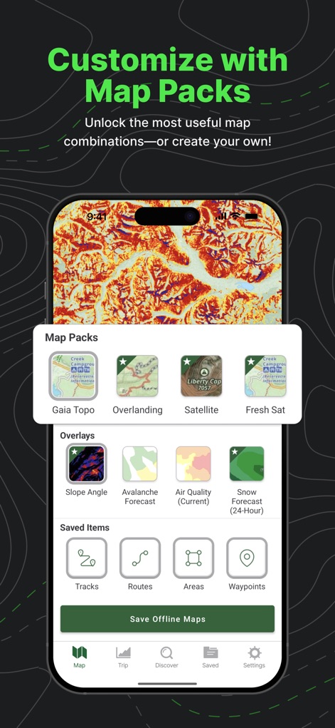
Users can personalize their mapping experience, choosing from a comprehensive selection of map packs like 'Gaia Topo' and adding practical overlays such as 'Slope Angle' and 'Avalanche Forecast'.
Map Customization

This tool offers a variety of specialized map layers, allowing users to select options like 'Natgeo Trails' and 'Public Land (US)' to suit any adventure.
Versatile Map Layers

The app provides in-depth performance tracking, showing comprehensive activity stats including a detailed speed profile and an informative elevation profile of recorded trips.
Performance Tracking

Users can assess network availability in the wilderness, viewing visual representations of cell coverage areas and selecting from a list of major network providers.
Cell Coverage
Description
Download
More Like This
Apps with similar features and user experience

AllTrails: Hike, Bike & Run
AllTrails, Inc.

Pedometer++
Cross Forward Consulting, LLC

Organic Maps: Offline Map
Organic Maps OU

Offline hiking maps: Mapy.com
Seznam.cz a.s.

Hiking Map Poland
Mapa Turystyczna sp. z o.o.

MapOut
Valnova GmbH

FarOut: Offline GPS Trail Maps
Atlas Guides DE, Inc.

Norgeskart
Norgeskart AS

GPX viewer - map
Lucas den Otter
This page is not an official page of the app or its developer, but an independent editorial publication created for informational and commentary purposes. Unless expressly stated otherwise, neither the app nor its developer is affiliated with, endorsed by, sponsored by, authorized by, or otherwise officially connected with MWM, Apple, Google Play, the app publisher, or the app's developer, and nothing on this page implies that the app was developed using MWM's services. Any trademarks, logos, screenshots, and other content remain the property of their respective owners.