This page is not an official page of the app or its developer, but an independent editorial publication created for informational and commentary purposes. Unless expressly stated otherwise, neither the app nor its developer is affiliated with, endorsed by, sponsored by, authorized by, or otherwise officially connected with MWM, Apple, Google Play, the app publisher, or the app's developer, and nothing on this page implies that the app was developed using MWM's services. Any trademarks, logos, screenshots, and other content remain the property of their respective owners.

Geo Field Area - GPS Measure
The essential tool for farmers, real estate agents, and landowners to measure acreage, mark boundaries, and share accurate results instantly—no professional equipment required.
Downloads
194K+User Rating
Total Ratings
3K+Publisher
Category
UtilitiesLocales
1Latest Version
1.4Size
73.2 MBFirst Released
Dec 6, 2023Master Your Land with Precision
From farm fields to property lines, Geo Field Area provides the professional tools you need to measure, map, and manage your land with absolute confidence.
Effortless Boundary Mapping
Define any plot size using simple map swipes or GPS tracking for instant, accurate acreage and perimeter results.
Professional-Grade Accuracy
Eliminate the guesswork with precise cartographic data tailored for the needs of farmers, ranchers, and real estate experts.
Frequently Asked Questions
Everything you need to know about Geo Field Area - GPS Measure
What is the Geo Field Area - GPS Measure app?
Geo Field Area - GPS Measure is an app for conveniently measuring land areas and distances on a map. It utilizes built-in GPS and cartographic data to calculate the area of any plot.
How does Geo Field Area - GPS Measure calculate land area?
The Geo Field Area - GPS Measure app calculates land area by allowing users to mark plot boundaries on a map with swipes. It automatically determines the area using GPS and cartographic data, and can display results on satellite maps.
Can I save my measurements in Geo Field Area - GPS Measure?
Yes, Geo Field Area - GPS Measure allows users to save their measurements. The "Saved measures" section displays previously recorded plot coordinates for easy access and re-evaluation.
Who is Geo Field Area - GPS Measure designed for?
Geo Field Area - GPS Measure is an indispensable tool for gardeners, farmers, and real estate agents. It is designed for anyone needing precise land area and distance measurements for various land plots.
Does Geo Field Area - GPS Measure support satellite maps?
Yes, Geo Field Area - GPS Measure supports satellite maps for calculations. Users can utilize a satellite view to accurately mark boundaries and perform land area and distance measurements.
How do I measure land with Geo Field Area - GPS Measure?
To measure land with Geo Field Area - GPS Measure, users simply mark the boundaries of the plot on the map using swipes. The app then automatically calculates the area based on the defined points.
Does Geo Field Area - GPS Measure measure distances?
Yes, Geo Field Area - GPS Measure measures both area and distance. The app displays calculated distances, such as 1.75 km as shown in map views, alongside area measurements.
Where can I find the privacy policy for Geo Field Area - GPS Measure?
The privacy policy for Geo Field Area - GPS Measure is available at https://stomberg-sro.com/terms-of-use-geofieldarea.pdf. This document outlines how the app handles user data.
Can I share measurements from Geo Field Area - GPS Measure?
Yes, you can share measurements from Geo Field Area - GPS Measure. The app allows users to share their saved measurements with others through various social media platforms.
The following screenshots and description are sourced directly from the app's official store listing and are the property of the app developer.
App Store
Screenshots
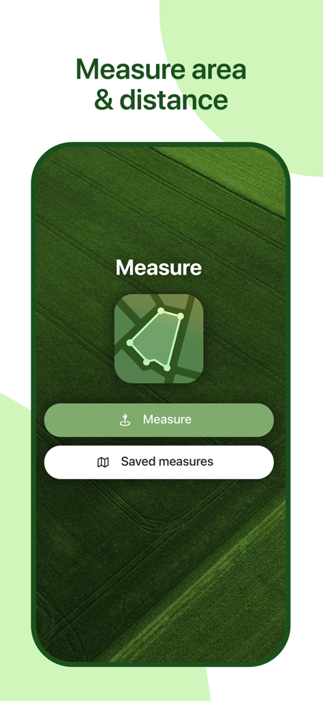
Home screen of the Geo Field Area app showing measure and saved measures buttons over a green field background
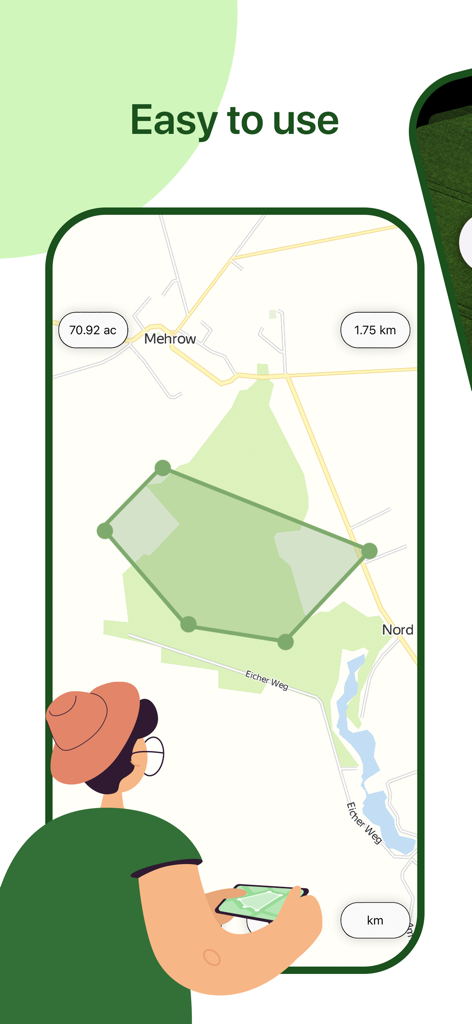
Smartphone screen showing easy land area measurement on a map with GPS.
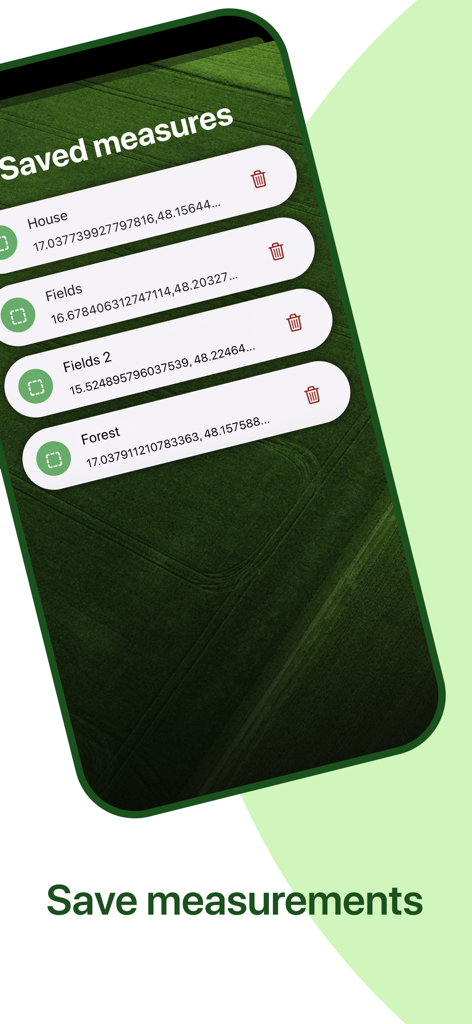
List of saved land measurements for houses fields and forests in the app
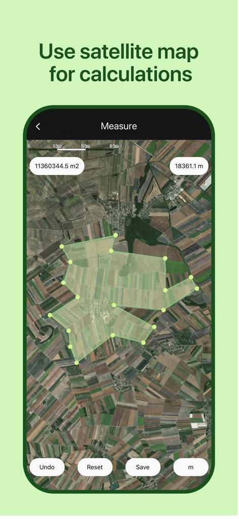
Geo Field Area app interface displaying land measurement on a satellite map
Description
Download
More Like This
Apps with similar features and user experience

Field MapS - Measure Land GPS
Aleksei Metelkin

Field Area MeasureーLand Parcel
Irina Metelkina

FieldCalc - GPS Area Measure
Pravin Gondaliya

GPS Fields Area Measure Map
Rento UAB

GLand: GPS Field Area Measure
Authai Yaprasat

Distance - Find My Distance
Mapnitude Company Limited

Area & Distance - Map Measure
Mapnitude Company Limited

Measure Map
Xuan Luong Do

Field Area Measure
Yaroslav Babenko
This page is not an official page of the app or its developer, but an independent editorial publication created for informational and commentary purposes. Unless expressly stated otherwise, neither the app nor its developer is affiliated with, endorsed by, sponsored by, authorized by, or otherwise officially connected with MWM, Apple, Google Play, the app publisher, or the app's developer, and nothing on this page implies that the app was developed using MWM's services. Any trademarks, logos, screenshots, and other content remain the property of their respective owners.