This page is not an official page of the app or its developer, but an independent editorial publication created for informational and commentary purposes. Unless expressly stated otherwise, neither the app nor its developer is affiliated with, endorsed by, sponsored by, authorized by, or otherwise officially connected with MWM, Apple, Google Play, the app publisher, or the app's developer, and nothing on this page implies that the app was developed using MWM's services. Any trademarks, logos, screenshots, and other content remain the property of their respective owners.

GPS Maps Camera
Transform your photos into precise data logs. It provides an undeniable record, making every shot count.
Downloads
750k+User Rating
Total Ratings
92Publisher
Category
NavigationLocales
21Latest Version
2.0Size
35.2 MBFirst Released
Jul 17, 2024An analytical overview of key features enhancing location-aware photography for travelers, outdoor enthusiasts, and professionals.
Evaluation of GPS Maps Camera: Core Functionalities
Flexible Geocoordinate & Address Formats
This tool supports multiple GPS coordinate formats (Decimal, MGRS, UTM) and adjustable address displays, catering to diverse professional and technical mapping requirements.
Extensive Environmental Data Overlay
The app integrates a wealth of environmental data, including weather conditions, wind speed, compass direction, magnetic field, atmospheric pressure, and altitude, providing a comprehensive contextual overlay for photos.
Advanced Map Data Integration
The app allows users to seamlessly embed map data into photos, with options for both automatic and manual location input, ensuring precise geotagging for various needs.
Multiple Map View Options
The app offers diverse map views including Normal, Satellite, and Hybrid, allowing users to choose the most suitable geographical context for their embedded data.
Comprehensive Date, Time & Time Zone Stamping
It allows for precise date and time stamping in various formats, alongside customizable time zone selection, crucial for chronological accuracy of geotagged images.
Dynamic Feature Visibility Control
It provides the flexibility to selectively hide or display any embedded data feature, allowing users to tailor the information presented on their photographs to specific needs.
Customizable Stamp Templates
It provides a wide array of templates and format arrangements, enabling users to customize the visual presentation of embedded data on their photos.
Integrated Photo Capture & Management
The app offers direct photo capture with embedded stamps, alongside essential management functions like saving, sharing, and deleting images within the application.
Frequently Asked Questions
Everything you need to know about GPS Maps Camera
What is the GPS Maps Camera app?
The GPS Maps Camera app captures and customizes photos with detailed map data, weather conditions, and various informational stamps. It is designed for photographers, travelers, and outdoor enthusiasts.
Can I manually add GPS coordinates to photos using GPS Maps Camera?
Yes, the GPS Maps Camera app allows users to manually set GPS coordinates and location data for their photos. This feature is available in the Map Data section of the app.
What customization options does the GPS Maps Camera app offer for templates?
The GPS Maps Camera app offers various template customization options, including different map types, address formats, GPS coordinate formats (Decimal, MGRS, UTM), date/time formats, and weather information units.
Does GPS Maps Camera display weather information on photo stamps?
Yes, the GPS Maps Camera app displays weather information directly on photo stamps. Users can choose to show temperature in Fahrenheit or Celsius and wind speed in their preferred units.
How can I manage my photos within the GPS Maps Camera app?
After capturing images with a stamp, the GPS Maps Camera app allows users to easily delete, share, or save photos to their gallery. It also includes a QR code scanning feature.
What are the subscription terms for the GPS Maps Camera app?
The GPS Maps Camera app subscription automatically renews unless turned off 24 hours before the period ends. Payment is charged to the iTunes Account, and no cancellation is allowed during an active subscription.
Can I choose different map views in the GPS Maps Camera templates?
Yes, the GPS Maps Camera app allows users to switch between Normal, Satellite, and Hybrid map views within the advanced template options. This enhances the visual context of geotagged photos.
Does the GPS Maps Camera app automatically calculate altitude and accuracy?
Yes, the GPS Maps Camera app automatically calculates and displays altitude. It also provides accuracy details in two formats, ensuring precise geotagging information for your captured images.
The following screenshots and description are sourced directly from the app's official store listing and are the property of the app developer.
App Store
Screenshots
This tool allows users to embed precise location coordinates and environmental data like temperature and wind speed directly onto their photographs.
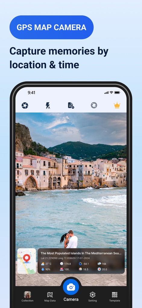
Geotagged Memories
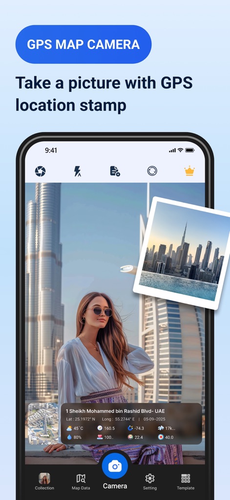
Users can instantly capture high-quality images and automatically apply a customizable GPS stamp displaying exact coordinates and detailed address information.
Instant Geo-Stamping
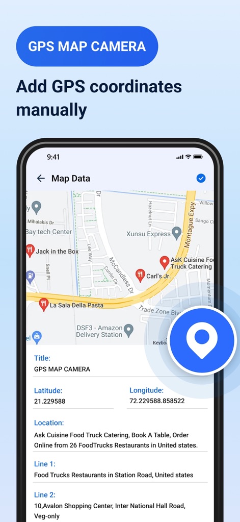
This feature provides granular control, enabling users to manually input precise latitude and longitude coordinates or custom address details for any desired location.
Manual Geo-Input
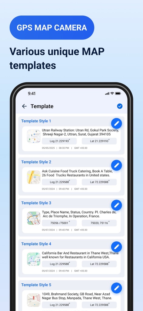
The app offers a wide array of customizable templates, allowing users to select distinct map views and arrange date and time formats to match their specific needs.
Diverse Stamp Templates
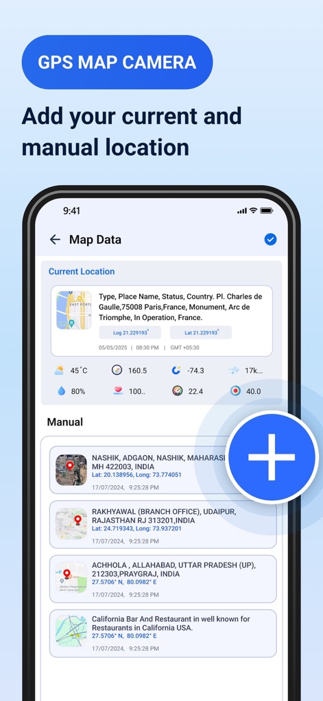
This feature empowers users to either utilize their current GPS location data or efficiently manage and add multiple custom manual locations for geotagging purposes.
Flexible Location Management
Description
Download
More Like This
Apps with similar features and user experience

Timestamp Camera -AI Timestamp
Shanghai Zongchong Information Technology Co., Ltd

Timestamp Camera - Date Stamp
Artify Inc.

Timestamp Camera: Time & GPS
Practical Apps from Sweden AB

Timestamp camera - gps cam
Guangzhou Siyue Network Technology Co., Ltd.

DateStamper
Jordan Hipwell

Timestamp Camera Basic
玉彬 陈

GPS Map Camera : Geo Photos
Chirag Gabani

Timestamp Camera: Time stamp
燕倩 费

Timestamp Camera - Time & GPS
Shaanxi Ruidebao Technology Co.,Ltd
This page is not an official page of the app or its developer, but an independent editorial publication created for informational and commentary purposes. Unless expressly stated otherwise, neither the app nor its developer is affiliated with, endorsed by, sponsored by, authorized by, or otherwise officially connected with MWM, Apple, Google Play, the app publisher, or the app's developer, and nothing on this page implies that the app was developed using MWM's services. Any trademarks, logos, screenshots, and other content remain the property of their respective owners.