This page is not an official page of the app or its developer, but an independent editorial publication created for informational and commentary purposes. Unless expressly stated otherwise, neither the app nor its developer is affiliated with, endorsed by, sponsored by, authorized by, or otherwise officially connected with MWM, Apple, Google Play, the app publisher, or the app's developer, and nothing on this page implies that the app was developed using MWM's services. Any trademarks, logos, screenshots, and other content remain the property of their respective owners.

Navitel Navigator
Navigate 66 countries with total offline independence. From specialized cargo routing for heavy vehicles to premium Head-Up Display tech, get professional-grade precision wherever the road leads—no signal required.
Downloads
1M+User Rating
Total Ratings
3K+Publisher
Category
NavigationLocales
36Latest Version
12.6.1433Size
93.8 MBFirst Released
Mar 5, 2013Precision Navigation for the Driven Professional
Whether you're hauling cargo across state lines or exploring international cities, Navitel Navigator provides the offline reliability and specialized routing that standard apps can't match.
Zero-Data Reliability
Navigate 66 countries with high-detail offline maps. Stay on track in rural dead zones and avoid international roaming fees with 100% autonomous GPS.
Specialized Cargo Logic
Built for heavy-duty vehicles from 3.5 to 40+ tons. Plan routes that automatically respect weight limits, bridge heights, and commercial road restrictions.
Frequently Asked Questions
Everything you need to know about Navitel Navigator
Does Navitel Navigator support offline maps?
Yes, Navitel Navigator supports offline maps. Users can download maps for 66 countries and use them without an internet connection, saving roaming costs and ensuring navigation in areas with poor communication.
Does Navitel Navigator support Apple CarPlay?
Yes, Navitel Navigator supports Apple CarPlay. Users can display and use the navigation on their car's head unit for a seamless in-car experience.
Does Navitel Navigator provide real-time traffic information?
Yes, Navitel Navigator provides real-time traffic information via Navitel.Traffic. It displays traffic jams, accidents, road works, and other incidents to help optimize routes.
Does Navitel Navigator offer navigation for trucks?
Yes, Navitel Navigator features a Cargo graph for trucks. It builds routes considering road signs and specific restrictions for vehicles from 3.5 to 40+ tons, including custom truck parameters.
Does Navitel Navigator warn about speed cameras and radars?
Yes, Navitel Navigator provides SpeedCam warnings. It informs users about radars, speed cameras, and road restrictions to enhance driving safety and awareness.
How many alternative routes does Navitel Navigator suggest?
Navitel Navigator suggests three alternative routes. Each route includes detailed information on distance and estimated travel time, allowing users to choose the most suitable option.
Does Navitel Navigator display maps in 3D?
Yes, Navitel Navigator displays maps in 3D. It includes 3D Maps with textures and building heights, and also shows multi-level road interchanges in 3D mode.
How can I contact support for Navitel Navigator?
Users can contact Navitel Navigator support by emailing support@navitel.cz. The support team assists with any questions or issues regarding the application.
The following screenshots and description are sourced directly from the app's official store listing and are the property of the app developer.
App Store
Screenshots
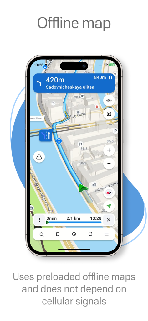
Navitel Navigator app displaying offline 3D navigation and route guidance on a smartphone.
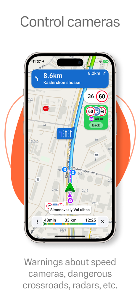
Navitel Navigator app interface showing navigation map with speed camera and radar warnings
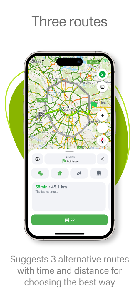
Navitel Navigator app displaying three alternative routes with time and distance details
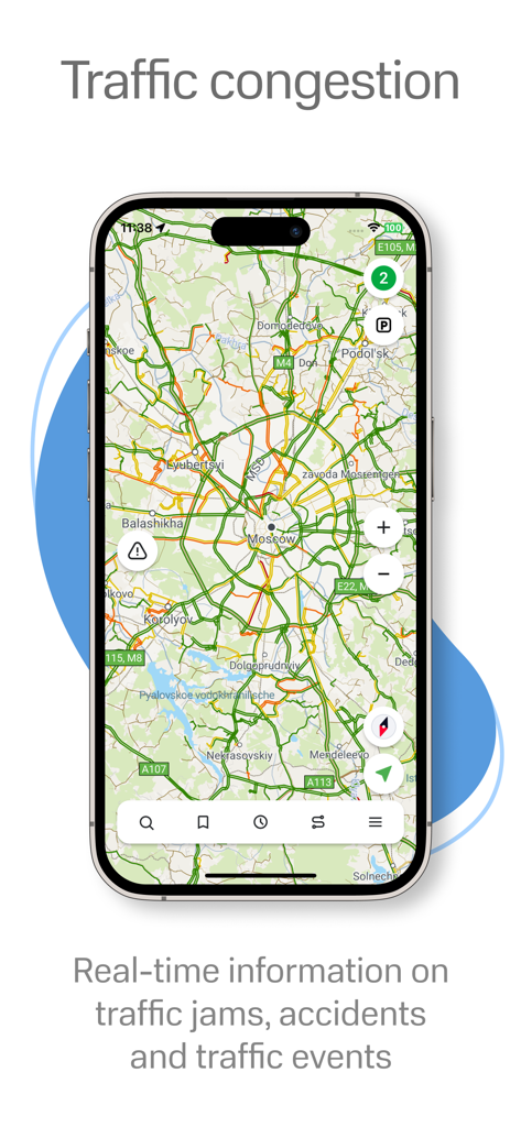
Real-time traffic congestion and incident alerts on Navitel Navigator map
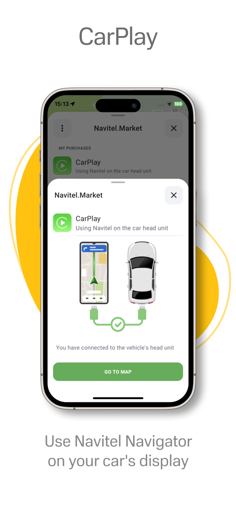
Navitel Navigator app interface showing CarPlay integration for vehicle dashboard navigation
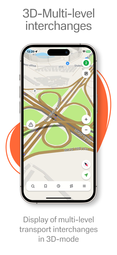
Navitel Navigator app displaying a detailed multi level road interchange in 3D mode on an iPhone
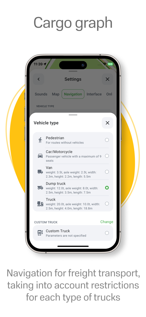
Navitel Navigator app displaying cargo graph vehicle type selection for professional truck navigation
Description
Download
More Like This
Apps with similar features and user experience

MAPS.ME: Offline Maps, GPS Nav
Convexity Holdings AG

CoMaps
Anton Wenemoser

GPS Navigation & Path Finder
Muhammad Asad Khan

MapFactor Navigator - GPS Maps
MAPFACTOR, s.r.o.

Guru Maps Pro & GPS Tracker
Evgen Bodunov

Offline Map Navigation
virtualmaze

Karta GPS - Offline Maps Nav
Karta Software Technologies lda

Genius Maps: GPS Navigation
Mireo d.d.

NaviMaps: 3D GPS Navigation
CE Info Systems Limited
This page is not an official page of the app or its developer, but an independent editorial publication created for informational and commentary purposes. Unless expressly stated otherwise, neither the app nor its developer is affiliated with, endorsed by, sponsored by, authorized by, or otherwise officially connected with MWM, Apple, Google Play, the app publisher, or the app's developer, and nothing on this page implies that the app was developed using MWM's services. Any trademarks, logos, screenshots, and other content remain the property of their respective owners.