This page is not an official page of the app or its developer, but an independent editorial publication created for informational and commentary purposes. Unless expressly stated otherwise, neither the app nor its developer is affiliated with, endorsed by, sponsored by, authorized by, or otherwise officially connected with MWM, Apple, Google Play, the app publisher, or the app's developer, and nothing on this page implies that the app was developed using MWM's services. Any trademarks, logos, screenshots, and other content remain the property of their respective owners.

onX Backcountry: Trail GPS App
This app doesn't just map trails; it deciphers the wild, turning uncertainty into calculated moves.
Downloads
1M+User Rating
Total Ratings
5.7KPublisher
Category
NavigationLocales
1Latest Version
26.13.0Size
433.2 MBFirst Released
Dec 9, 2020An in-depth evaluation highlighting critical functionalities for outdoor enthusiasts navigating remote and challenging terrains.
Analytical Overview: Key Features of onX Backcountry: Trail GPS App
Offline Map Capabilities
The app provides comprehensive offline 3D maps, allowing users to navigate and visualize terrain even without cell service, which is essential for remote backcountry excursions.
Advanced Topographical Mapping
This tool features advanced topographical maps, including LiDAR, 3D visualizations, and Avalanche Terrain Exposure Scale (ATES) data, offering unparalleled detail for terrain assessment and safety.
Hazard Awareness Map Layers
The app provides toggleable map layers that display critical safety information such as active wildfires, avalanche terrain, and private land boundaries, enhancing user safety and compliance.
GPS Tracking & Trip Statistics
It allows users to track their live position via GPS, record a breadcrumb trail, and measure key trip statistics like distance, elevation gain, and speed for review and analysis.
Extensive Route & POI Database
This tool offers an extensive database of over 650,000 miles of trails, 300,000 rock climbs, 4,000 ski routes, and 550,000 recreation icons, facilitating discovery and planning.
Custom Route Planning & Waypoints
It allows users to map out custom routes with a snap-to-trail feature and add personalized waypoints to points of interest, offering flexibility in trip planning.
Real-time Environmental Data
The app provides localized weather forecasts, hour-by-hour wind predictions, and recent satellite imagery, enabling users to make informed decisions based on current conditions.
Activity-Specific Planning & Map Modes
The app provides activity-specific map modes for hiking, mountain biking, and backcountry skiing, offering tailored data and tools relevant to each pursuit.
Frequently Asked Questions
Everything you need to know about onX Backcountry: Trail GPS App
What is onX Backcountry used for?
onX Backcountry is a GPS map app for outdoor recreation, enabling users to discover and navigate new trails for hiking, skiing, mountain biking, and climbing, even offline.
Does onX Backcountry offer offline navigation?
Yes, onX Backcountry allows users to download 3D maps with interactive trail data for offline use. This turns a phone into a handheld GPS device without cell service.
Can I create custom routes in onX Backcountry?
Yes, onX Backcountry allows users to map custom routes seamlessly with its snap-to-trail feature. Users can also set Waypoints and review detailed slope data for planning.
What types of maps does onX Backcountry provide?
onX Backcountry provides 3D maps, HD topographic maps, satellite imagery, and hybrid views. Users can also select map modes specific to hiking, MTB, climbing, or ski touring.
What safety features are included in onX Backcountry?
onX Backcountry includes safety tools like localized weather forecasts, hourly wind data, and Trail Reports. It also features map layers to monitor wildfire, air quality, and avalanche terrain exposure.
Is there a free trial for onX Backcountry?
Yes, onX Backcountry offers a free seven-day Premium trial upon app installation. This trial provides access to all the app's advanced features for a complete backcountry experience.
What are the exclusive features for onX Backcountry Elite members?
onX Backcountry Elite membership exclusively includes the Private Land Layer, which shows property maps and boundaries, and Recent Imagery, providing detailed satellite views from the past two weeks.
Can onX Backcountry track my outdoor activity statistics?
Yes, onX Backcountry allows users to track their location and measure activity stats. It displays key trip details such as distance, elevation gain, and elevation loss in seconds.
Where can I find the privacy policy for onX Backcountry?
The official privacy policy for onX Backcountry is available on the onXmaps website. You can find the detailed policy at https://www.onxmaps.com/privacy-policy.
Does onX Backcountry provide detailed trail information?
Yes, onX Backcountry offers a "Guidebook Experience" with detailed trail descriptions. This includes trail lengths, difficulty levels, elevation profiles, and user reviews for various routes.
The following screenshots and description are sourced directly from the app's official store listing and are the property of the app developer.
App Store
Screenshots
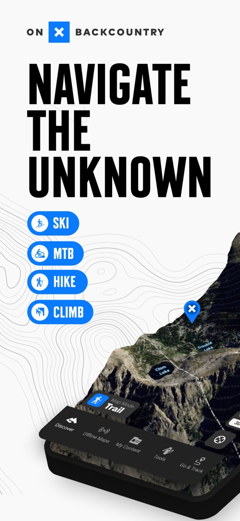
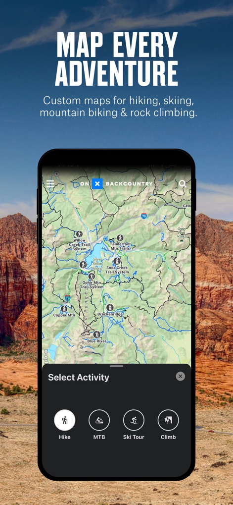
Users can seamlessly switch between activity-specific map modes like 'Hike' and 'Ski' directly from the main map view.
Activity Map Modes
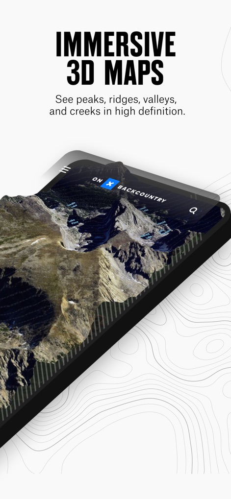
The app renders stunning 3D maps, allowing users to visualize terrain features like peaks and valleys with exceptional clarity.
Detailed 3D Topography
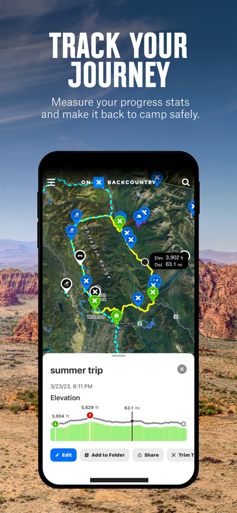
This tool records detailed trip statistics, displaying GPS-tracked routes and an elevation profile graph for comprehensive journey review.
Route Tracking & Stats
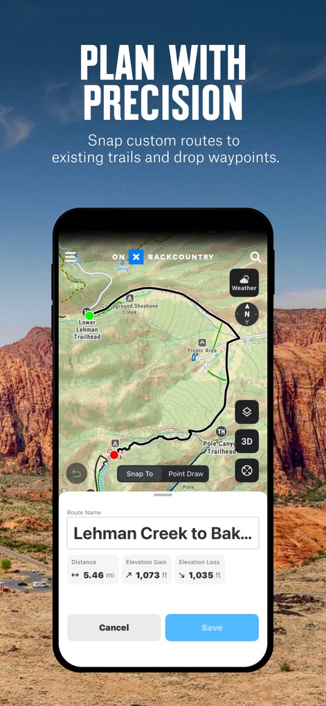
Users can precisely plan custom routes utilizing the 'Snap To' trail feature and immediately view essential metrics like distance and elevation gain.
Custom Route Planning
The app offers comprehensive maps with activity-specific layers, allowing users to select modes such as 'Hike' or 'MTB' to tailor their view.
Multi-Activity Maps
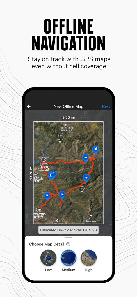
This tool enables users to download specific map areas for offline use, with customizable detail levels from 'Low' to 'High'.
Offline Map Downloads
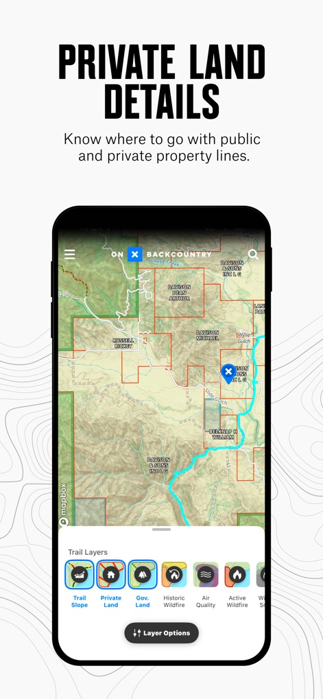
The app provides critical land ownership data, displaying distinct boundaries for private land and government land to ensure responsible outdoor activity.
Land Ownership Layers
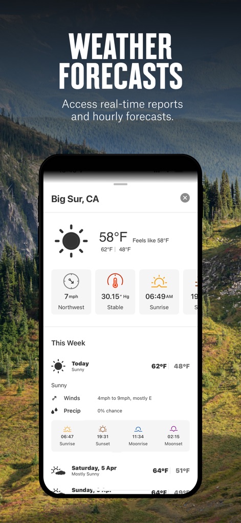
Users access comprehensive weather information directly within the app, including current temperature and hour-by-hour wind forecasts.
Integrated Weather Data
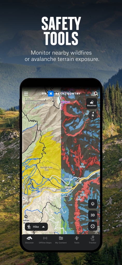
The app enhances safety with dedicated hazard layers, allowing users to visualize wildfire perimeters and avalanche terrain exposure simultaneously.
Hazard Awareness

Users can explore detailed route guides, complete with trail descriptions and key metrics like distance and elevation gain, similar to a traditional guidebook.
Expert Route Guides
Description
Download
More Like This
Apps with similar features and user experience

AllTrails: Hike, Bike & Run
AllTrails, Inc.

Pedometer++
Cross Forward Consulting, LLC

Organic Maps: Offline Map
Organic Maps OU

Gaia GPS: Mobile Trail Maps
Trailbehind, INC.

Offline hiking maps: Mapy.com
Seznam.cz a.s.

Hiking Map Poland
Mapa Turystyczna sp. z o.o.

MapOut
Valnova GmbH

FarOut: Offline GPS Trail Maps
Atlas Guides DE, Inc.

Norgeskart
Norgeskart AS
This page is not an official page of the app or its developer, but an independent editorial publication created for informational and commentary purposes. Unless expressly stated otherwise, neither the app nor its developer is affiliated with, endorsed by, sponsored by, authorized by, or otherwise officially connected with MWM, Apple, Google Play, the app publisher, or the app's developer, and nothing on this page implies that the app was developed using MWM's services. Any trademarks, logos, screenshots, and other content remain the property of their respective owners.