This page is not an official page of the app or its developer, but an independent editorial publication created for informational and commentary purposes. Unless expressly stated otherwise, neither the app nor its developer is affiliated with, endorsed by, sponsored by, authorized by, or otherwise officially connected with MWM, Apple, Google Play, the app publisher, or the app's developer, and nothing on this page implies that the app was developed using MWM's services. Any trademarks, logos, screenshots, and other content remain the property of their respective owners.

OS Maps: Walk, Hike, Run, Bike
Experience the ultimate precision in trail planning with 3D topographic maps, real-time safety alerts, and reliable offline GPS. Designed for the methodical explorer who hikes, bikes, and runs without limits.
Downloads
2M+User Rating
Total Ratings
90K+Publisher
Category
NavigationLocales
1Latest Version
5.5.5Size
202.8 MBFirst Released
Jun 10, 2015Precision Tools for the Methodical Explorer
Go beyond the basics with technical mapping, seamless multi-device planning, and advanced safety features designed for serious outdoor adventures.
Visualize Every Ridge in 3D
Understand the landscape before you arrive with stunning 3D map layers and detailed topographic data for superior situational awareness.
Laptop to Hilltop Syncing
Plan precision routes on your desktop with automatic 'snap-to-path' technology and sync them instantly to your iPhone and Apple Watch.
Frequently Asked Questions
Everything you need to know about OS Maps: Walk, Hike, Run, Bike
What is OS Maps?
OS Maps is an application designed to guide users through outdoor activities like hiking, biking, or running across the USA. It helps users discover and plan trails in national parks, local neighborhoods, and coastal areas.
What types of outdoor activities does OS Maps support?
OS Maps supports various outdoor activities, including hiking, biking, and running. It provides detailed maps and guidance for these activities across different terrains and locations.
Can users create their own routes in OS Maps?
Yes, OS Maps allows users to plot their own trails to follow, share, and record. The app also features automatic 'snap-to-path' functionality for easy route planning between waypoints.
Does OS Maps support offline map usage?
Yes, OS Maps supports offline map usage. Users can download their favorite areas to view maps and chosen routes without cell reception. It also allows exporting trails and routes to GPX devices.
What map layers are available in OS Maps?
OS Maps offers multiple map layers, including detailed topographic mapping, aerial view, and 3D map layers. These options allow users to explore the landscape in various levels of detail.
Does OS Maps offer live GPS tracking and safety features?
Yes, OS Maps provides live GPS location tracking and off-course alerts to help users stay on track. It also includes community alerts for real-time updates on trail conditions from other users.
Is OS Maps compatible with multiple devices?
Yes, OS Maps allows users to view, create, and sync routes and activities with a single account across multiple devices. It supports planning on desktop and recording on mobile and Apple Watch.
Can users print maps from OS Maps?
Yes, OS Maps offers an unlimited printing feature. Users can print copies of trails and maps to have a physical backup available during their outdoor activities.
How much does a subscription to OS Maps cost?
A monthly subscription for OS Maps costs $4.99. An annual subscription is available for $28.99, offering premium access to the app's features.
How can I manage or cancel my OS Maps subscription?
Users can manage their OS Maps subscription through the App Store App after purchase. Subscriptions can be canceled at any time by accessing the Subscriptions list within iOS settings.
Are OS Maps subscriptions auto-renewing?
Yes, OS Maps subscriptions are auto-renewing by default. They renew automatically unless the user unsubscribes at least 24 hours before the end of the current billing period.
Where can I find support for OS Maps?
Users can find support for OS Maps and report issues by visiting the contact page at https://www.ordnancesurvey.co.uk/contact-us. This link is provided for feedback and problem resolution.
The following screenshots and description are sourced directly from the app's official store listing and are the property of the app developer.
App Store
Screenshots

Two hikers with backpacks walking up a hill at sunset with text saying Adventure Outside and App Store Editors Choice badge
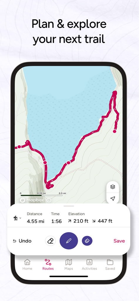
A smartphone displaying the OS Maps app interface with a planned coastal hiking route including distance time and elevation stats
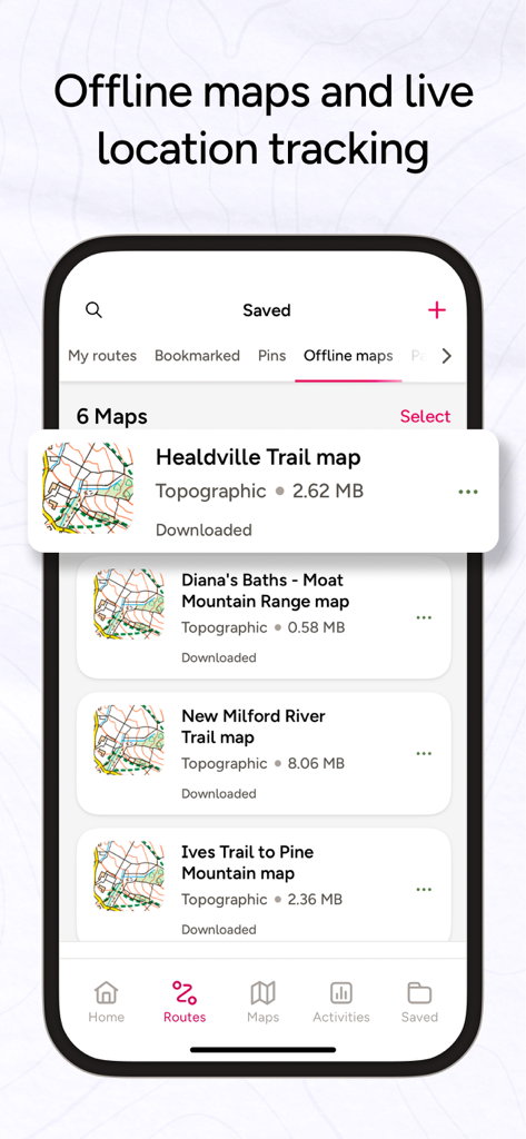
OS Maps mobile app interface showing a list of saved offline topographic trail maps for hiking and navigation
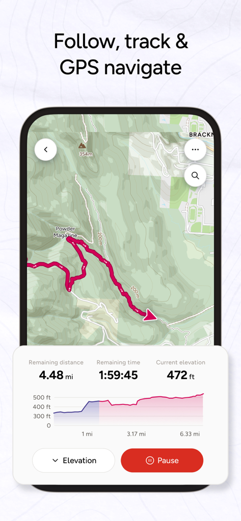
OS Maps app interface showing live GPS tracking and elevation profile for a hiking route.
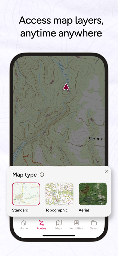
OS Maps app interface displaying a topographic map and a selection menu for standard, topographic, and aerial map layers.

Two hikers on a mountain trail with a five star review for OS Maps
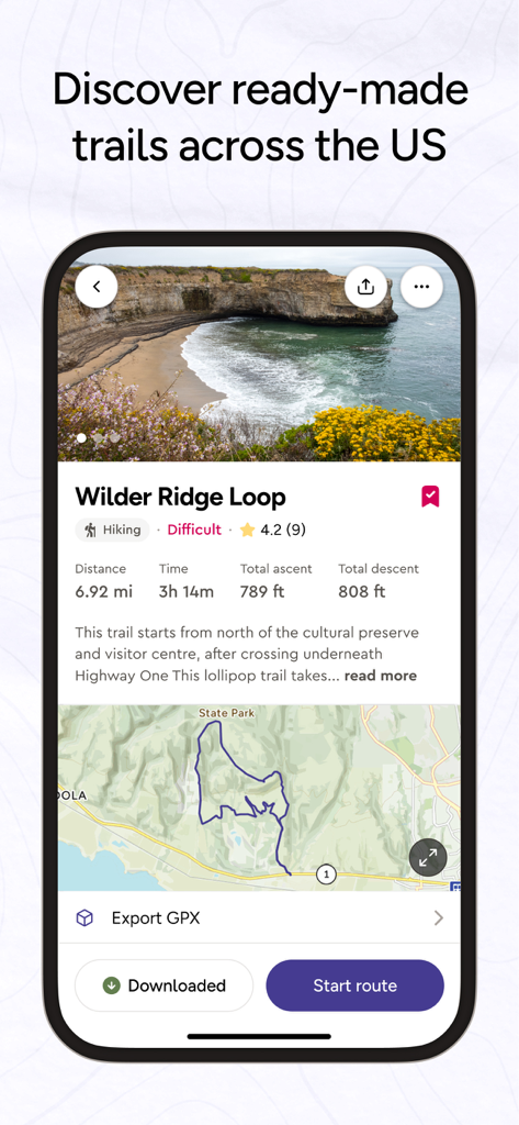
OS Maps mobile app interface showing hiking trail details including distance elevation and a route map
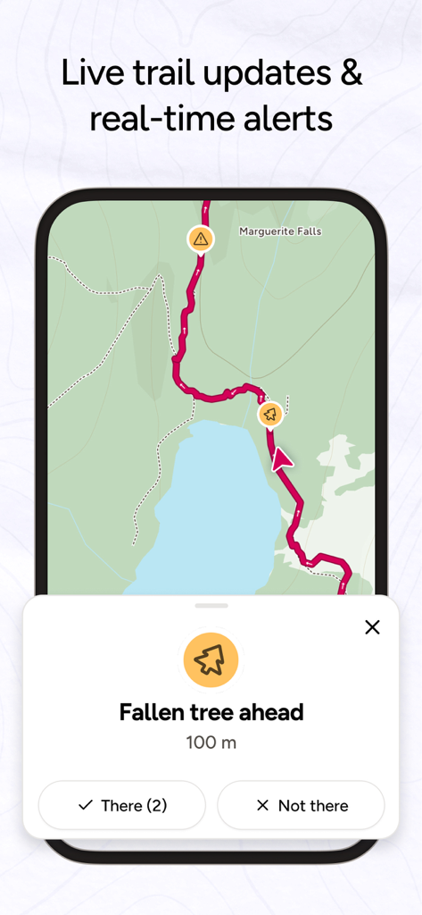
OS Maps interface displaying live community alerts for trail hazards like a fallen tree
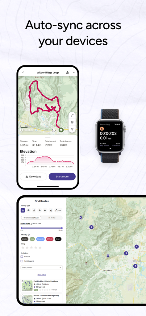
OS Maps app interface synchronized across iPhone Apple Watch and tablet showing route details and activity tracking.
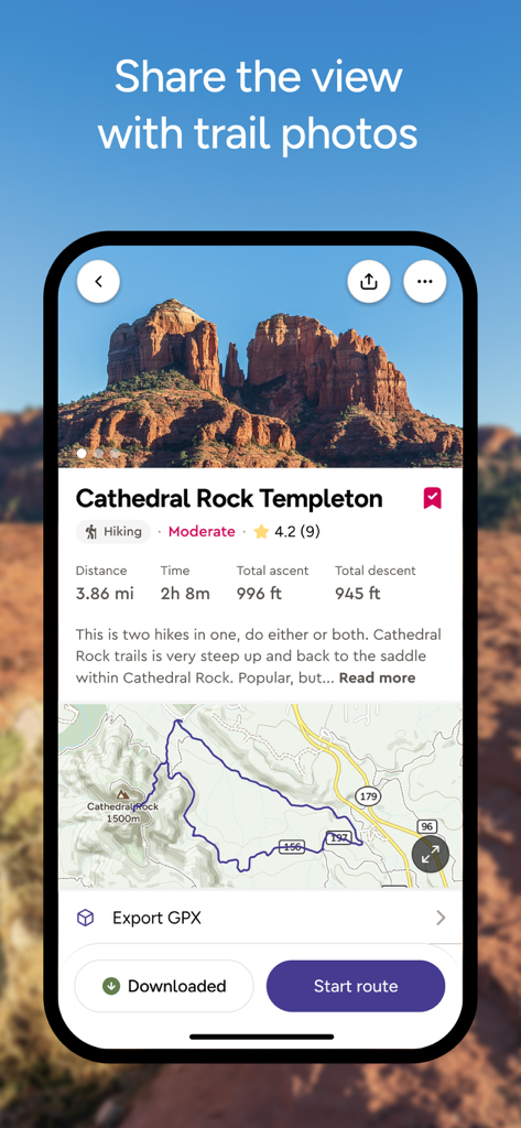
OS Maps mobile app displaying hiking route details for Cathedral Rock Templeton including map and elevation stats
Description
Download
More Like This
Apps with similar features and user experience

AllTrails: Hike, Bike & Run
AllTrails, Inc.

Pedometer++
Cross Forward Consulting, LLC

Organic Maps: Offline Map
Organic Maps OU

Gaia GPS: Mobile Trail Maps
Trailbehind, INC.

Offline hiking maps: Mapy.com
Seznam.cz a.s.

Hiking Map Poland
Mapa Turystyczna sp. z o.o.

MapOut
Valnova GmbH

FarOut: Offline GPS Trail Maps
Atlas Guides DE, Inc.

Norgeskart
Norgeskart AS
This page is not an official page of the app or its developer, but an independent editorial publication created for informational and commentary purposes. Unless expressly stated otherwise, neither the app nor its developer is affiliated with, endorsed by, sponsored by, authorized by, or otherwise officially connected with MWM, Apple, Google Play, the app publisher, or the app's developer, and nothing on this page implies that the app was developed using MWM's services. Any trademarks, logos, screenshots, and other content remain the property of their respective owners.