This page is not an official page of the app or its developer, but an independent editorial publication created for informational and commentary purposes. Unless expressly stated otherwise, neither the app nor its developer is affiliated with, endorsed by, sponsored by, authorized by, or otherwise officially connected with MWM, Apple, Google Play, the app publisher, or the app's developer, and nothing on this page implies that the app was developed using MWM's services. Any trademarks, logos, screenshots, and other content remain the property of their respective owners.

OsmAnd Maps Travel & Navigate
No signal? No problem. This app hands you the power to roam anywhere, untethered from unreliable connections.
Downloads
2.5M+User Rating
Total Ratings
39.1KPublisher
Category
TravelLocales
77Latest Version
5.2.3Size
245.6 MBFirst Released
Apr 21, 2015An analytical overview of key features for demanding navigation users.
Core Strengths of OsmAnd Maps
Offline Global Mapping & Navigation
The app provides comprehensive offline maps globally, ensuring reliable navigation and route plotting even without an internet connection, critical for remote travel and areas with poor signal.
Advanced Route Planning & GPX Management
It allows users to plan intricate routes with multiple waypoints, consider inclines and road exclusions, and record, display, and navigate custom GPX tracks, vital for outdoor exploration and professional trips.
Customizable Navigation Profiles
This tool features adaptable navigation profiles for various modes of transport, including cars, bicycles, 4x4, and pedestrians, optimizing routes based on specific vehicle dimensions and preferences.
Specialized Map Styles & Topographic Overlays
The app offers a variety of map styles tailored for different activities (e.g., touring, topographic, off-road) and supports shading relief and contour lines, providing highly detailed geographical insights.
Data Privacy & Open Source Philosophy
This tool is open-source and does not collect user data, ensuring complete privacy and giving users full control over their information, a significant advantage for privacy-conscious individuals.
Unlimited Offline Map Downloads
It provides access to unlimited map downloads, empowering users to store extensive regional or global maps offline, which is indispensable for extensive travel without internet access.
Dynamic POI Search & Display
The app allows users to search for points of interest by address, name, coordinates, or category, and customize their display on the map, enhancing discoverability during exploration.
Hourly Map Updates
This feature offers hourly map updates, ensuring users always have access to the most current road networks and geographical data, vital for professionals or those navigating rapidly changing environments.
Frequently Asked Questions
Everything you need to know about OsmAnd Maps Travel & Navigate
Can OsmAnd Maps Travel & Navigate be used offline?
Yes, OsmAnd Maps Travel & Navigate is an offline world map application allowing navigation and GPX track recording without an internet connection.
Does OsmAnd Maps Travel & Navigate collect user data?
No, OsmAnd Maps Travel & Navigate does not collect user data. It is an open-source app, giving users control over data access.
Does OsmAnd Maps Travel & Navigate support navigation for various vehicle types?
Yes, OsmAnd offers customizable navigation profiles for various vehicles, including cars, motorcycles, bicycles, 4x4, pedestrians, boats, and public transport.
What features are included with an OsmAnd Maps+ subscription?
An OsmAnd Maps+ subscription includes unlimited map downloads, topo data, nautical depths, offline Wikipedia, and Apple CarPlay support.
Can users contribute to OpenStreetMap directly through OsmAnd Maps Travel & Navigate?
Yes, OsmAnd Maps Travel & Navigate allows users to make edits to OpenStreetMap (OSM), facilitating contributions to the map data directly.
Does OsmAnd Maps Travel & Navigate offer hourly map updates?
Yes, OsmAnd Pro subscription provides hourly map updates. The base app offers updates with a frequency of up to one hour for OpenStreetMap.
How can users search for points of interest in OsmAnd Maps Travel & Navigate?
Users can search for places in OsmAnd by address, name, coordinates, or category. The app displays various POI types like attractions, food, and health.
Can I plan a multi-point route using OsmAnd Maps Travel & Navigate?
Yes, OsmAnd Maps Travel & Navigate supports plotting a route point by point using one or multiple navigation profiles.
What topographic features does OsmAnd Maps Travel & Navigate provide?
OsmAnd offers shading relief, plug-in contour lines, and topographic map styles. The OsmAnd Maps+ subscription includes additional topo data.
Does OsmAnd Maps Travel & Navigate allow recording of GPX tracks?
Yes, OsmAnd Maps Travel & Navigate enables route recording using GPX tracks and provides tools to manage and display them on the map.
The following screenshots and description are sourced directly from the app's official store listing and are the property of the app developer.
App Store
Screenshots
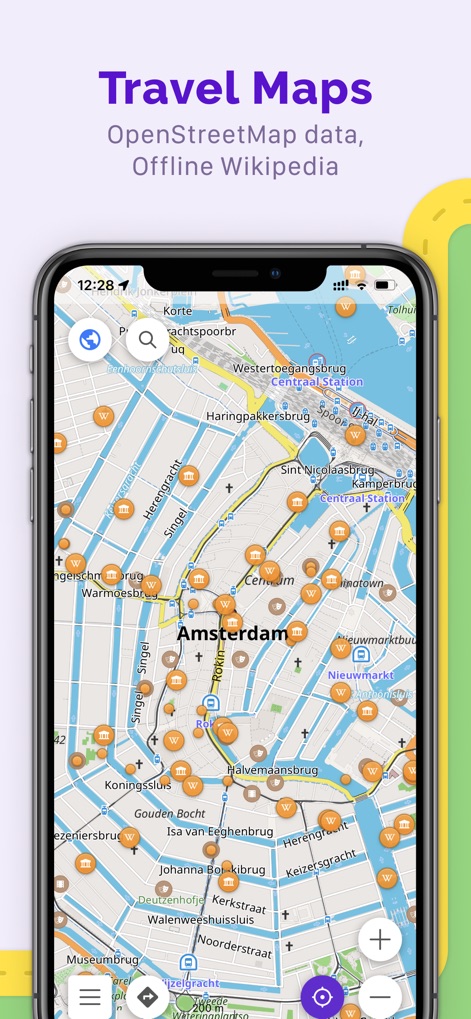
The app showcases detailed OpenStreetMap data with visible POI markers (e.g., Wikipedia entries) and a clear city layout.
Comprehensive Offline Maps

Users can effortlessly plan routes, choosing from various navigation profiles like car or bicycle, directly on an offline map.
Robust Offline Navigation
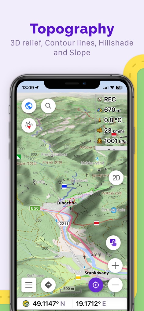
This tool provides comprehensive topographic details including contour lines and shaded relief, alongside real-time data like current altitude and temperature.
Advanced Topographic Views
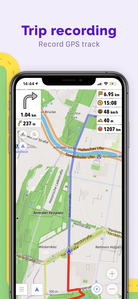
The app allows recording of GPX tracks, presenting visual data such as total distance covered and ascent/descent metrics for thorough trip analysis.
Track Your Adventures
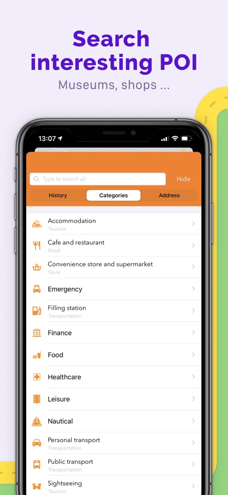
Users can easily discover points of interest by browsing through predefined categories like "Food" or "Healthcare", enhancing local exploration.
Discover Points of Interest

The app integrates practical travel utilities, including an accurate compass and customizable information widgets displaying speed and altitude.
Essential Travel Utilities
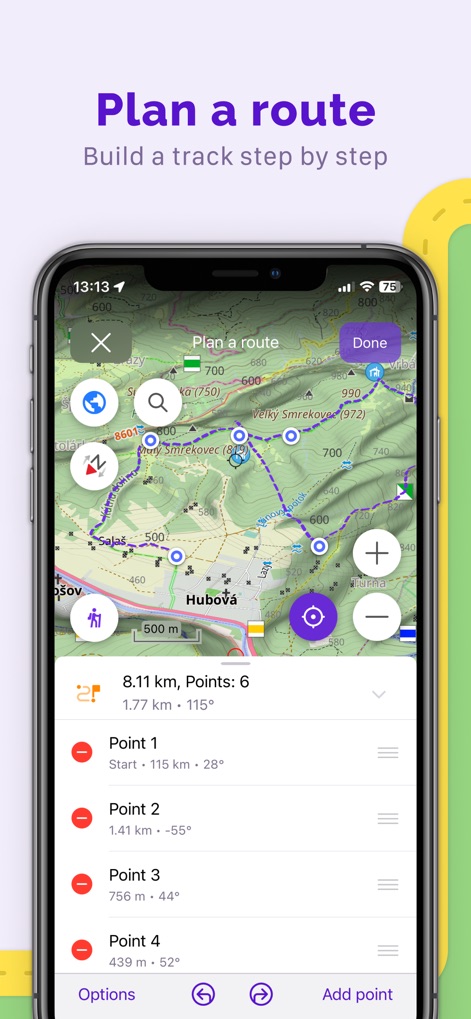
Users can build intricate routes by adding multiple waypoints step-by-step, with a clear display of total distance and point-specific details.
Custom Route Creation

The app enables users to set custom markers for specific locations, instantly providing directions and displaying the distance to the marked point.
Pinpoint Key Locations
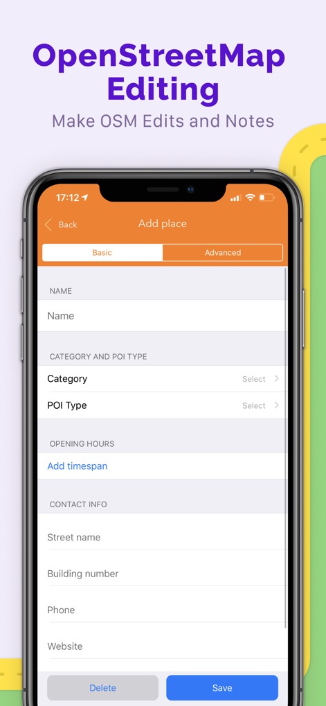
Users can directly contribute to OpenStreetMap by adding new places, completing fields for "Category" and "Contact Info" to enrich the map data.
Contribute to OpenStreetMap

The app offers "OsmAnd Live" features, allowing users to configure update frequency (e.g., hourly) and manage updates via Wi-Fi for fresh map data.
Real-Time Map Refresh
Description
Download
More Like This
Apps with similar features and user experience

AllTrails: Hike, Bike & Run
AllTrails, Inc.

Pedometer++
Cross Forward Consulting, LLC

Organic Maps: Offline Map
Organic Maps OU

Gaia GPS: Mobile Trail Maps
Trailbehind, INC.

Offline hiking maps: Mapy.com
Seznam.cz a.s.

Hiking Map Poland
Mapa Turystyczna sp. z o.o.

MapOut
Valnova GmbH

FarOut: Offline GPS Trail Maps
Atlas Guides DE, Inc.

Norgeskart
Norgeskart AS
This page is not an official page of the app or its developer, but an independent editorial publication created for informational and commentary purposes. Unless expressly stated otherwise, neither the app nor its developer is affiliated with, endorsed by, sponsored by, authorized by, or otherwise officially connected with MWM, Apple, Google Play, the app publisher, or the app's developer, and nothing on this page implies that the app was developed using MWM's services. Any trademarks, logos, screenshots, and other content remain the property of their respective owners.