This page is not an official page of the app or its developer, but an independent editorial publication created for informational and commentary purposes. Unless expressly stated otherwise, neither the app nor its developer is affiliated with, endorsed by, sponsored by, authorized by, or otherwise officially connected with MWM, Apple, Google Play, the app publisher, or the app's developer, and nothing on this page implies that the app was developed using MWM's services. Any trademarks, logos, screenshots, and other content remain the property of their respective owners.

swisstopo
No more fumbling with paper maps. The app puts Switzerland's rugged terrain at your fingertips, making you master of every trail.
Downloads
1M+User Rating
Total Ratings
1.5KPublisher
Category
NavigationLocales
4Latest Version
1.23.0Size
102.0 MBFirst Released
Jul 22, 2020An analytical overview of essential functionalities for outdoor enthusiasts and specialized users in Switzerland.
Key Features of swisstopo App
Offline Map Access
The app ensures reliable navigation and safety in remote areas by providing free access to its comprehensive maps offline, eliminating dependency on internet connectivity.
Aviation and Drone Data
This tool features critical safety and regulatory data, including aeronautical charts, obstacles, airspaces, landing sites, and drone restrictions, essential for pilots and drone operators.
Comprehensive Topographical Maps
The app provides access to famous national maps across all scales (1:10,000 to 1:1 million), current aerial imagery, and historical maps for comprehensive spatial awareness and planning.
Official Routes and Trail Information
It features official hiking, mountain biking, snowshoe, ski routes, and SwitzerlandMobility routes, including real-time closures, facilitating safe and informed planning for various activities.
Custom Tour Planning and Tracking
The app allows users to draw, record, import, and share custom tours, enabling personalized route creation and sharing of outdoor experiences.
Real-time Tour Guidance
This tool enables users to set tour types and personal pace, offering real-time guidance such as estimated arrival times and remaining distances for efficient navigation.
Search and Measurement Tools
It features robust tools for measuring distances, comparing locations, and searching geographical names, addresses, or coordinates, aiding precise planning and analysis.
3D Terrain Visualization
The app offers an immersive panorama mode with labelled views and 3D visualization of tours, enhancing terrain understanding and route assessment.
Frequently Asked Questions
Everything you need to know about swisstopo
Has the swisstopo app received any awards?
Yes, the swisstopo app won the "Master of Swiss Apps 2021" award, recognizing its quality and functionality.
Is the swisstopo app free to use?
Yes, all functions, data, and offline use of the swisstopo app are completely free of charge.
Does the swisstopo app require a login or display ads?
No, the swisstopo app is free of advertising and does not require users to create an account or log in.
What map scales are available in the swisstopo app?
The swisstopo app offers comprehensive national maps covering all scales from 1:10,000 to 1:1 million.
Does the swisstopo app include historical maps?
Yes, the swisstopo app provides current aerial images and historical maps, enhancing navigation and exploration.
What outdoor activity routes does the swisstopo app offer?
The swisstopo app includes official hiking, mountain hiking, alpine hiking trails, snowshoe routes, and ski routes.
Does the swisstopo app show hiking trail closures?
Yes, the swisstopo app displays current information regarding closures of hiking trails.
Can swisstopo app maps be used offline?
Yes, the swisstopo app offers free offline maps, available in scales from 1:25,000 to 1:1 million.
How do I plan and manage tours with the swisstopo app?
The swisstopo app allows users to draw, record, import, and share their own tours. Users can set tour type and personal pace.
Does the swisstopo app have a panorama mode?
Yes, the swisstopo app features a panorama mode with labelled views and the ability to view tours in 3D.
What search and measurement tools are available in the swisstopo app?
The swisstopo app provides tools for measuring, comparing, and searching geographical names, addresses, or coordinates.
What aviation-specific features does the swisstopo app offer?
The swisstopo app includes aeronautical charts, obstacles, airspaces, landing sites, and restrictions for drones and model aircrafts.
How can I get support for the swisstopo app?
Users can contact support for the swisstopo app by sending an email to support-cd@swisstopo.ch.
The following screenshots and description are sourced directly from the app's official store listing and are the property of the app developer.
App Store
Screenshots
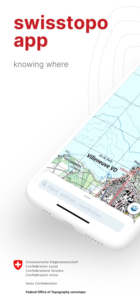
Discover the intuitive interface, showcasing the prominent search bar for geographical names and the clear map display.
App Navigation Start
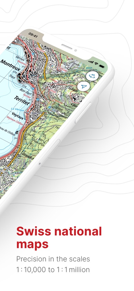
Explore the renowned Swiss national maps, presenting intricate topographical details and a range of precise scales from 1:10,000 to 1:1 million.
Precision Mapping Views

Access diverse mapping data through the integrated menu, offering specialized aeronautical charts and various background options like aerial images.
Specialized Data Layers

Experience the unique panorama mode, providing labeled mountain peaks with altitudes and a 3D tour visualization for enhanced exploration.
Immersive Panorama Views

Plan and track outdoor adventures with ease, featuring a detailed elevation profile and real-time tour guidance including arrival time and remaining distance.
Dynamic Tour Planning

Prepare for remote journeys with robust offline map capabilities, allowing users to download specific map sections and manage various map layers.
Seamless Offline Access
Description
Download
More Like This
Apps with similar features and user experience

AllTrails: Hike, Bike & Run
AllTrails, Inc.

Pedometer++
Cross Forward Consulting, LLC

Organic Maps: Offline Map
Organic Maps OU

Gaia GPS: Mobile Trail Maps
Trailbehind, INC.

Offline hiking maps: Mapy.com
Seznam.cz a.s.

Hiking Map Poland
Mapa Turystyczna sp. z o.o.

MapOut
Valnova GmbH

FarOut: Offline GPS Trail Maps
Atlas Guides DE, Inc.

Norgeskart
Norgeskart AS
This page is not an official page of the app or its developer, but an independent editorial publication created for informational and commentary purposes. Unless expressly stated otherwise, neither the app nor its developer is affiliated with, endorsed by, sponsored by, authorized by, or otherwise officially connected with MWM, Apple, Google Play, the app publisher, or the app's developer, and nothing on this page implies that the app was developed using MWM's services. Any trademarks, logos, screenshots, and other content remain the property of their respective owners.