This page is not an official page of the app or its developer, but an independent editorial publication created for informational and commentary purposes. Unless expressly stated otherwise, neither the app nor its developer is affiliated with, endorsed by, sponsored by, authorized by, or otherwise officially connected with MWM, Apple, Google Play, the app publisher, or the app's developer, and nothing on this page implies that the app was developed using MWM's services. Any trademarks, logos, screenshots, and other content remain the property of their respective owners.

行者戶外-騎行徒步跑步工具
Unleash your true potential: The app arms you with precise data and a thriving community, transforming every outdoor endeavor into a quantifiable triumph.
Downloads
7.5M+User Rating
Total Ratings
65.1KPublisher
Category
SportsLocales
3Latest Version
3.26.5Size
137.0 MBFirst Released
Mar 6, 2014An Analytical Overview of Core Functionalities for Outdoor Endurance Athletes
Key Features of 行者戶外-騎行徒步跑步工具
Advanced Activity Tracking & Performance Analysis
The app provides meticulous tracking of various outdoor activities, including cycling, hiking, and running. It records detailed metrics such as movement trajectory, power data, altitude curves, and slope ratings, allowing for in-depth post-activity review and analysis. This tool supports connection with external sensors like speedometers, heart rate monitors, and cadence sensors for comprehensive data capture.
Offline Route Navigation & Discovery
This tool features an extensive library of millions of outdoor routes and "roadbooks" for cycling and hiking worldwide. It allows users to discover new trails and navigate offline, ensuring they stay on track even without an internet connection, effectively preventing getting lost during their adventures.
Comprehensive Third-Party Device Integration
It offers compatibility with a wide range of third-party sports devices and sensors, including heart rate monitors, speedometers, and power meters. The app also allows for manual data import, providing a unified platform for managing all personal sports activities and performance data.
Vibrant Community & Social Interaction
The app fosters a thriving community where users can connect with millions of outdoor enthusiasts. It allows them to find and join local clubs, organize group activities and rides, and engage in discussions through a large forum, promoting shared experiences and mutual improvement.
Gamified Challenges & Achievements
It provides various gamified elements to motivate users, including online races, challenges (monthly and annual), and a system of hundreds of personalized badges and achievements. These features encourage participation, competition, and goal setting, rewarding users for their efforts.
Event & Race Registration Platform
This tool enables users to easily discover and register for thousands of cycling, running, and trail running competitions throughout the year with a simple one-click process, streamlining participation in organized events.
Extensive Sports Knowledge Base
The app includes a rich knowledge base with tens of thousands of articles and expert columns on various sports topics. It offers insights into the latest scientific and avant-garde sports knowledge, helping users improve their training and understanding.
Integrated Sports Gear Store
It features an in-app marketplace offering authentic sports equipment, including exclusive high-tech smart sports gear. This allows users to conveniently purchase necessary items, often with discounts that increase with their activity level.
Frequently Asked Questions
Everything you need to know about 行者戶外-騎行徒步跑步工具
What is the Xingzhe Outdoor app?
Xingzhe Outdoor is a comprehensive tool and community application for outdoor sports enthusiasts. It supports cycling, hiking, and running by recording activities, providing navigation, and connecting to various fitness devices.
Does Xingzhe Outdoor support offline navigation?
Yes, Xingzhe Outdoor offers offline navigation. It utilizes millions of roadbooks with outdoor routes covering global locations, enabling users to navigate without an internet connection.
Can Xingzhe Outdoor connect to external sports devices?
Yes, Xingzhe Outdoor connects to third-party sports equipment. It is compatible with most devices and supports manual data import, allowing for unified management of personal exercise data.
What types of data does Xingzhe Outdoor record for activities?
Xingzhe Outdoor records diverse activity data. This includes exercise routes, power data, heart rate, cadence, altitude curves, and slope ratings. It also provides tools for data review and analysis.
Does Xingzhe Outdoor integrate with Apple HealthKit?
Yes, Xingzhe Outdoor integrates with HealthKit. This feature allows users to synchronize their recorded exercise data directly to the iPhone system's health application for centralized tracking.
Can users find and join sports clubs through Xingzhe Outdoor?
Xingzhe Outdoor helps users find clubs. It lists hundreds of thousands of cycling and running clubs, making it easy for users to discover and join suitable communities.
What is the PRO exclusive feature in Xingzhe Outdoor?
The "PRO exclusive" feature in Xingzhe Outdoor provides advanced slope analysis. This allows users to analyze detailed slope ratings and elevation profiles for their outdoor activities.
Does Xingzhe Outdoor provide 3D terrain playback for activities?
Yes, Xingzhe Outdoor offers a "Real-scene Playback REAR" feature. This enables users to review their recorded activities using a 3D terrain view, providing an immersive perspective.
The following screenshots and description are sourced directly from the app's official store listing and are the property of the app developer.
App Store
Screenshots
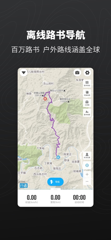
Users can confidently navigate new terrain with offline route guidance and explore millions of pre-planned routes covering the globe.
Global Offline Routes
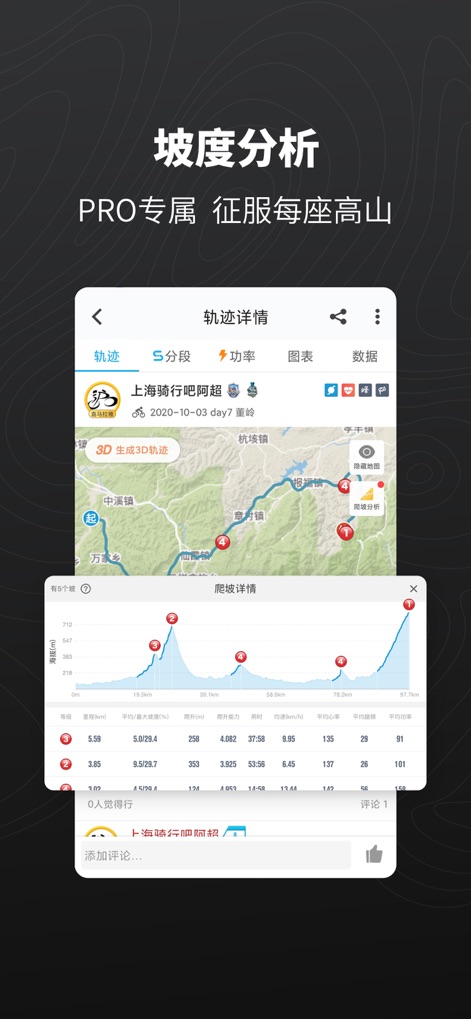
The app provides detailed slope analysis with a comprehensive elevation profile graph and a metric table for in-depth performance review.
Advanced Slope Insights
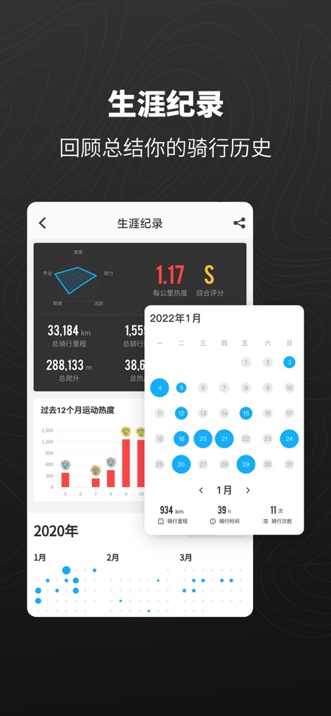
This tool offers a complete career record with an intuitive performance radar chart and a monthly activity calendar for easy review.
Comprehensive Career Record

Experience routes in an immersive way with 3D terrain visualization and a dynamic route replay feature showing speed and elevation profiles.
Immersive 3D Replay
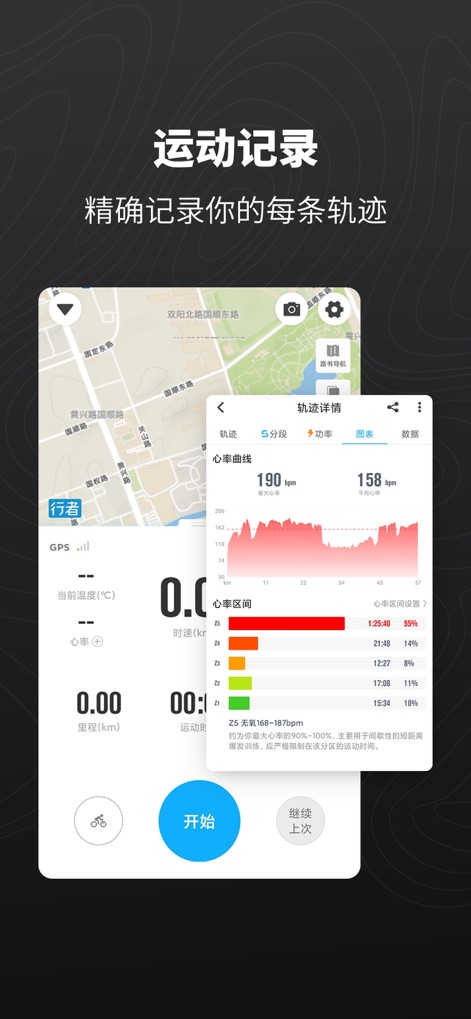
The app precisely records every track, displaying a real-time heart rate curve and detailed heart rate zone breakdown for optimal training.
Precise Activity Tracking
Description
Download
More Like This
Apps with similar features and user experience

AllTrails: Hike, Bike & Run
AllTrails, Inc.

Pedometer++
Cross Forward Consulting, LLC

Organic Maps: Offline Map
Organic Maps OU

Gaia GPS: Mobile Trail Maps
Trailbehind, INC.

Offline hiking maps: Mapy.com
Seznam.cz a.s.

Hiking Map Poland
Mapa Turystyczna sp. z o.o.

MapOut
Valnova GmbH

FarOut: Offline GPS Trail Maps
Atlas Guides DE, Inc.

Norgeskart
Norgeskart AS
This page is not an official page of the app or its developer, but an independent editorial publication created for informational and commentary purposes. Unless expressly stated otherwise, neither the app nor its developer is affiliated with, endorsed by, sponsored by, authorized by, or otherwise officially connected with MWM, Apple, Google Play, the app publisher, or the app's developer, and nothing on this page implies that the app was developed using MWM's services. Any trademarks, logos, screenshots, and other content remain the property of their respective owners.