This page is not an official page of the app or its developer, but an independent editorial publication created for informational and commentary purposes. Unless expressly stated otherwise, neither the app nor its developer is affiliated with, endorsed by, sponsored by, authorized by, or otherwise officially connected with MWM, Apple, Google Play, the app publisher, or the app's developer, and nothing on this page implies that the app was developed using MWM's services. Any trademarks, logos, screenshots, and other content remain the property of their respective owners.

专业指南针-GPS北斗定位海拔测量导航
Command your location, wherever the journey takes you. This app transforms your device into an unwavering guide and record keeper.
Downloads
500k+User Rating
Total Ratings
463Publisher
Category
UtilitiesLocales
3Latest Version
1.1.0Size
42.6 MBFirst Released
Sep 21, 2025A comprehensive evaluation of key features designed for outdoor exploration and daily utility.
App Analysis: 专业指南针-GPS北斗定位海拔测量导航
Geo-tagged Photo Camera
It allows users to automatically add time, location, altitude, and precise coordinates as watermarks to photos, enabling detailed documentation of travel and adventure moments with geographical context.
Precise Digital Compass
The app provides a high-precision electronic compass that offers real-time directional guidance, ensuring users never lose their way, whether in rugged wilderness or urban environments.
Real-time GPS/Beidou Positioning (Altitude, Latitude, Longitude)
This tool features real-time display of current altitude, latitude, and longitude coordinates, offering precise geographical information essential for professional outdoor exploration and accurate travel logging.
Real-time Local Weather Updates
It provides real-time weather information for the user's current location, including temperature, humidity, and wind force, which is crucial for effective trip planning and understanding environmental conditions.
Frequently Asked Questions
Everything you need to know about 专业指南针-GPS北斗定位海拔测量导航
What is 专业指南针-GPS北斗定位海拔测量导航?
专业指南针-GPS北斗定位海拔测量导航 is a versatile outdoor navigation and life assistant app. It features an accurate compass, real-time altitude/coordinates, a smart leveler, real-time weather, and a watermark camera.
Does 专业指南针-GPS北斗定位海拔测量导航 provide an accurate compass?
Yes, the 专业指南针 app integrates a high-precision electronic compass. It provides real-time direction, ensuring users always know their heading, whether in mountains or cities.
Can 专业指南针 display current altitude and coordinates?
Yes, the 专业指南针 app displays real-time altitude, longitude, and latitude coordinates. This feature allows users to precisely understand their geographical information during outdoor exploration and travel.
Does the 专业指南针 app include a level measurement tool?
Yes, the 专业指南针 app includes a smart leveler tool. It easily detects the horizontal state of surfaces, which is useful for home decorating and equipment installation tasks.
How does 专业指南针 help with weather information?
The 专业指南针 app provides current location weather details like temperature, humidity, and wind power. This real-time data helps users plan their outings and travels effectively.
Can I add location data to photos using 专业指南针?
Yes, the 专业指南针 app has a watermark camera feature. It automatically embeds time, location, altitude, and coordinates onto photos, documenting every travel moment with geographical context.
What are the benefits of a VIP membership in 专业指南针?
Subscribing to VIP membership in 专业指南针 unlocks all premium features and high-definition output capabilities. This enhances the app's functionality for a more advanced user experience.
How do I manage or cancel my 专业指南针 subscription?
To manage or cancel your 专业指南针 subscription, navigate to Apple's "Settings" → "iTunes Store & App Store" → "Apple ID" → "View Apple ID" → "Account Settings" → "Subscriptions".
Where can I find the privacy policy for 专业指南针?
The privacy policy for 专业指南针 is available via a direct link. Users can access comprehensive information regarding data handling and privacy practices at https://docs.qq.com/doc/DY1VRd2ZFaGx4eFFo.
The following screenshots and description are sourced directly from the app's official store listing and are the property of the app developer.
App Store
Screenshots
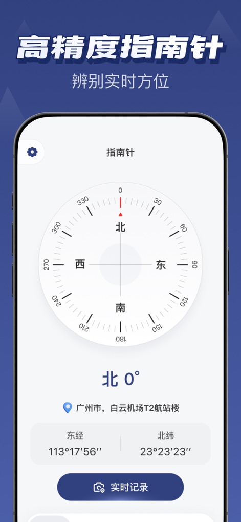
Discover how the app provides a high-precision compass dial for real-time direction and displays exact longitude and latitude coordinates.
Precise Direction Guide
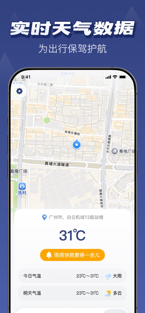
The app offers critical real-time weather information, featuring a location-aware map and detailed daily temperature forecasts.
Dynamic Weather Insights
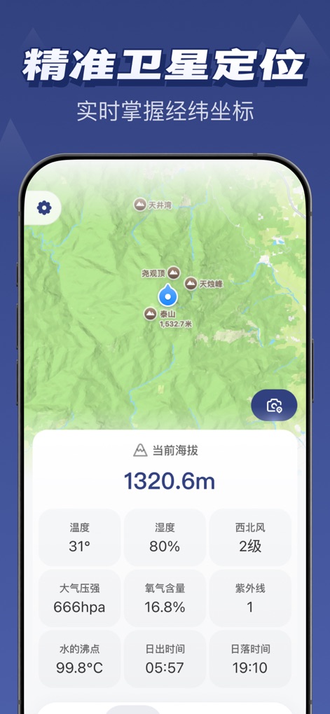
Users can access precise satellite positioning data, observing their current altitude and various environmental metrics like oxygen content and atmospheric pressure.
Advanced GPS Tracking
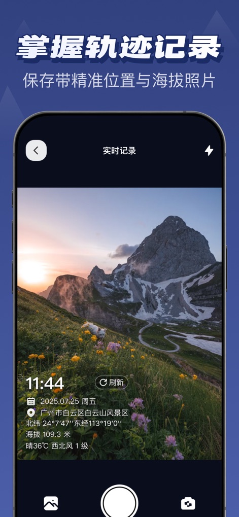
This tool enables users to document their adventures with a geo-tagged photo, embedding details like location and altitude directly onto the image via the integrated camera interface.
Adventure Photo Journal
Description
Download
More Like This
Apps with similar features and user experience

Realtime Altimeter
Zhenlai Xia

Travel Camera & Compass
Ha Nguyen

compass-latitude and longitude
美霞 熊

Compass ×
DOUBLE U s.r.o.

GPS Altitude-海拔表
祥琦 孔

Compass: GPS & Altimeter
Shanghai BRC Internet Technology Co., Ltd.

Travel Altimeter & Elevation
BranchenKing Ltd.

Compass - GPS positioning
嘉 罗

Compass360X-GPS Speedometer
卫豪 吴
This page is not an official page of the app or its developer, but an independent editorial publication created for informational and commentary purposes. Unless expressly stated otherwise, neither the app nor its developer is affiliated with, endorsed by, sponsored by, authorized by, or otherwise officially connected with MWM, Apple, Google Play, the app publisher, or the app's developer, and nothing on this page implies that the app was developed using MWM's services. Any trademarks, logos, screenshots, and other content remain the property of their respective owners.