이 페이지는 앱이나 개발자의 공식 페이지가 아니며, 정보 제공 및 논평을 목적으로 작성된 독립 편집 간행물입니다. 명시적으로 달리 언급되지 않는 한, 해당 앱이나 개발자는 MWM, Apple, Google Play, 앱 퍼블리셔 또는 앱 개발자와 제휴, 보증, 후원, 승인 또는 공식적으로 연결되어 있지 않으며, 이 페이지의 어떤 내용도 해당 앱이 MWM의 서비스를 사용하여 개발되었음을 의미하지 않습니다. 모든 상표, 로고, 스크린샷 및 기타 콘텐츠는 해당 소유자의 자산입니다.

GOHUNT: Research & Maps
당신은 더 이상 어둠 속에서 사냥하지 않습니다. 이 앱은 사냥꾼에게 디지털 통찰력의 망원경을 부여합니다.
다운로드
250k+사용자 평점
총 평가 수
8.4K개발사
카테고리
Navigation지원 언어
1최신 버전
12.0.0크기
302.1 MB출시일
2021년 5월 3일이 앱은 심층적인 연구, 전략적 계획, 그리고 현장 탐색을 지원하는 핵심 기능을 제공하여 경험 많은 사냥꾼들의 성공적인 사냥을 돕습니다.
GOHUNT: Research & Maps 앱 분석: 전문 사냥꾼을 위한 통합 솔루션
서부 주 추첨 확률 및 포인트 추적기
이 앱은 서부 주에 대한 추첨 확률 정보와 포인트 추적기 기능을 제공하여, 사용자가 태그 추첨 시스템에서 성공 가능성을 높이고 누적 포인트를 효율적으로 관리할 수 있도록 돕습니다.
미국 전역 공공/사유지 경계 GPS 매핑
이 도구는 미국 50개 주 전체의 공공 및 사유지 경계를 포함한 상세 GPS 매핑 기능을 갖추고 있어, 사용자가 현장에서 정확하게 위치를 파악하고 토지 접근을 관리할 수 있게 해줍니다.
사냥 단위 고급 검색 및 필터링
이 앱은 사용자가 원하는 사냥 단위(unit)를 찾기 위해 고급 검색 및 필터링 도구를 제공하여, 추첨 확률, 공공 토지 비율, 과거 수확 성공률 등 다양한 기준으로 단위를 선별할 수 있게 해줍니다.
상세 사냥 관련 지도 레이어
이 도구는 토지 소유권, 정부 토지, 종 분포, 도로 및 산책로, 고도대, 수자원, 산불 정보 등 다양한 사냥 관련 레이어를 제공하여, 사용자가 특정 지역에 대한 포괄적인 분석을 수행할 수 있도록 지원합니다.
오프라인 지도 다운로드
이 앱은 오프라인 지도 다운로드 기능을 제공하여, 사용자가 휴대폰 신호가 없는 원격 지역에서도 지도 및 위치 정보를 계속 사용할 수 있게 해줍니다.
단위 프로필 및 사용자 소통
이 앱은 서부 지역의 각 사냥 단위에 대한 상세 프로필을 제공하며, 여기에는 단위별 설명, 사진, 역사적 데이터 및 사용자 간 소통 기능이 포함되어 있어 심층적인 연구와 커뮤니티 통찰을 돕습니다.
자주 묻는 질문
에 대해 알아야 할 모든 것 GOHUNT: Research & Maps
How does GOHUNT help users find hunting units?
GOHUNT's research platform helps users find units by selecting a state and species. They can filter results by draw odds, public land percentage, and historical harvest success, then view suitable units directly in the mapping platform.
Does GOHUNT provide maps for all 50 US states?
Yes, the GOHUNT mapping platform includes comprehensive map coverage for all 50 US states. It provides essential details such as public and private land boundaries, hunt units, and various environmental layers.
Can GOHUNT users share waypoints with others?
Yes, GOHUNT allows users to share waypoints, tracks, and entire hunts with other GOHUNT users. This feature enables collaboration and organization of hunting plans within the app.
Does GOHUNT offer a free trial?
Yes, GOHUNT offers a 7-day free trial upon signup. Users can access and try all the features of the application during this period before deciding on a subscription.
What mapping layers are available in the GOHUNT app?
GOHUNT offers various map layers including land ownership, government land, species distribution, roads and trails, elevation bands, water sources, and wildfire data. These layers enhance planning and navigation.
Can I use GOHUNT maps offline?
Yes, GOHUNT provides downloadable offline maps. This feature ensures users can navigate and access critical map information even in areas without cellular service or internet connectivity, facilitating remote hunts.
How can GOHUNT assist with hunt research and filtering?
GOHUNT offers advanced search and filtering tools for hunt research. Users can filter by draw odds, public land, and historical harvest success, find unit profiles, and access application strategies and deadlines.
Does GOHUNT track user movements?
Yes, GOHUNT includes accurate GPS tracking. Users can record and save their tracks, which displays detailed information such as distance, time, speed, and elevation of their movements during a hunt.
다음 스크린샷과 설명은 앱의 공식 스토어 목록에서 직접 가져온 것이며 앱 개발자의 자산입니다.
앱 스토어
스크린샷

사용자는 이 도구에서 사냥할 종(Elk)과 사냥 도구(Bow)를 선택하여 맞춤형 사냥을 계획할 수 있습니다.
사냥 계획 시작
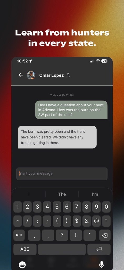
이 앱은 사용자 간 직접 메시징 기능을 통해 동료 사냥꾼들과 지역 특정 정보(Arizona) 및 현장 경험(burn on the SW part of the unit)을 공유할 수 있도록 지원합니다.
전문가와 소통
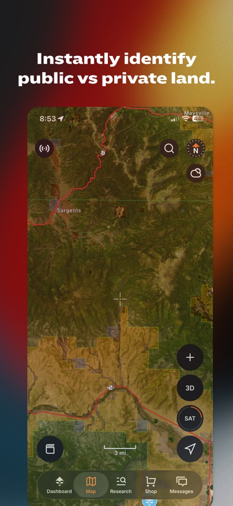
사용자는 지도에서 공공 토지 및 개인 토지 경계를 명확하게 식별하고, 위성 지도(SAT)를 활용하여 지형을 상세하게 파악할 수 있습니다.
토지 유형 즉시 확인

이 도구는 신호가 없는 환경에서도 상세한 등고선(contour lines)과 지형 정보(topographical basemap)를 제공하여 정확한 길 찾기를 가능하게 합니다.
오프라인 정밀 지도

사용자는 이 앱에서 특정 지역(Unit 1)에 대한 상세한 팁(Quick Tips)과 사진(6 Photos)을 포함한 유닛 분석 정보를 확인할 수 있습니다.
상세한 단위 프로필

이 앱은 사용자가 지원하기 전에 각 사냥 구역의 당첨 확률(Draw Odds)과 신청 마감일(Apply by March 15)을 제공하여 전략적인 결정을 내릴 수 있도록 돕습니다.
당첨 확률 예측
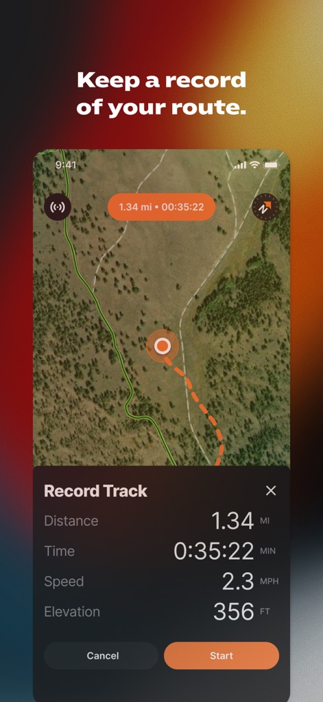
사용자는 자신의 이동 경로(recorded track)를 기록하여 거리(Distance) 및 시간(Time)과 같은 핵심 정보를 분석하고 추후 사냥 계획에 활용할 수 있습니다.
사냥 경로 기록

이 앱은 사용자가 지도에 위치 지정(Buck, Glassing)을 하고 웨이포인트(Waypoint)를 추가하여 동료 사냥꾼들과 사냥 계획을 효율적으로 공유할 수 있게 합니다.
사냥 계획 공유
설명
Download
비슷한 앱
유사한 기능과 사용자 경험을 가진 앱

onX Hunt: GPS Hunting Maps
onXmaps, Inc.

HuntWise: A Better Hunting App
Sportsman Tracker, Inc

HuntStand: GPS Maps & Tools
Good Sportsman Marketing, LLC

MyHunt: US Best Hunting App
Hunter & Companion Gesellschaft mit beschrankter Haftung

WeHunt
Natlink AB

DeerCast-Prep. Predict. Pursue
Good Sportsman Marketing, LLC

BaseMap: Hunting GPS Maps
BaseMap Inc

iHunter
Inside Outside Studios Inc.

Hunting Points: GPS & Hunt App
Fishing Points d.o.o.
이 페이지는 앱이나 개발자의 공식 페이지가 아니며, 정보 제공 및 논평을 목적으로 작성된 독립 편집 간행물입니다. 명시적으로 달리 언급되지 않는 한, 해당 앱이나 개발자는 MWM, Apple, Google Play, 앱 퍼블리셔 또는 앱 개발자와 제휴, 보증, 후원, 승인 또는 공식적으로 연결되어 있지 않으며, 이 페이지의 어떤 내용도 해당 앱이 MWM의 서비스를 사용하여 개발되었음을 의미하지 않습니다. 모든 상표, 로고, 스크린샷 및 기타 콘텐츠는 해당 소유자의 자산입니다.