이 페이지는 앱이나 개발자의 공식 페이지가 아니며, 정보 제공 및 논평을 목적으로 작성된 독립 편집 간행물입니다. 명시적으로 달리 언급되지 않는 한, 해당 앱이나 개발자는 MWM, Apple, Google Play, 앱 퍼블리셔 또는 앱 개발자와 제휴, 보증, 후원, 승인 또는 공식적으로 연결되어 있지 않으며, 이 페이지의 어떤 내용도 해당 앱이 MWM의 서비스를 사용하여 개발되었음을 의미하지 않습니다. 모든 상표, 로고, 스크린샷 및 기타 콘텐츠는 해당 소유자의 자산입니다.

HuntStand: GPS Maps & Tools
이 앱은 당신이 숲의 지배자가 되도록 만듭니다.
다운로드
1M+사용자 평점
총 평가 수
59.4K개발사
카테고리
Sports지원 언어
1최신 버전
8.0.71크기
216.3 MB출시일
2013년 12월 19일고급 사냥 및 토지 관리를 위한 핵심 기능 평가
HuntStand: GPS 지도 및 도구 앱 분석
전국 사유지 경계선
이 앱은 미국 50개 주와 대부분의 캐나다 지역에 대한 전국적인 사유지 경계선, 공공 및 사유지 경계 지도를 제공하여 사용자가 법적으로 사냥할 수 있는 지역을 파악하고 무단 침입을 방지할 수 있도록 돕습니다.
무제한 오프라인 지도
이 앱은 인터넷 연결 없이 사용할 수 있도록 지도를 무제한으로 저장하는 기능을 제공하여, 원격 사냥 지역에서 안정적인 탐색을 보장합니다.
GPS 매핑
사용자는 이 기능을 통해 자신의 위치를 확인하고, 이동 경로를 추적하며, 사냥 스탠드, 블라인드 및 기타 주요 지점에 마커를 추가하여 현장에서의 탐색 및 위치 관리를 용이하게 할 수 있습니다.
독점 발정기 지도
이 도구는 흰꼬리사슴, 엘크, 노새사슴, 검은꼬리사슴에 대한 카운티별 발정기 지도를 각 단계의 상세한 날짜와 함께 제공하여 사냥꾼이 가장 활동적인 시기에 사냥감을 효과적으로 목표할 수 있도록 돕습니다.
헌트존 풍향 예측
이 앱은 최대 72시간 전까지 시간별 풍향 예측을 제공하여 사냥감이 냄새를 맡을 가능성을 예측하고 사냥 성공률을 높이기 위한 향기 관리 전략 수립에 필수적인 정보를 제공합니다.
고급 사냥감 활동 예측
이 도구는 사용자의 정확한 위치에 대한 흰꼬리사슴, 엘크, 노새사슴, 그리고 검은꼬리사슴의 15일 활동 예측을 독점적으로 제공하여 사냥 계획을 최적화하고 성공률을 높이는 데 기여합니다.
월별 위성 이미지
이 앱은 월별 위성 업데이트와 수년간의 과거 이미지를 통해 사냥터의 변화를 확인할 수 있도록 지원하며, 이는 정찰 및 잠재적인 사냥감 패턴 분석에 매우 유용합니다.
토지 소유권 데이터
이 앱은 토지 소유자 정보를 확인하고 이름으로 검색할 수 있는 기능을 제공하여, 토지 관리자 및 허가를 구하는 사냥꾼에게 매우 유용한 정보를 제공합니다.
3D 매핑
이 도구는 역동적인 3D 지형을 '비행하듯' 탐색할 수 있는 3D 매핑 기능을 갖추고 있어, 지형을 더 잘 이해하고 다양한 관점에서 정찰하는 데 도움을 줍니다.
디지털 거리 측정기
이 도구는 현장에서 즉시 거리를 계산할 수 있는 디지털 거리 측정 기능을 제공하여, 사냥꾼이 정확한 사격 위치를 결정하고 윤리적인 사냥을 할 수 있도록 지원합니다.
자주 묻는 질문
에 대해 알아야 할 모든 것 HuntStand: GPS Maps & Tools
Is HuntStand recognized as a top hunting app?
Yes, HuntStand is North America’s #1 Hunting & Land Management App. Outdoor Life Magazine recognized HuntStand as the Best App for Hunters.
Does HuntStand include property line maps?
Yes, HuntStand offers nationwide property lines, public and private boundaries, and public land maps for all 50 states and most of Canada.
How much does HuntStand Pro cost annually?
HuntStand Pro costs $29.99 per year. This premium membership provides advanced mapping tools and nationwide coverage, including property ownership data.
Can HuntStand access historical satellite imagery?
Yes, HuntStand provides monthly satellite imagery updates and archives years of historical imagery. This allows users to observe changes in their hunting grounds over time.
Does HuntStand include game activity forecasts?
Yes, HuntStand offers exclusive 15-day activity forecasts for whitetail, elk, mule deer, and blacktail, tailored to your exact location for optimal hunting strategy.
Is the HuntStand app free to download?
Yes, the HuntStand app is free to install. Users can download it and begin mapping their hunting areas today without any initial cost.
Where can I find HuntStand's privacy policy?
HuntStand's Privacy Policy is available for review at the provided URL: https://huntstand.com/privacy. This ensures transparency regarding data handling.
Can I share hunt areas with others using HuntStand?
Yes, HuntStand allows users to share hunt areas seamlessly with buddies, lease partners, and family, facilitating collaborative hunting and land management.
What is the annual price for HuntStand Ultimate?
HuntStand Ultimate costs $99.99 per year. This premium subscription includes all HuntStand Pro features plus exclusive tools like advanced rut maps and whitetail habitat maps.
Does HuntStand offer 3D mapping capabilities?
Yes, HuntStand Pro offers 3D mapping functionality. This feature allows users to 'fly through' terrain in dynamic 3D for enhanced scouting and planning.
다음 스크린샷과 설명은 앱의 공식 스토어 목록에서 직접 가져온 것이며 앱 개발자의 자산입니다.
앱 스토어
스크린샷
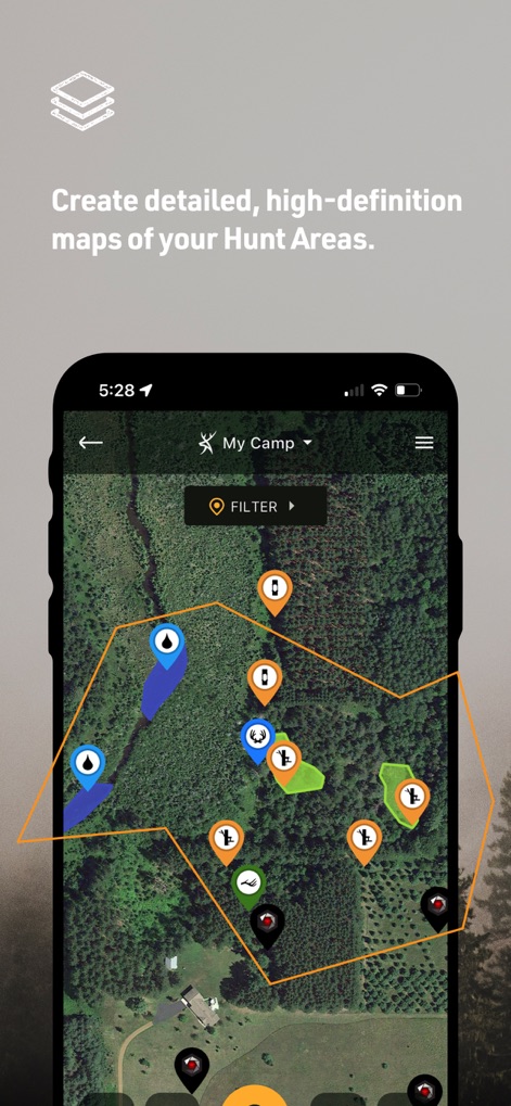
사용자는 위성 지도에서 사냥 구역을 맞춤 설정하고, 다양한 관심 지점 마커를 활용하여 지역을 효과적으로 계획할 수 있습니다.
맞춤 사냥 구역

이 앱은 토지 소유주 정보를 제공하며, 상세한 주소와 경계선을 통해 특정 필지의 소유자(JOHN HUNTER)와 면적(40.50 에이커)을 확인할 수 있도록 돕습니다.
토지 소유권 정보

사용자는 과거 위성 이미지 아카이브에 접근하여 특정 연도(2017)의 지형 변화를 확인하고, 월별(7월) 업데이트를 통해 사냥터의 변천사를 파악할 수 있습니다.
월별 위성 탐색

이 앱은 Outdoor Life Magazine으로부터 '최고의 사냥 앱'으로 선정되어 그 우수성을 입증했으며, 사용자 평점 별 4개로 높은 만족도를 보여줍니다.
최고 사냥 앱
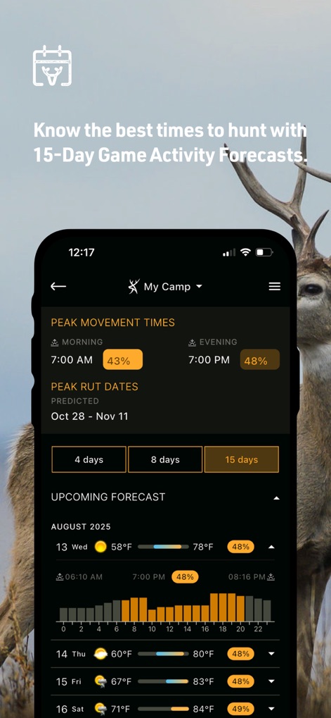
사용자는 15일 활동 예측 기능을 통해 특정 날짜의 최고 이동 시간(오전 7시, 오후 7시)을 파악하고, 일별 기온(58°F, 78°F) 및 활동 확률을 상세하게 확인할 수 있습니다.
15일 활동 예보

이 앱은 카운티별 발정기 데이터를 포함하는 강력한 백미 사슴 지도를 제공하며, 사용자는 다양한 색상 오버레이를 통해 지역별 활동 패턴을 시각적으로 확인하고, 사냥 구역을 추가할 수 있습니다.
사슴 서식지 지도

GearJunkie.com은 이 앱을 '토지 소유주를 위한 최고의 사냥 앱'으로 평가하며 그 유용성을 강조했고, 이는 토지 관리에 있어 핵심적인 도구임을 나타냅니다.
지주를 위한 앱

사용자는 지도에서 잠재적인 사냥 구역(노란색으로 강조된 부분)을 쉽게 식별하고, 특정 토지의 면적(1123 에이커)과 유형(VPA / THAP PROPERTY)에 대한 상세 정보를 확인할 수 있습니다.
새로운 사냥터

이 앱은 고급 3D 매핑 기술을 활용하여 사용자에게 입체적인 지형 정보를 제공하며, 다양한 마커(사슴, 사람 아이콘)를 통해 사냥 지역을 더욱 효과적으로 정찰할 수 있도록 돕습니다.
고급 3D 지도

사용자는 현재 날씨(대체로 맑음)를 포함한 상세 기상 조건을 확인하고, 향후 10일간의 최고 기온(64°F)과 최저 기온(53°F)을 일별 아이콘과 함께 쉽게 파악할 수 있습니다.
10일 날씨 예측
설명
Download
비슷한 앱
유사한 기능과 사용자 경험을 가진 앱

onX Hunt: GPS Hunting Maps
onXmaps, Inc.

GOHUNT: Research & Maps
GOHUNT, LLC

HuntWise: A Better Hunting App
Sportsman Tracker, Inc

MyHunt: US Best Hunting App
Hunter & Companion Gesellschaft mit beschrankter Haftung

WeHunt
Natlink AB

DeerCast-Prep. Predict. Pursue
Good Sportsman Marketing, LLC

BaseMap: Hunting GPS Maps
BaseMap Inc

iHunter
Inside Outside Studios Inc.

Hunting Points: GPS & Hunt App
Fishing Points d.o.o.
이 페이지는 앱이나 개발자의 공식 페이지가 아니며, 정보 제공 및 논평을 목적으로 작성된 독립 편집 간행물입니다. 명시적으로 달리 언급되지 않는 한, 해당 앱이나 개발자는 MWM, Apple, Google Play, 앱 퍼블리셔 또는 앱 개발자와 제휴, 보증, 후원, 승인 또는 공식적으로 연결되어 있지 않으며, 이 페이지의 어떤 내용도 해당 앱이 MWM의 서비스를 사용하여 개발되었음을 의미하지 않습니다. 모든 상표, 로고, 스크린샷 및 기타 콘텐츠는 해당 소유자의 자산입니다.