이 페이지는 앱이나 개발자의 공식 페이지가 아니며, 정보 제공 및 논평을 목적으로 작성된 독립 편집 간행물입니다. 명시적으로 달리 언급되지 않는 한, 해당 앱이나 개발자는 MWM, Apple, Google Play, 앱 퍼블리셔 또는 앱 개발자와 제휴, 보증, 후원, 승인 또는 공식적으로 연결되어 있지 않으며, 이 페이지의 어떤 내용도 해당 앱이 MWM의 서비스를 사용하여 개발되었음을 의미하지 않습니다. 모든 상표, 로고, 스크린샷 및 기타 콘텐츠는 해당 소유자의 자산입니다.

onX Hunt: GPS Hunting Maps
이 앱은 당신이 서 있는 곳이 어디든 지도를 손에 쥐게 하여, 사냥터를 정복할 수 있는 전략적 이점을 제공합니다.
다운로드
10M+사용자 평점
총 평가 수
276.4K개발사
카테고리
Navigation지원 언어
1최신 버전
26.13.0크기
496.8 MB출시일
2013년 8월 7일테크 분석가가 평가한 사냥꾼 필수 앱의 주요 기술적 강점
onX Hunt: GPS Hunting Maps 앱 분석: 전략적 사냥을 위한 핵심 기능
전국 토지 경계 및 소유권 데이터
이 앱은 미국 및 캐나다 전역의 사유지 및 공공 토지 경계 데이터를 제공하여, 사용자가 법적 사냥 구역을 정확히 식별하고 무단 침입을 방지할 수 있도록 돕습니다. 토지 소유자 정보까지 확인할 수 있어 접근 권한 관리에도 용이합니다.
고급 GPS 내비게이션 및 오프라인 지도
이 도구는 상세한 3D 지형도(위성, 라이다 지형도, 하이브리드)와 정밀한 GPS 기능을 갖추고 있어, 사용자가 사냥터의 복잡한 지형을 완벽하게 이해하고 탐색할 수 있게 해줍니다. 모바일 신호가 없는 원격 지역에서도 오프라인 지도를 통해 길을 잃지 않고 정확한 위치를 파악할 수 있습니다.
엘리트 회원 전용 고급 분석 도구
엘리트 회원을 위해 이 앱은 TerrainX 3D 뷰어, 최신 위성 이미지, 경로 빌더, 사슴 이동 예측과 같은 독점적인 고급 도구를 제공합니다. 이를 통해 사용자는 최첨단 지형 분석과 전략적 사냥 계획을 수립할 수 있습니다.
사냥 연구 및 통계 도구
이 앱은 사냥 추첨 확률, 태그 동향, 수확 통계 등 방대한 연구 자료를 제공하며, 엘리트 회원의 경우 'Huntin’ Fool'과 같은 전문가의 통찰력까지 활용할 수 있게 해줍니다. 사용자는 이러한 데이터를 바탕으로 사냥 시즌 전 성공적인 전략을 수립할 수 있습니다.
맞춤형 지도 레이어 및 지형 분석
사용자는 상태별 맞춤형 지도 레이어를 통해 기후, 접근 지점, 야생 동물 서식지, 토양 유형 등 다양한 환경 정보를 상세하게 분석할 수 있습니다. 또한, 특정 지점의 최적 바람 조건을 설정하는 기능은 사냥 계획의 효율성을 극대화합니다.
종 및 사냥 구역 정보
이 도구는 특정 종의 서식지 데이터와 함께 일반 사냥 구역(GMU), 주(州) 사냥 지도 등 포괄적인 사냥 구역 정보를 제공합니다. 이를 통해 사용자는 지역 사냥 규정을 준수하고 목표하는 사냥감을 효율적으로 추적할 수 있습니다.
현장 실행 지원 및 실시간 날씨
이 앱은 현장에서의 사냥 실행을 돕기 위해 실시간 시간별 날씨 예보를 제공하며, 트래커 기능을 통해 사용자의 이동 경로를 기록하여 안전과 추후 분석에 기여합니다. 나침반 모드는 정확한 방향 감각을 유지하는 데 필수적인 기능을 제공합니다.
타사 장치 연동 및 협업 기능
이 앱은 트레일 카메라, 거리 측정기, 쌍안경 등 다양한 외부 사냥 장치와 연동되어 실시간 데이터를 얻을 수 있습니다. 또한, Apple CarPlay를 통한 차량 대시보드 지도 표시와 사냥 마크업 공유 기능은 팀원 간의 협업과 효율적인 작전 수행을 지원합니다.
자주 묻는 질문
에 대해 알아야 할 모든 것 onX Hunt: GPS Hunting Maps
What is onX Hunt?
onX Hunt is a GPS hunting app designed for planning hunts and navigating in the field. It provides species distribution, 3D maps, hunting units, and nationwide land boundaries.
Does onX Hunt show private land boundaries?
Yes, onX Hunt provides access to private land boundary data and property line maps, including landowner names, for U.S. states where available.
Can I use onX Hunt without cell service?
Yes, onX Hunt allows users to save detailed Offline Maps. This feature enables navigation and map use in areas without cell service.
What types of maps does onX Hunt offer?
onX Hunt offers satellite, lidar topo, and hybrid Basemaps. Users can view terrain in both 2D and 3D, and save custom Offline Maps.
How do I get a free trial for onX Hunt?
Users can start a seven-day free trial of onX Hunt by installing the app and selecting their desired state within the application.
Does onX Hunt integrate with trail cameras?
Yes, onX Hunt integrates with compatible tools such as Moultrie trail cameras. Users can view images in real-time and receive key insights.
What is the Elite Nationwide Membership for onX Hunt?
The Elite Nationwide Membership for onX Hunt offers proprietary maps for all 50 states and Canada, TerrainX 3D Viewer, Route Builder, and Elite-exclusive pro deals.
Can onX Hunt display wind conditions?
Yes, onX Hunt allows users to monitor weather and set optimal wind conditions on any Waypoint. It provides forecasts and a wind calendar.
How does onX Hunt help identify hunting areas?
onX Hunt helps identify new hunting areas by targeting nutrient-rich soil with its Historic Wildfire Layer and using custom Map Layers for wildlife distribution, trees, crops, or soil.
What are the GPS tools available in onX Hunt?
onX Hunt provides GPS tools to mark Waypoints, track progress, measure distances, and calculate area shapes. It also includes features like Line Distance and Compass Mode.
다음 스크린샷과 설명은 앱의 공식 스토어 목록에서 직접 가져온 것이며 앱 개발자의 자산입니다.
앱 스토어
스크린샷
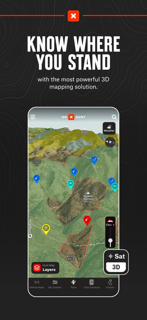
이 앱의 가장 강력한 3D 매핑 솔루션으로 사용자는 자신의 위치를 정확히 파악하고, 겹겹이 쌓인 레이어와 위성 뷰를 통해 지형을 시각화할 수 있습니다.
강력한 3D 매핑

상세한 지주 정보와 함께 사유지 경계를 명확하게 표시하여, 사용자는 토지 소유자 이름과 정확한 좌표를 확인할 수 있습니다.
사유지 경계 확인

BLM, 국유림, 주립 토지 등 다양한 공공 토지를 탐색하고, 사용자는 지도의 지형 정보와 하이브리드 베이스맵을 통해 이동 경로를 계획할 수 있습니다.
공공 토지 탐색
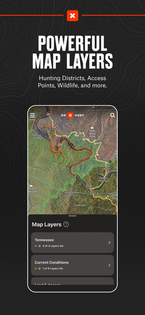
사냥 구역, 접근 지점, 야생 동물 등 강력한 맵 레이어를 활용하여, 사용자는 텐네시와 같은 특정 지역의 현재 조건을 쉽게 확인할 수 있습니다.
맞춤형 맵 레이어
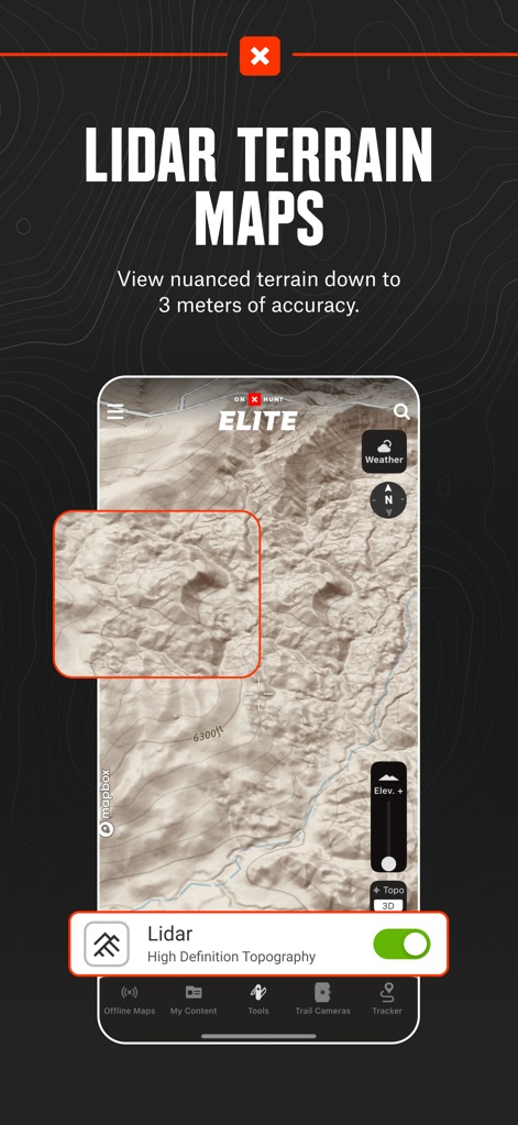
3미터 정확도의 미묘한 지형을 볼 수 있는 라이다 지형도를 통해, 사용자는 고해상도 지형 데이터를 활용하여 복잡한 지형을 분석할 수 있습니다.
정밀한 라이다 지형

웨이포인트별 최적 풍향 설정과 함께 상세한 날씨 예측을 확인하여, 사용자는 풍향 달력을 통해 특정 날짜의 바람 조건을 비교할 수 있습니다.
상세한 날씨 예측

웨이포인트를 표시하고 진행 상황을 추적하며 거리를 측정하는 다목적 GPS 도구를 통해, 사용자는 나침반 모드와 경로 생성 기능을 활용할 수 있습니다.
다목적 GPS 도구

휴대폰 서비스가 필요 없는 오프라인 지도를 다운로드하여, 사용자는 토포(Topo)와 같은 다양한 상세 수준으로 지도를 저장할 수 있습니다.
오프라인 지도 접근

도토리를 생산하는 참나무와 같은 수목 종 분포를 찾아, 사용자는 열 보호 구역을 식별하고 지도의 색상 코드를 통해 정보를 얻을 수 있습니다.
수목 종 분포도
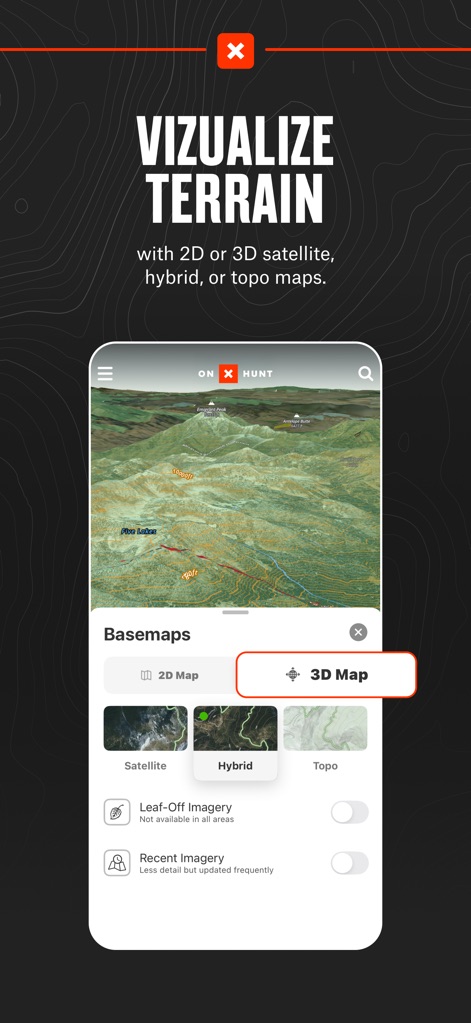
2D 또는 3D 위성, 하이브리드, 지형도 등 다양한 베이스맵으로 지형을 시각화하여, 사용자는 위성 뷰와 하이브리드 맵을 전환하며 최적의 시야를 확보할 수 있습니다.
다양한 지형 시각화
설명
Download
비슷한 앱
유사한 기능과 사용자 경험을 가진 앱

GOHUNT: Research & Maps
GOHUNT, LLC

HuntWise: A Better Hunting App
Sportsman Tracker, Inc

HuntStand: GPS Maps & Tools
Good Sportsman Marketing, LLC

MyHunt: US Best Hunting App
Hunter & Companion Gesellschaft mit beschrankter Haftung

WeHunt
Natlink AB

DeerCast-Prep. Predict. Pursue
Good Sportsman Marketing, LLC

BaseMap: Hunting GPS Maps
BaseMap Inc

iHunter
Inside Outside Studios Inc.

Hunting Points: GPS & Hunt App
Fishing Points d.o.o.
이 페이지는 앱이나 개발자의 공식 페이지가 아니며, 정보 제공 및 논평을 목적으로 작성된 독립 편집 간행물입니다. 명시적으로 달리 언급되지 않는 한, 해당 앱이나 개발자는 MWM, Apple, Google Play, 앱 퍼블리셔 또는 앱 개발자와 제휴, 보증, 후원, 승인 또는 공식적으로 연결되어 있지 않으며, 이 페이지의 어떤 내용도 해당 앱이 MWM의 서비스를 사용하여 개발되었음을 의미하지 않습니다. 모든 상표, 로고, 스크린샷 및 기타 콘텐츠는 해당 소유자의 자산입니다.