이 페이지는 앱이나 개발자의 공식 페이지가 아니며, 정보 제공 및 논평을 목적으로 작성된 독립 편집 간행물입니다. 명시적으로 달리 언급되지 않는 한, 해당 앱이나 개발자는 MWM, Apple, Google Play, 앱 퍼블리셔 또는 앱 개발자와 제휴, 보증, 후원, 승인 또는 공식적으로 연결되어 있지 않으며, 이 페이지의 어떤 내용도 해당 앱이 MWM의 서비스를 사용하여 개발되었음을 의미하지 않습니다. 모든 상표, 로고, 스크린샷 및 기타 콘텐츠는 해당 소유자의 자산입니다.

Moultrie
트레일 카메라 사진을 실질적인 정보로 바꾸십시오. 업계에서 가장 신뢰받는 사냥 생태계를 통해 셀룰러 카메라를 관리하고, 급이기를 모니터링하며, 바람을 완벽하게 파악하십시오.
다운로드
1M+사용자 평점
총 평가 수
28K+개발사
카테고리
Sports지원 언어
-최신 버전
6.0.0크기
171.5 MB출시일
2016년 4월 20일데이터 기반 정찰로 숲을 정복하십시오
트레일 카메라 관리, 개체군 정보 및 사냥 계획을 위한 업계 최첨단 생태계로 현장에서의 한정된 시간을 극대화하십시오.
AI 기반 이미지 분석
수천 장의 사진을 직접 분류하지 마십시오. 스마트 태그가 수사슴, 암사슴, 칠면조를 자동으로 식별하고 수사슴의 나이까지 추정하여 개체군을 정밀하게 관리할 수 있도록 도와줍니다.
예측 게임 플랜
추측은 그만두고 사냥을 시작하십시오. 과거 목격 정보, 달의 위상, 기압을 활용하여 피크 활동 시간대를 예측함으로써 언제 휴가를 내야 할지 정확히 알 수 있습니다.
자주 묻는 질문
에 대해 알아야 할 모든 것 Moultrie
Moultrie 앱이란 무엇인가요?
Moultrie 앱은 포괄적인 사냥 계획 도구이자 연결된 사냥 생태계입니다. 사용자가 게임 카메라를 관리하고, 피더를 제어하고, 데이터 기반 통찰력을 통해 사냥을 계획할 수 있도록 도와주며, 단순히 게임 카메라 사진을 보는 것 이상의 기능을 제공합니다.
Moultrie 앱은 무료 사냥 계획 도구를 제공하나요?
예, Moultrie 앱은 카메라나 구독 없이도 대화형 지도, 사진 라이브러리, 이미지 구성을 위한 스마트 태그, 활동 차트, 날씨 예보를 포함한 무료 사냥 계획 도구를 제공합니다.
Moultrie 앱으로 게임 카메라를 원격으로 관리할 수 있나요?
예, Moultrie 앱을 사용하면 셀룰러 게임 카메라를 원격으로 관리할 수 있습니다. 사용자는 즉시 알림을 받고, 온디맨드 사진/동영상을 요청하고, 어디서든 카메라 설정을 조정할 수 있습니다.
Moultrie 앱은 스마트 태그를 사용하여 어떤 종류의 이미지를 자동으로 식별할 수 있나요?
Moultrie 앱의 스마트 태그는 수사슴, 암사슴, 칠면조 및 기타 종의 이미지를 자동으로 식별하고 구성합니다. 효율적인 분석을 위해 수사슴의 나이별로 분류하기도 합니다.
Moultrie 앱은 사냥을 위한 바람 예보를 어떻게 도와주나요?
Moultrie 앱은 이상적인 바람 예보 기능을 제공합니다. 사용자는 스탠드에 대한 선호하는 바람 방향을 설정하고 실시간 및 7일간의 바람 예보를 받아 더 스마트하게 사냥을 계획하고 탐지를 피할 수 있습니다.
Moultrie 앱에는 속성선 정보가 포함되어 있나요?
예, Moultrie 앱은 고급 사냥 계획 도구로 지형 + 속성선을 제공합니다. 이 기능은 지형 오버레이와 함께 공공 및 사유지 경계를 표시합니다.
앱을 사용하여 Moultrie 피더를 원격으로 제어할 수 있나요?
예, Moultrie 앱은 블루투스 또는 셀룰러를 통해 연결된 피더를 원격으로 제어할 수 있습니다. 사용자는 사료량을 확인하고, 일정을 조정하고, 요청 시 사료를 공급하고, 문제 발생 시 알림을 받을 수 있습니다.
Moultrie 앱은 사슴의 움직임을 예측하는 데 어떻게 도움이 되나요?
Moultrie 앱의 게임 플랜 기능은 사슴의 높은 활동 기간을 예측합니다. 현지 게임 카메라 목격 정보와 날씨 데이터를 활용하여 사냥하기 가장 좋은 시간과 야외 활동 시간을 최대화할 수 있는 시간을 예측합니다.
Moultrie 앱은 어떤 종류의 활동 데이터를 제공하나요?
Moultrie 앱은 동물 목격 패턴을 식별하는 활동 차트를 제공합니다. 하루 중 시간, 달의 위상, 온도별 활동을 표시하여 대상 동물이 가장 활동적인 시간을 나타냅니다.
다음 스크린샷과 설명은 앱의 공식 스토어 목록에서 직접 가져온 것이며 앱 개발자의 자산입니다.
앱 스토어
스크린샷
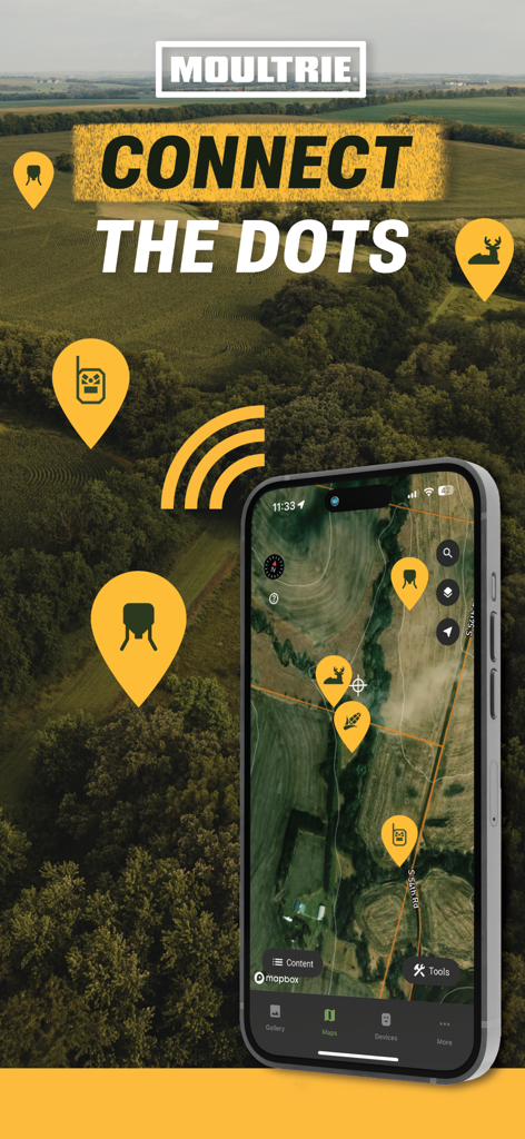
스마트폰에서 카메라와 야생동물 목격 위치에 핀이 표시된 대화형 사냥 지도를 보여주는 Moultrie 앱 인터페이스
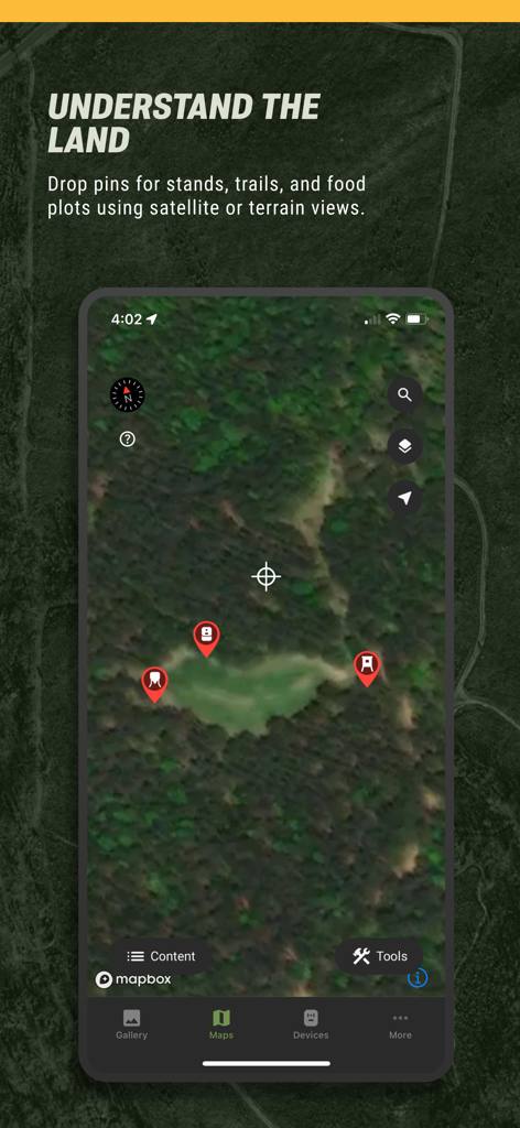
사냥용 대기 장소와 산책로에 핀이 표시된 위성 지도 뷰를 보여주는 Moultrie 모바일 앱
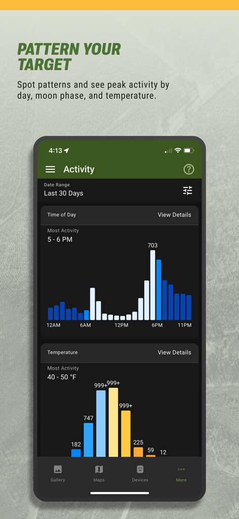
시간대 및 온도별 사슴 활동 차트를 보여주는 모바일 앱 화면
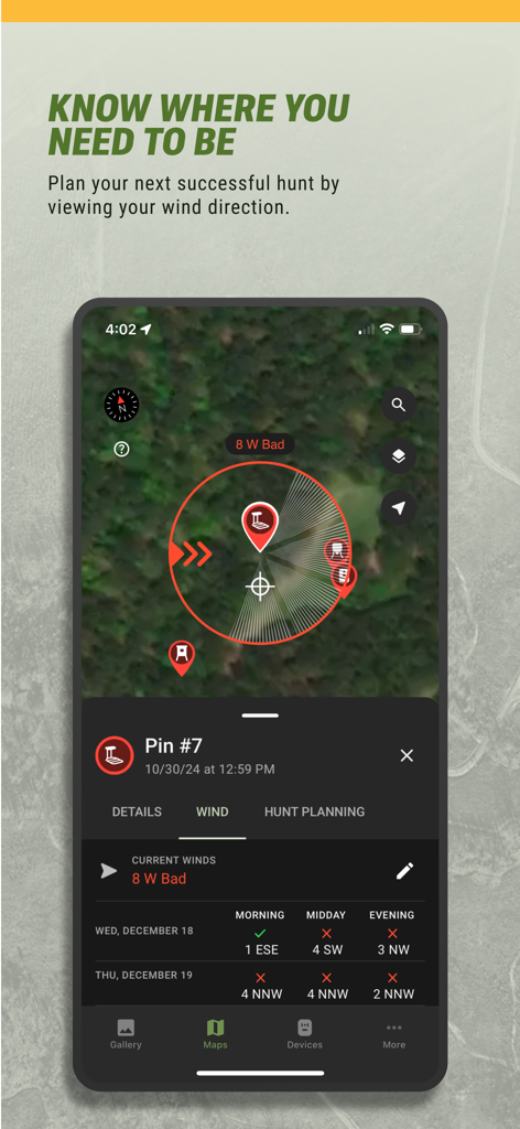
위성 지도에 풍향과 사냥 예보를 보여주는 Moultrie 앱 인터페이스
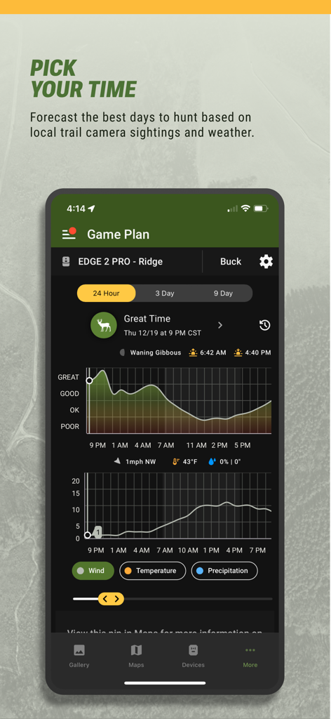
날씨 및 달의 위상 데이터와 함께 사슴 활동 예측 차트를 보여주는 Moultrie 앱 Game Plan 기능의 스크린샷
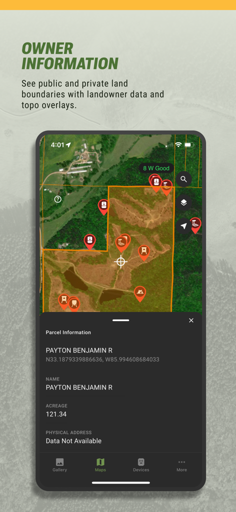
위성 지도에 토지 경계와 소유주 정보를 보여주는 Moultrie 앱 인터페이스
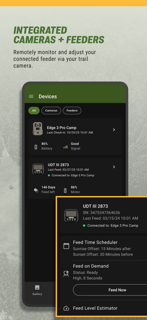
트레일 카메라 및 자동 급이기의 원격 관리를 위한 Moultrie 앱 인터페이스
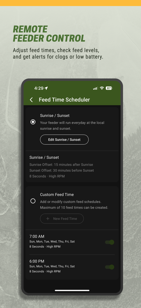
사냥용 급이기를 원격으로 관리하기 위한 Moultrie 앱의 급이 시간 스케줄러를 보여주는 스마트폰 화면
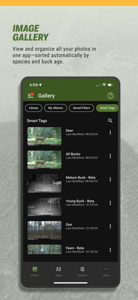
사슴 종 및 수사슴 나이 분류를 위한 자동 스마트 태그를 보여주는 Moultrie 앱 이미지 갤러리의 스크린샷
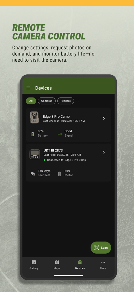
배터리 및 신호 세기를 보여주는 원격 카메라 및 급이기 관리를 위한 Moultrie 앱 인터페이스
설명
Download
비슷한 앱
유사한 기능과 사용자 경험을 가진 앱

onX Hunt: GPS Hunting Maps
onXmaps, Inc.

GOHUNT: Research & Maps
GOHUNT, LLC

HuntWise: A Better Hunting App
Sportsman Tracker, Inc

HuntStand: GPS Maps & Tools
Good Sportsman Marketing, LLC

MyHunt: US Best Hunting App
Hunter & Companion Gesellschaft mit beschrankter Haftung

WeHunt
Natlink AB

DeerCast-Prep. Predict. Pursue
Good Sportsman Marketing, LLC

BaseMap: Hunting GPS Maps
BaseMap Inc

iHunter
Inside Outside Studios Inc.
이 페이지는 앱이나 개발자의 공식 페이지가 아니며, 정보 제공 및 논평을 목적으로 작성된 독립 편집 간행물입니다. 명시적으로 달리 언급되지 않는 한, 해당 앱이나 개발자는 MWM, Apple, Google Play, 앱 퍼블리셔 또는 앱 개발자와 제휴, 보증, 후원, 승인 또는 공식적으로 연결되어 있지 않으며, 이 페이지의 어떤 내용도 해당 앱이 MWM의 서비스를 사용하여 개발되었음을 의미하지 않습니다. 모든 상표, 로고, 스크린샷 및 기타 콘텐츠는 해당 소유자의 자산입니다.