This page is not an official page of the app or its developer, but an independent editorial publication created for informational and commentary purposes. Unless expressly stated otherwise, neither the app nor its developer is affiliated with, endorsed by, sponsored by, authorized by, or otherwise officially connected with MWM, Apple, Google Play, the app publisher, or the app's developer, and nothing on this page implies that the app was developed using MWM's services. Any trademarks, logos, screenshots, and other content remain the property of their respective owners.

3D实况卫星导航-指南针北斗智能语音导航
Navigation, reimagined. This app redefines travel with pinpoint accuracy and an explorer's toolkit.
Downloads
750k+User Rating
Total Ratings
3.9KPublisher
Category
NavigationLocales
3Latest Version
1.0.7Size
140.5 MBFirst Released
Aug 28, 2025An Analytical Overview for Drivers, Travelers, and Outdoor Enthusiasts
Key Features of 3D Live Satellite Navigation
Live 3D Voice Navigation
The app provides true 3D road conditions with detailed models of roads, overpasses, and buildings, offering clear guidance even in complex areas. It also features real-time traffic updates and precise voice announcements to ensure safe navigation.
High-definition Satellite Maps
This tool features seamless high-definition satellite views, allowing users to explore urban layouts, natural wonders, and geographical details from a 'God's-eye perspective'. It also allows free switching between standard, satellite, and traffic route maps.
Comprehensive Fishing Spot Database
It allows users to discover a vast collection of fishing spots nationwide, including wild ponds, reservoirs, rivers, and sea fishing locations. Users can quickly query nearby spots, check fishing ground types, and fish species information.
National Scenic Spot Guide
The app provides distribution maps of popular and hidden scenic spots across the country, enabling users to easily plan journeys and learn about destinations in advance, enhancing their travel experiences.
Frequently Asked Questions
Everything you need to know about 3D实况卫星导航-指南针北斗智能语音导航
What is the primary function of 3D Live Satellite Navigation?
3D Live Satellite Navigation is an all-round travel explorer providing precise navigation, high-definition satellite views, fishing and travel exploration, and practical map tools. It integrates various features for a top-quality map experience.
Does 3D Live Satellite Navigation provide live 3D voice navigation?
Yes, 3D Live Satellite Navigation provides live 3D voice navigation. It features true 3D road conditions, real-time traffic updates, optimal route planning, and precise voice announcements for an immersive driving experience.
Can I view high-definition satellite maps with 3D Live Satellite Navigation?
Yes, 3D Live Satellite Navigation allows viewing high-definition satellite maps. Users can switch between standard, satellite, and traffic route map layers to see streets, buildings, mountains, and rivers clearly.
Does 3D Live Satellite Navigation list fishing spots?
Yes, 3D Live Satellite Navigation lists comprehensive fishing spots nationwide. It includes information on wild ponds, reservoirs, rivers, and sea fishing, allowing quick queries for nearby locations and fish species.
Does 3D Live Satellite Navigation feature information on scenic spots?
Yes, 3D Live Satellite Navigation includes a comprehensive list of national scenic spots. Users can query distribution maps of popular and niche attractions to plan their journeys effectively and learn about destination details.
What practical map tools are included in 3D Live Satellite Navigation?
3D Live Satellite Navigation includes a practical map toolbox. Features comprise real-time altitude measurement, a compass for direction identification, and a latitude and longitude camera for recording geographical coordinates in photos.
How much does an annual membership for 3D Live Satellite Navigation cost?
An annual membership subscription for 3D Live Satellite Navigation costs 198 yuan per year. This price is subject to automatic renewal through your iTunes account unless cancelled by the user.
What is the weekly membership price for 3D Live Satellite Navigation?
The weekly membership subscription price for 3D Live Satellite Navigation is 48 yuan per week. This service renews automatically via the user's iTunes account unless cancelled before the cycle ends.
How do I cancel my 3D Live Satellite Navigation subscription?
To cancel a 3D Live Satellite Navigation subscription, navigate to 'Settings' then 'Apple Account,' and select 'Subscriptions.' Find the corresponding subscription item and choose to cancel it there.
Does 3D Live Satellite Navigation offer real-time traffic information?
Yes, 3D Live Satellite Navigation offers real-time traffic information. The app updates this data to intelligently plan the optimal route and provide precise voice announcements for safe travel.
Can 3D Live Satellite Navigation measure altitude?
Yes, 3D Live Satellite Navigation can measure altitude. It provides real-time current altitude checks, useful for activities like climbing or hiking, as part of its practical map toolbox.
The following screenshots and description are sourced directly from the app's official store listing and are the property of the app developer.
App Store
Screenshots

The app offers detailed 3D road conditions and precise voice announcements, ensuring users navigate complex routes with clarity and confidence.
Immersive 3D Navigation

Explore the world from above with high-definition satellite maps, featuring clear views of buildings and seamless switching between multiple map layers.
Aerial Map Views
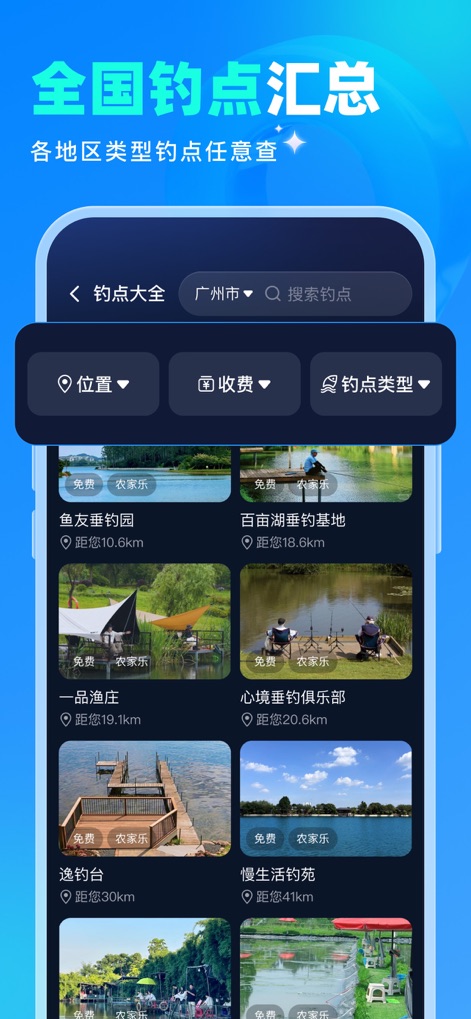
This tool provides a comprehensive list of nationwide fishing spots, allowing users to easily filter by location and view detailed information on each fishing ground.
Fishing Spot Finder

Discover national scenic spots with an interactive distribution map, showcasing both popular destinations and hidden gems for an enriching travel experience.
Scenic Spot Explorer
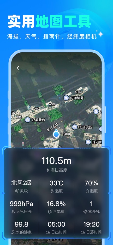
The app integrates practical tools like real-time altitude measurement and a comprehensive weather forecast, empowering outdoor enthusiasts with vital environmental data.
Essential Outdoor Tools
Description
Download
More Like This
Apps with similar features and user experience

AllTrails: Hike, Bike & Run
AllTrails, Inc.

Pedometer++
Cross Forward Consulting, LLC

Organic Maps: Offline Map
Organic Maps OU

Gaia GPS: Mobile Trail Maps
Trailbehind, INC.

Offline hiking maps: Mapy.com
Seznam.cz a.s.

Hiking Map Poland
Mapa Turystyczna sp. z o.o.

MapOut
Valnova GmbH

FarOut: Offline GPS Trail Maps
Atlas Guides DE, Inc.

Norgeskart
Norgeskart AS
This page is not an official page of the app or its developer, but an independent editorial publication created for informational and commentary purposes. Unless expressly stated otherwise, neither the app nor its developer is affiliated with, endorsed by, sponsored by, authorized by, or otherwise officially connected with MWM, Apple, Google Play, the app publisher, or the app's developer, and nothing on this page implies that the app was developed using MWM's services. Any trademarks, logos, screenshots, and other content remain the property of their respective owners.