This page is not an official page of the app or its developer, but an independent editorial publication created for informational and commentary purposes. Unless expressly stated otherwise, neither the app nor its developer is affiliated with, endorsed by, sponsored by, authorized by, or otherwise officially connected with MWM, Apple, Google Play, the app publisher, or the app's developer, and nothing on this page implies that the app was developed using MWM's services. Any trademarks, logos, screenshots, and other content remain the property of their respective owners.

Footpath Route Planner
No more guesswork. This app equips users with absolute control over their journeys, charting every turn and elevation before the first step.
Downloads
2.5M+User Rating
Total Ratings
58.4KPublisher
Category
NavigationLocales
12Latest Version
4.10.9Size
115.6 MBFirst Released
May 7, 2013An evaluation of key functionalities driving user engagement and utility for active individuals and outdoor enthusiasts.
Footpath Route Planner: Core Feature Analysis
Turn-by-Turn Offline Navigation
This tool offers reliable turn-by-turn navigation with audio cues on compatible devices, supporting completely offline use for uninterrupted guidance during activities.
Premium Offline Map Access
The app provides access to a wide range of premium offline maps, including topographic and 3D views, ensuring navigation capabilities even without an internet connection.
Intelligent Route Planning
The app provides intelligent route mapping, allowing users to trace a path with their finger or Apple Pencil, which then precisely snaps to existing roads and trails.
Extensive Data Import & Export
It supports extensive data import and export capabilities, including GPX, TCX, and FIT formats, facilitating seamless integration with external GPS devices and health platforms like Apple Health.
Comprehensive Performance Analysis
The app enables comprehensive activity tracking, recording GPS data, and providing detailed analysis of performance metrics such as speed, elevation, splits, and heart rate, alongside a calendar log of activities.
Detailed Distance & Elevation Profiling
It features detailed measurement tools for distance and elevation, including comprehensive elevation profiles, enabling users to plan routes tailored to their physical goals.
Advanced Route Management
It allows users to create, edit, and organize an unlimited number of saved routes into custom lists, streamlining planning for multiple activities or trips.
Seamless Route Sharing
The app allows users to easily share planned routes with friends or workout partners, enabling collaborative planning and group activities.
Frequently Asked Questions
Everything you need to know about Footpath Route Planner
How does Footpath Route Planner work for mapping routes?
Footpath enables users to map routes by tracing with a finger or Apple Pencil, which snaps to roads and trails. The app immediately provides precise distance and elevation measurements for effective planning.
Can Footpath Route Planner provide offline navigation?
Yes, Footpath Elite provides offline navigation. Users can download premium offline maps and save routes with audio cues in advance, ensuring voice guidance functions completely without an internet connection.
What features are included with a Footpath Elite subscription?
Footpath Elite includes turn-by-turn navigation, premium offline maps, unlimited route organization, activity analysis with HealthKit integration, and advanced export options for devices like Garmin and Wahoo.
Does Footpath Route Planner allow users to share routes?
Yes, Footpath enables users to share their planned routes with friends or workout partners. They can open these routes on their own devices directly, facilitating group activities.
Does Footpath Route Planner offer turn-by-turn navigation?
Yes, Footpath Elite offers turn-by-turn audio cues on iPhone and Apple Watch. It saves routes and cues in advance for voice guidance that operates completely offline.
What types of maps are available in Footpath Route Planner?
Footpath Elite provides 3D and topographic maps such as Footpath Outdoors, USGS Topo Maps, and OpenCycleMap. It also features cycling lanes, avalanche slope shading, and elevation contour lines.
Can Footpath Route Planner track and analyze my activities?
Yes, Footpath Elite records GPS tracks of activities and integrates with HealthKit for metrics like heart rate. Users access calendar logs, weekly summaries, and analyze splits, speed, and elevation.
How do I manage my Footpath Elite subscription?
Users manage their Footpath Elite monthly or yearly subscription via their iTunes account. Auto-renewal is turned off anytime through the "Manage Subscriptions" page in settings post-purchase.
Does Footpath Route Planner support exporting routes to other GPS devices?
Yes, Footpath Elite supports GPX import and export. It also facilitates TCX and FIT course export for turn-by-turn navigation directly on Garmin and Wahoo GPS devices.
What is the route saving limit in the free version of Footpath?
The free version of Footpath allows users to save up to 5 routes for reference. Footpath Elite subscribers gain the ability to save an unlimited number of routes.
The following screenshots and description are sourced directly from the app's official store listing and are the property of the app developer.
App Store
Screenshots

Users can effortlessly create custom paths by tracing a map with their finger, leveraging the app's intelligent snap-to-road functionality for precision.
Intuitive Route Design
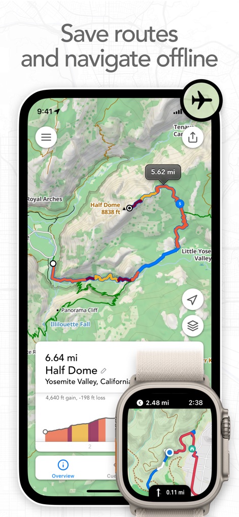
This tool allows users to download and save detailed routes for offline use, seamlessly integrating with Apple Watch for on-the-go navigation and essential metrics.
Offline Navigation Power
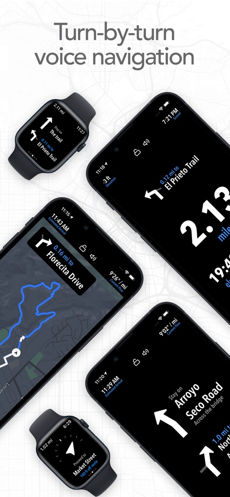
The app provides clear turn-by-turn voice navigation, offering precise directions and distance prompts on both iPhone and integrated Apple Watch displays.
Guided Journey

Explore the world with a vast array of global topographic maps, including specialized layers like nautical charts and detailed elevation contours for comprehensive planning.
Global Map Variety

Users can easily find new points of interest along their route, with detailed information pop-ups providing insights into features like Vernal Fall's elevation and description.
Discover Hidden Gems

This tool offers comprehensive activity logs for workouts and trips, providing detailed performance analysis graphs for metrics such as speed distribution and elevation changes.
Performance Insights

Relive past adventures with immersive 3D map visualizations, offering dynamic perspectives of terrains like Half Dome alongside detailed interactive elevation profile charts.
Immersive 3D Exploration

Showcase outdoor achievements with customizable shareable visual summaries, allowing users to personalize their posts with various map style overlays and route details.
Share Your Journey

The app facilitates seamless route sharing with friends and workout partners, offering direct integration with popular communication platforms like Message and Mail.
Connect & Share
Description
Download
More Like This
Apps with similar features and user experience

AllTrails: Hike, Bike & Run
AllTrails, Inc.

Pedometer++
Cross Forward Consulting, LLC

Organic Maps: Offline Map
Organic Maps OU

Gaia GPS: Mobile Trail Maps
Trailbehind, INC.

Offline hiking maps: Mapy.com
Seznam.cz a.s.

Hiking Map Poland
Mapa Turystyczna sp. z o.o.

MapOut
Valnova GmbH

FarOut: Offline GPS Trail Maps
Atlas Guides DE, Inc.

Norgeskart
Norgeskart AS
This page is not an official page of the app or its developer, but an independent editorial publication created for informational and commentary purposes. Unless expressly stated otherwise, neither the app nor its developer is affiliated with, endorsed by, sponsored by, authorized by, or otherwise officially connected with MWM, Apple, Google Play, the app publisher, or the app's developer, and nothing on this page implies that the app was developed using MWM's services. Any trademarks, logos, screenshots, and other content remain the property of their respective owners.