This page is not an official page of the app or its developer, but an independent editorial publication created for informational and commentary purposes. Unless expressly stated otherwise, neither the app nor its developer is affiliated with, endorsed by, sponsored by, authorized by, or otherwise officially connected with MWM, Apple, Google Play, the app publisher, or the app's developer, and nothing on this page implies that the app was developed using MWM's services. Any trademarks, logos, screenshots, and other content remain the property of their respective owners.

ForeFlight Mobile EFB
Join the elite community of VFR and IFR pilots who trust the industry standard. Elevate your situational awareness with advanced weather, 3D synthetic vision, and seamless flight filing—all in one mission-critical cockpit tool.
Downloads
1M+User Rating
Total Ratings
10K+Publisher
Category
WeatherLocales
3Latest Version
17.11.4Size
481.8 MBFirst Released
Dec 16, 2009The All-In-One Electronic Flight Bag
Streamline your cockpit workflow and enhance safety with a powerful, integrated suite of tools designed for the modern pilot.
Effortless Planning & Filing
Plan complex routes in seconds with intelligent advisors and file your flight plans directly with the FAA from your iPad or iPhone.
Next-Gen Hazard Awareness
Fly with total confidence using 3D Synthetic Vision and terrain alerts that provide a clear picture of your environment in all conditions.
Frequently Asked Questions
Everything you need to know about ForeFlight Mobile EFB
Does ForeFlight Mobile EFB offer a free trial?
Yes, ForeFlight Mobile EFB offers a 30-day free trial of its top subscription plan. Users can visit the website for more information on available plans and add-ons.
What flight planning features does ForeFlight offer?
ForeFlight provides Touch Planning on the Map, form-based Flights view, Route/Altitude/Procedure Advisors, graphical preflight briefing, and direct flight plan filing. It also generates professional-grade Navlogs for inflight reference.
Can ForeFlight display real-time weather information for pilots?
Yes, ForeFlight displays interactive weather layers including animated radar, global satellite, winds aloft, global icing, turbulence, and surface analysis. It also shows graphical AIR/SIGMETs, flight category, visibility, decoded METARs, TAFs, and MOS forecasts.
Does ForeFlight Mobile EFB provide navigational charts and maps?
Yes, ForeFlight includes data-driven Aeronautical Maps, VFR Sectionals, High/Low Enroute charts, SIDs, STARs, approach and taxi charts, and terrain, satellite, and street map views for both VFR and IFR operations.
Are geo-referenced approaches available in ForeFlight?
Yes, ForeFlight Mobile EFB supports geo-referenced approach and taxi charts. These charts display the real-time GPS location and can be overlaid on the Maps view along with weather and hazards for ultimate situational awareness.
How does ForeFlight Mobile EFB improve hazard awareness during flight?
ForeFlight enhances hazard awareness through its Global Hazard Awareness Technology. It integrates a Hazard Advisor map layer, Terrain Profile View, and 3D Synthetic Vision to depict terrain and obstacle hazards globally. Synthetic Vision provides a backup attitude display with an AHRS source.
Can pilots log their flights using the ForeFlight app?
Yes, the ForeFlight Logbook makes it easy for pilots to log and share flights, track hours, review currency, record certificates and ratings, and receive electronic instructor endorsements. Data automatically syncs across all devices.
What type of documents are available in ForeFlight Mobile EFB?
ForeFlight provides a built-in documents catalog including FAR/AIM and chart supplements. This allows for advanced document management within the app, ensuring pilots have essential references readily available.
Does ForeFlight include airport and FBO information?
Yes, ForeFlight provides comprehensive airport, FBO, and fuel price information for thousands of locations. This includes neatly organized airport details, METARs, TAFs, and MOS forecasts.
Is there a 3D flight preview feature in ForeFlight?
Yes, ForeFlight Mobile EFB offers an immersive 3D flight preview. This feature allows users to visualize their planned flight route in a three-dimensional environment before departure.
Does ForeFlight display live aircraft traffic?
Yes, ForeFlight Mobile EFB can stream live global aircraft traffic. This functionality provides pilots with enhanced situational awareness by displaying nearby aircraft.
What is the "Next-Gen Airport Familiarization" feature in ForeFlight?
ForeFlight offers "Next-Gen Airport Familiarization" through advanced visual tools. Screenshot #7 demonstrates this feature, providing a detailed 3D perspective to help pilots understand airport layouts and prepare for landings.
The following screenshots and description are sourced directly from the app's official store listing and are the property of the app developer.
App Store
Screenshots
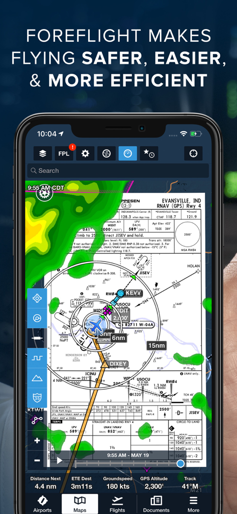
ForeFlight Mobile EFB app showing navigation map with weather radar and flight instrument data
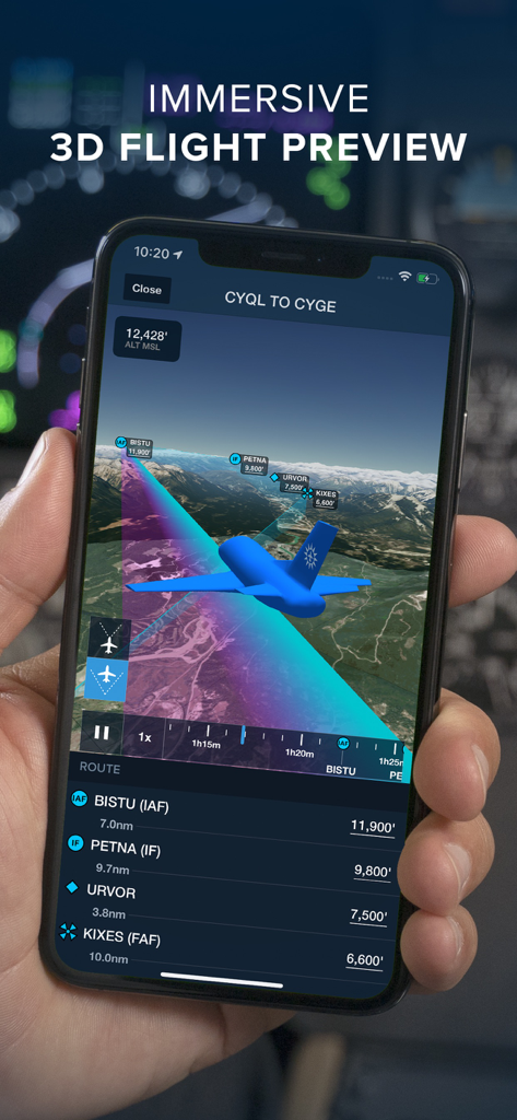
A pilot holding a smartphone showing the ForeFlight Mobile EFB immersive 3D flight preview feature over a mountainous terrain
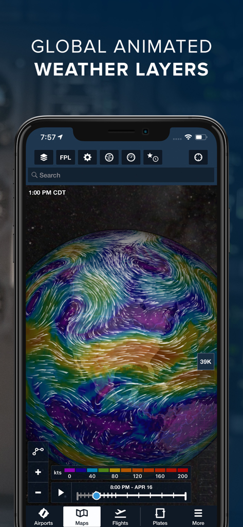
ForeFlight Mobile EFB interface displaying global animated weather layers and wind currents on a 3D globe
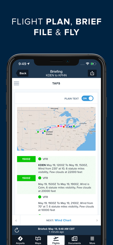
ForeFlight flight briefing interface with map route and TAF weather details
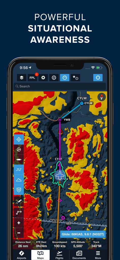
A smartphone screen displaying the ForeFlight Mobile EFB app with a situational awareness navigation map showing hazard terrain and flight route data
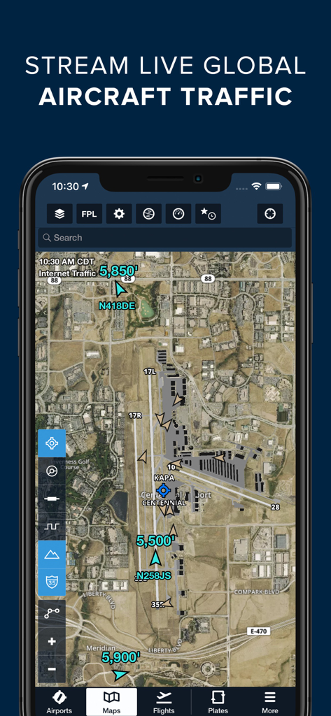
ForeFlight app displaying live global aircraft traffic over an airport satellite map
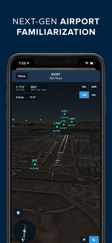
ForeFlight Mobile EFB showing 3D airport familiarization at night for KVNY Van Nuys
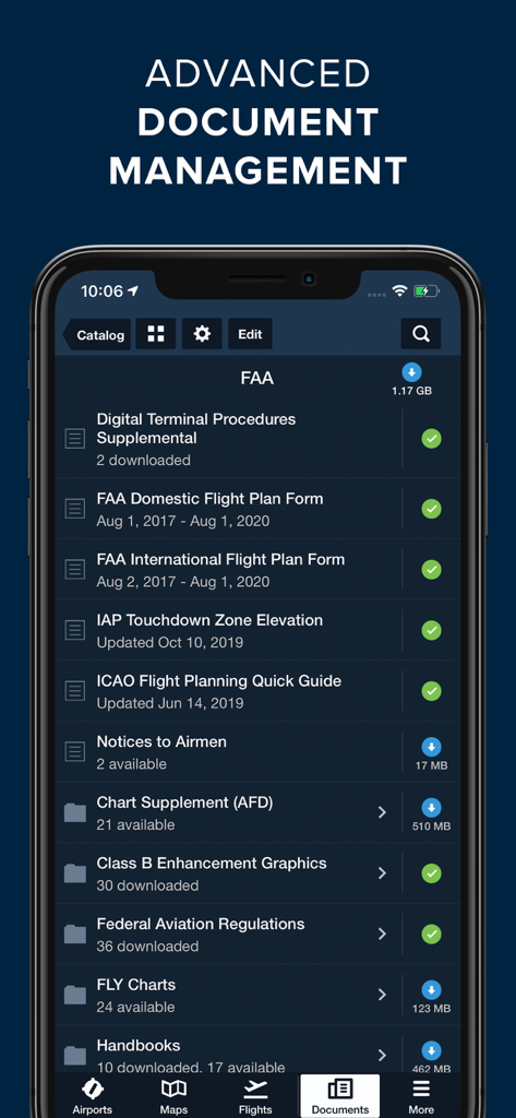
ForeFlight Mobile EFB app screen showing a digital library of FAA procedures and flight plan documents.
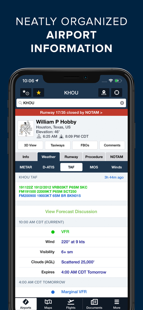
ForeFlight Mobile EFB displaying neatly organized airport information and weather data for pilots
Description
Download
More Like This
Apps with similar features and user experience

Navigraph Charts
Navigraph KB

SkyDemon
Divelements Limited

Airports
Applicate Ltd

OzRunways EFB
OzRunways Pty. Ltd.

fDeck: flight instruments
Darren Yeates

Noisy Goose
Automata Solutions Ltd.

StationWeather - METAR and TAF
Oliver Puetz

Drone UAV Fly Forecast: AirMap
MONIQ TAP COMPANY LIMITED

Airmate
Myriel Aviation SA
This page is not an official page of the app or its developer, but an independent editorial publication created for informational and commentary purposes. Unless expressly stated otherwise, neither the app nor its developer is affiliated with, endorsed by, sponsored by, authorized by, or otherwise officially connected with MWM, Apple, Google Play, the app publisher, or the app's developer, and nothing on this page implies that the app was developed using MWM's services. Any trademarks, logos, screenshots, and other content remain the property of their respective owners.