This page is not an official page of the app or its developer, but an independent editorial publication created for informational and commentary purposes. Unless expressly stated otherwise, neither the app nor its developer is affiliated with, endorsed by, sponsored by, authorized by, or otherwise officially connected with MWM, Apple, Google Play, the app publisher, or the app's developer, and nothing on this page implies that the app was developed using MWM's services. Any trademarks, logos, screenshots, and other content remain the property of their respective owners.

StationWeather - METAR and TAF
Stop decoding raw weather reports by hand. Get instant, visual briefings with interactive Live TAF timelines and intelligent NOTAM filtering tailored for your flight safety.
Downloads
459K+User Rating
Total Ratings
1K+Publisher
Category
WeatherLocales
4Latest Version
11.6Size
364.1 MBFirst Released
Jul 6, 2014Aviation Weather, Reimagined
Stop wasting time decoding raw data. Transform complex METARs, TAFs, and NOTAMs into intuitive, visual briefings that enhance your pre-flight safety and efficiency.
Visual Live TAF Decoding
Say goodbye to mental decoding of raw text strings. Our unique timeline interface decodes forecast assessments instantly, allowing you to visualize weather changes in seconds.
Smart NOTAM Management
Cut through the noise with intelligent sorting and color-coding. Use fully customizable filters to highlight only the NOTAMs critical to your specific flight operation.
Frequently Asked Questions
Everything you need to know about StationWeather - METAR and TAF
What weather data does StationWeather provide?
StationWeather provides METARs, TAFs, ATIS, NOTAMs, and Weather Radar. It also offers decoded reports, live TAFs, customizable NOTAM filters, and Apple Watch complications and widgets.
Does StationWeather decode raw weather reports?
Yes, StationWeather decodes raw METAR and TAF reports. It presents this data intuitively for faster, better briefings and a comprehensive understanding of current and forecast situations.
How does StationWeather handle NOTAMs?
StationWeather sorts, filters, and color-codes NOTAMs by relevance. Users can also customize filters to tailor NOTAMs specifically for their operations.
Does StationWeather support live D-ATIS reports?
Yes, StationWeather supports live D-ATIS reports for participating airports. Currently, this feature is available for approximately 80 US airports.
Does StationWeather offer widgets for the home screen?
Yes, StationWeather provides widgets for the home screen. These widgets display essential weather information at a glance. Access to this feature requires a subscription.
Does StationWeather provide worldwide weather radar coverage?
Yes, StationWeather provides worldwide live weather radar coverage. It also includes an extensive set of over 700 weather charts from all ICAO regions.
How many weather stations does StationWeather access?
StationWeather provides access to over 40,000 weather stations. If a station does not publish its own weather, users can connect it with a nearby station to display those reports.
What pre-flight and in-flight tools are available in StationWeather?
StationWeather includes pre-flight tools like Fuel, Time, and Unit Converters. In-flight tools feature QFE/QNH Converter, Runway State Report, Runway Visual Range, Pressure/Density Altitude, and Wind Components.
Is a subscription required to track weather for flights in StationWeather?
Yes, tracking weather for flights, including displaying flight paths and alternates on a map, requires a subscription. This feature enhances pre-flight planning.
Where can I find the Terms of Use for StationWeather?
The Terms of Use for StationWeather are available on the app's website. The specific link is https://stationweather.com/terms-of-use-app.
The following screenshots and description are sourced directly from the app's official store listing and are the property of the app developer.
App Store
Screenshots
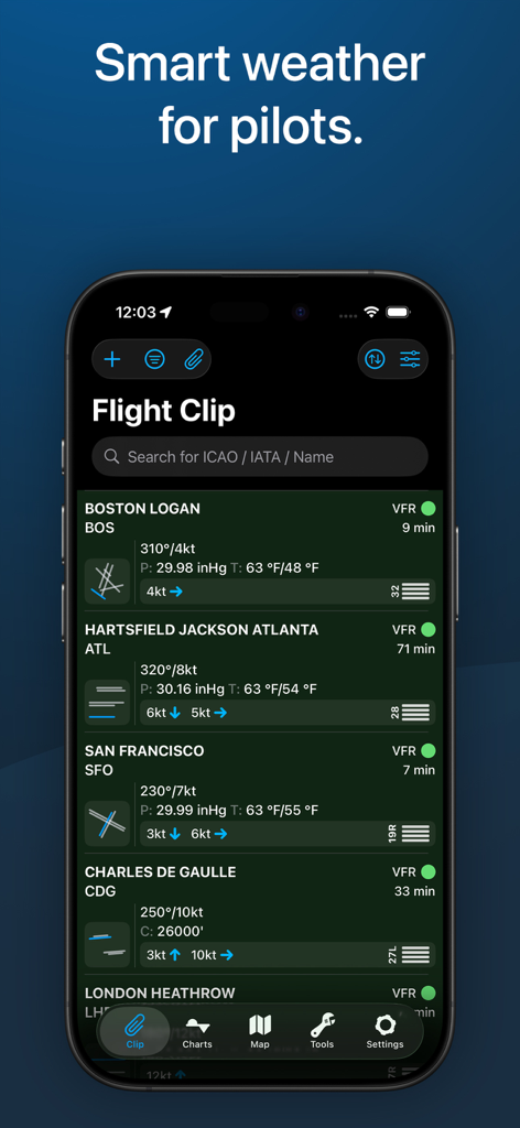
Aviation weather dashboard displaying decoded METAR data and VFR status for major airports
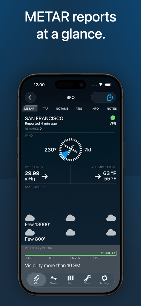
Decoded METAR report for San Francisco airport on StationWeather app
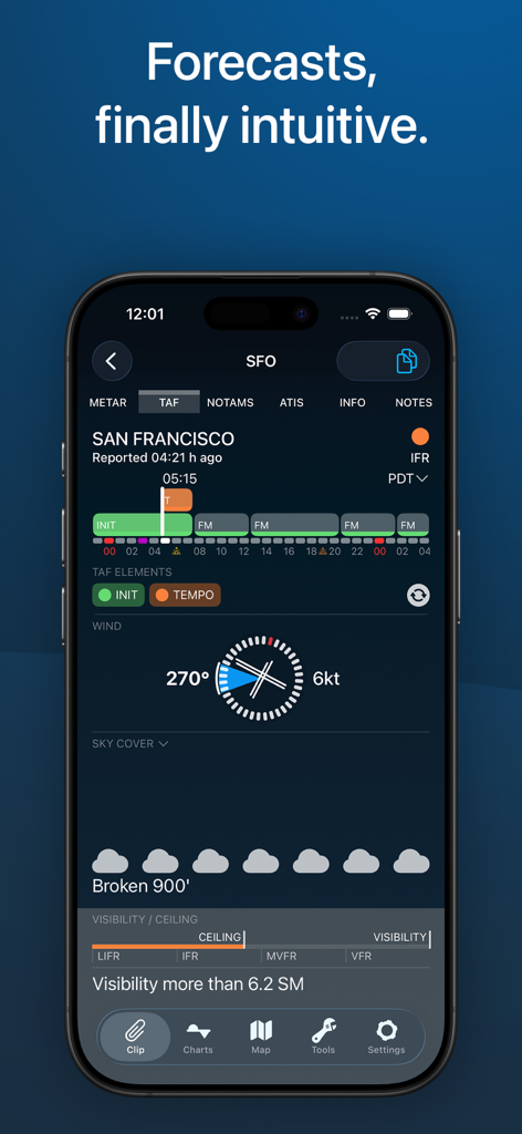
StationWeather app interface displaying a visual and decoded TAF forecast for San Francisco airport featuring wind and sky cover details.
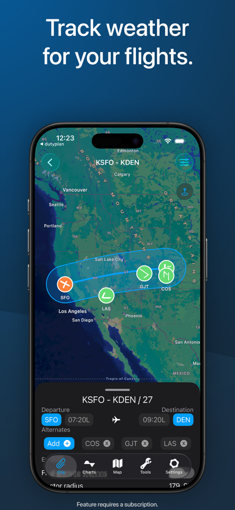
StationWeather app interface displaying a flight route from San Francisco to Denver with integrated weather icons and route planning tools on a map.
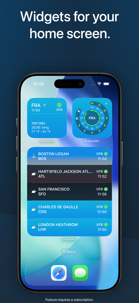
iPhone home screen displaying aviation weather widgets with METAR and TAF data for multiple airports
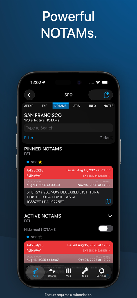
Aviation NOTAM management screen showing color-coded and decoded alerts for SFO airport.
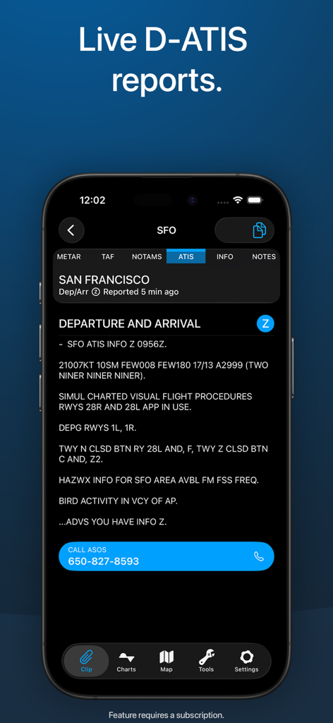
iPhone screenshot of the StationWeather app displaying live D-ATIS reports for San Francisco airport
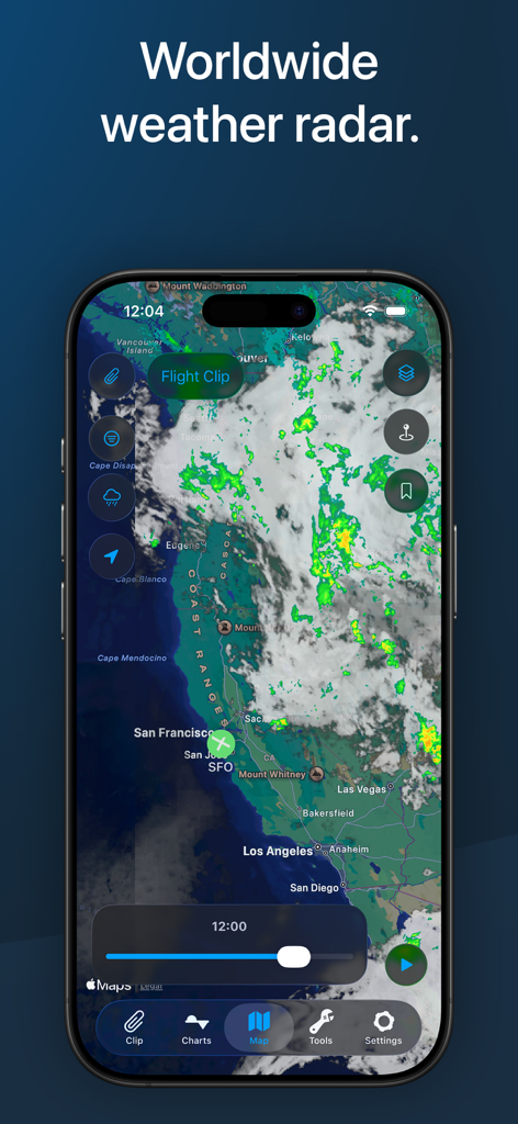
Smartphone screen displaying a detailed aviation weather radar map for flight planning.
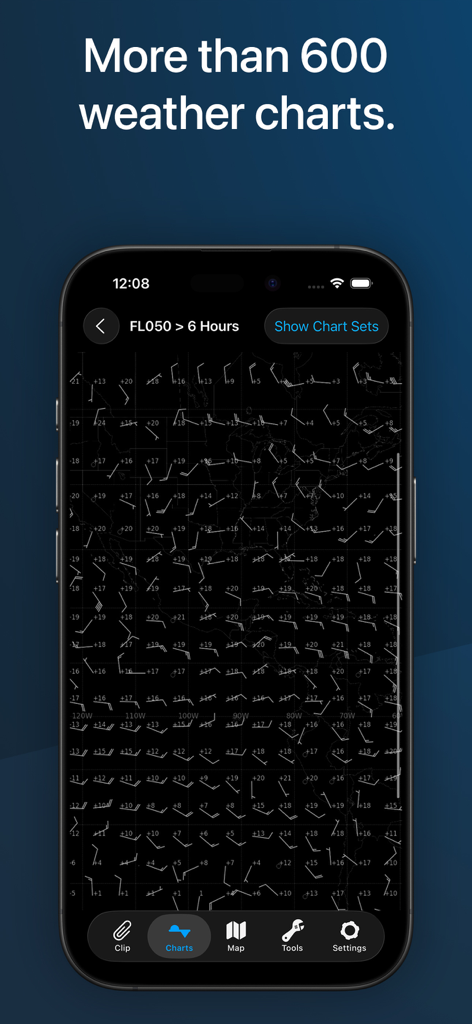
Professional aviation weather chart showing wind barbs and flight data on a map
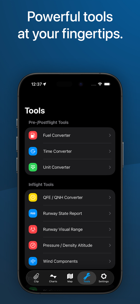
StationWeather app interface showing aviation converters and flight tools
Description
Download
More Like This
Apps with similar features and user experience

Navigraph Charts
Navigraph KB

SkyDemon
Divelements Limited

Airports
Applicate Ltd

OzRunways EFB
OzRunways Pty. Ltd.

fDeck: flight instruments
Darren Yeates

Noisy Goose
Automata Solutions Ltd.

Drone UAV Fly Forecast: AirMap
MONIQ TAP COMPANY LIMITED

Airmate
Myriel Aviation SA

AvPlan EFB
BJA Consulting Pty Ltd
This page is not an official page of the app or its developer, but an independent editorial publication created for informational and commentary purposes. Unless expressly stated otherwise, neither the app nor its developer is affiliated with, endorsed by, sponsored by, authorized by, or otherwise officially connected with MWM, Apple, Google Play, the app publisher, or the app's developer, and nothing on this page implies that the app was developed using MWM's services. Any trademarks, logos, screenshots, and other content remain the property of their respective owners.