This page is not an official page of the app or its developer, but an independent editorial publication created for informational and commentary purposes. Unless expressly stated otherwise, neither the app nor its developer is affiliated with, endorsed by, sponsored by, authorized by, or otherwise officially connected with MWM, Apple, Google Play, the app publisher, or the app's developer, and nothing on this page implies that the app was developed using MWM's services. Any trademarks, logos, screenshots, and other content remain the property of their respective owners.

Spyglass
The wilderness shrinks. This app transforms your device into an off-grid survival multitool, granting mastery over unknown terrain.
Downloads
500k+User Rating
Total Ratings
6.4KPublisher
Category
NavigationLocales
12Latest Version
3.31.5Size
66.1 MBFirst Released
Oct 4, 2009An Analytical Overview for Professional Off-Grid Operations
Key Navigational Capabilities of Spyglass
Robust Offline Mapping
It allows users to access and utilize detailed maps even without internet connectivity, which is critical for navigation in remote and off-grid environments. This tool supports various map styles and providers, facilitating comprehensive route planning and distance measurements.
Advanced Gyrocompass & Calibration
The app provides advanced accuracy improvement techniques, specialized compass modes, and unique calibration methods to deliver the most precise digital compass functionality. This is essential for maintaining accurate bearing and orientation in challenging field conditions.
Augmented Reality Navigation & Multi-Target Tracking
This tool features 3D augmented reality capabilities, displaying real-time object positions, information, and directional guidance overlaid onto the camera view or maps. It allows users to track multiple targets simultaneously, showing crucial details like distance, direction, azimuth, elevation, and estimated time of arrival.
Comprehensive Real-Time GPS Data
It allows users to find and track their location with detailed real-time GPS information, including coordinates in numerous formats, altitude, course, and various speed metrics (current, maximum, vertical). The app supports imperial, metric, nautical, and surveying units, catering to diverse professional needs.
Celestial Navigation & Compass Calibration
The app provides the ability to track the precise positions of stars, the Sun, and the Moon. This feature can be used as a reliable reference for calibrating the compass, offering an invaluable backup and accuracy enhancement for navigation, especially in extreme situations or when other systems are compromised.
Precision Optical Rangefinder
This tool features an optical rangefinder with a reticle, enabling users to measure distances to objects in real-time. This capability is highly valuable for tactical assessment, reconnaissance, and precise distance estimation in the field.
Advanced Angular Measurement Tools
It allows users to leverage integrated tools such as a sextant, angular calculator, and inclinometer to determine the heights of objects and measure distances to them visually. This enhances field assessment capabilities for surveying, positioning, and environmental analysis.
Geotagged Photo Documentation
The app provides functionality to capture images overlaid with comprehensive GPS, positional, and directional data. This feature is useful for creating detailed visual records, crucial for field reporting, evidence collection, or mission debriefs.
Frequently Asked Questions
Everything you need to know about Spyglass
What is Spyglass?
Spyglass is an essential offline GPS app for outdoors and off-road navigation. It provides numerous tools including a hi-tech compass, offline maps, GPS receiver, altimeter, and augmented reality features.
Does Spyglass work offline?
Yes, Spyglass operates as an offline GPS app. It provides offline maps optimized for retina displays, which users can download for navigation without an internet connection.
What navigation tools are included in the Spyglass app?
Spyglass includes a hi-tech compass, gyrocompass, GPS receiver, waypoint tracker, speedometer, altimeter, optical rangefinder, sextant, inclinometer, and a Sun, Moon, and star finder. It also features augmented reality.
Can Spyglass track stars, the Sun, and the Moon?
Yes, Spyglass tracks the positions of stars, the Sun, and the Moon with arc second precision. Users can utilize these celestial bodies to calibrate the compass for maximum accuracy.
How does Spyglass use augmented reality (AR)?
Spyglass operates in 3D and uses augmented reality to display real-time object positions, information, and directions. It overlays this data directly over the camera view or maps.
Can I save custom locations in Spyglass?
Yes, Spyglass allows users to save current positions, add points from maps, and manually enter location coordinates. It also offers a built-in star catalog for saving celestial objects.
What kind of GPS data does Spyglass display?
Spyglass displays detailed real-time GPS data including coordinates in dozens of formats, altitude, course, current, maximum, and vertical speed. It supports imperial, metric, nautical, and surveying units.
Does Spyglass offer different unit measurements?
Yes, Spyglass supports various unit measurements. Users can select imperial, metric, nautical, and surveying units for speed, distance, and other GPS data, configurable in settings.
What is Spyglass PLUS?
Spyglass PLUS is an enhanced version offering specific map sources tailored for activities like hiking, cycling, and skiing. It is available as a subscription.
How do I manage my Spyglass PLUS subscription?
You can turn off automatic renewal for Spyglass PLUS at any time in your iTunes Account Settings after purchase. The subscription expires at the end of the current period upon cancellation.
Can Spyglass measure distances to objects?
Yes, Spyglass features an optical rangefinder to measure distances to objects in real-time, using a reticle similar to sniper sights. It also offers a sextant for visual distance and dimension calculations.
Does Spyglass allow sharing of locations?
Yes, Spyglass allows users to copy, paste, and share locations, coordinates, and map links. It supports multiple formats for convenient sharing.
The following screenshots and description are sourced directly from the app's official store listing and are the property of the app developer.
App Store
Screenshots

The app provides comprehensive navigational data through its heads-up display (HUD) and integrates seamlessly with detailed offline maps for urban environments.
Precision Urban Navigation
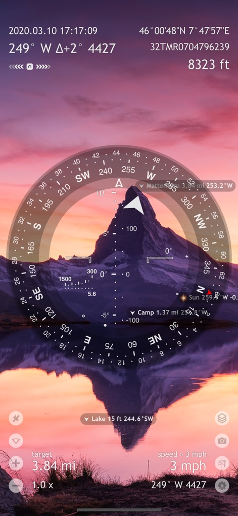
Users can leverage the augmented reality display for real-time object tracking, effortlessly finding key locations like 'Matterhorn' overlaid on the live camera view.
Augmented Reality Guidance

This tool overlays precise navigational data onto high-resolution satellite map imagery, allowing for the easy identification and tracking of custom waypoints such as 'Antenna #1' and 'Antenna #2'.
Off-Grid Expedition Planning

The app offers a specialized dark theme interface for low-light conditions and allows users to track celestial bodies like the Moon and Sun for advanced navigation.
Celestial Navigation Mode

This tool integrates a detailed topographic map view with an advanced HUD, providing users with essential real-time elevation tracking and terrain insights, as shown with 'Zugspitze'.
Topographic Terrain Insight

The app provides a comprehensive destination list, allowing users to efficiently manage numerous waypoints and view their precise coordinate and bearing details.
Waypoint Management System

Users can utilize the sophisticated star finder display to identify and track multiple celestial bodies, such as 'Betelgeuse' and 'Rigel', for accurate night navigation.
Advanced Star Navigation

The app provides a comprehensive real-time GPS data dashboard, offering critical metrics like precise altitude and current speed for complete situational awareness.
Detailed GPS Metrics

This tool features a detailed satellite skyplot visualization showing satellite positions and a clear signal-to-noise ratio (SNR) display for optimal GPS reception.
Satellite Signal Analysis

The app offers extensive customization options, including specialized unit settings like 'Milspec units' and advanced navigation configurations such as 'MGRS (WGS84)' grid coordinates.
Customizable Precision Control
Description
Download
More Like This
Apps with similar features and user experience

AllTrails: Hike, Bike & Run
AllTrails, Inc.

Pedometer++
Cross Forward Consulting, LLC

Organic Maps: Offline Map
Organic Maps OU

Gaia GPS: Mobile Trail Maps
Trailbehind, INC.

Offline hiking maps: Mapy.com
Seznam.cz a.s.

Hiking Map Poland
Mapa Turystyczna sp. z o.o.

MapOut
Valnova GmbH

FarOut: Offline GPS Trail Maps
Atlas Guides DE, Inc.

Norgeskart
Norgeskart AS
This page is not an official page of the app or its developer, but an independent editorial publication created for informational and commentary purposes. Unless expressly stated otherwise, neither the app nor its developer is affiliated with, endorsed by, sponsored by, authorized by, or otherwise officially connected with MWM, Apple, Google Play, the app publisher, or the app's developer, and nothing on this page implies that the app was developed using MWM's services. Any trademarks, logos, screenshots, and other content remain the property of their respective owners.