This page is not an official page of the app or its developer, but an independent editorial publication created for informational and commentary purposes. Unless expressly stated otherwise, neither the app nor its developer is affiliated with, endorsed by, sponsored by, authorized by, or otherwise officially connected with MWM, Apple, Google Play, the app publisher, or the app's developer, and nothing on this page implies that the app was developed using MWM's services. Any trademarks, logos, screenshots, and other content remain the property of their respective owners.

Topo Maps+
Plan, execute, and track your adventures with high-resolution offline maps, public and private land boundaries, and seamless integration across your iPhone, Mac, and Apple Watch.
Downloads
1M+User Rating
Total Ratings
9K+Publisher
Category
NavigationLocales
7Latest Version
9.6.2Size
229.8 MBFirst Released
Jul 30, 2013Master Every Trail and Territory
From desktop planning to wrist-based navigation, Topo Maps+ equips you with professional-grade tools and offline reliability for safe, smart backcountry exploration.
Seamless Cross-Device Sync
Plan your complex routes on a Mac or iPad and automatically sync them to your iPhone and Apple Watch for a unified navigation experience.
Unfailing Offline Navigation
Download high-resolution topographic maps and use real-time GPS tracking to stay on course, even in the deepest cellular dead zones.
Frequently Asked Questions
Everything you need to know about Topo Maps+
Does Topo Maps+ support offline map usage?
Yes, Topo Maps+ allows users to compare and download maps for offline use. All maps and overlays are downloadable to ensure access without an internet connection.
Can I record my tracks and hikes with Topo Maps+?
Yes, Topo Maps+ allows you to record your tracks, showing where you have been. The app also features progress on trail and photo waypoints during your hike.
Does Topo Maps+ offer 3D map views?
Yes, Topo Maps+ provides 3D map views. This feature displays mountainous terrain with depth and detail, as shown with Mount Rainier and Camp Muir.
Is Topo Maps+ compatible with Apple Watch?
Yes, Topo Maps+ integrates with Apple Watch. You can download maps, pan and zoom, drop waypoints, and record tracks directly from your watch.
What planning tools does Topo Maps+ offer for backcountry adventures?
Topo Maps+ offers planning tools like comparing and downloading maps, combining overlays, smart route-building, waypoints, and sharing custom maps. It also includes public, private, and hunting land boundaries.
Does Topo Maps+ provide public and private land boundary information?
Yes, Topo Maps+ includes public, private, and hunting land boundaries. For Elite subscribers, it provides parcel information and ownership contact details.
Does Topo Maps+ support Apple CarPlay?
Yes, Topo Maps+ supports Apple CarPlay. You can navigate to trailheads and receive turn-by-turn directions on USFS Roads using CarPlay.
What are the subscription levels available for Topo Maps+?
Topo Maps+ offers three subscription levels: FREE, Topo Maps+ Pro, and Topo Maps+ Elite. Each level provides different access to features and map resolutions.
What features are included in the free level of Topo Maps+?
The FREE level of Topo Maps+ allows you to view low-resolution maps, record your tracks, and access limited features.
How can I manage my Topo Maps+ subscription?
You can manage and cancel your Topo Maps+ subscriptions by navigating to your account settings on the App Store after purchase.
Where can I find the privacy policy for Topo Maps+?
The privacy policy for Topo Maps+ is available at the provided URL: https://topomaps.co/info/privacy.
Does Topo Maps+ affect battery life?
Yes, continued use of GPS running in the background with Topo Maps+ can significantly decrease your device's battery life.
Can I print maps from Topo Maps+?
Yes, Topo Maps+ allows users to print custom maps and routes. This feature is part of the app's planning tools for your backcountry adventures.
The following screenshots and description are sourced directly from the app's official store listing and are the property of the app developer.
App Store
Screenshots
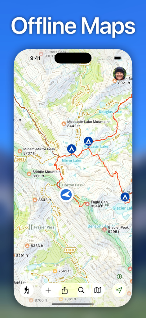
Topo Maps plus app showing offline topographic map with a red trail route and campsite icons for backcountry hiking.
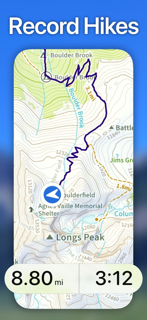
Mobile app screenshot showing a recorded hike path on a topographic map with distance and time statistics.
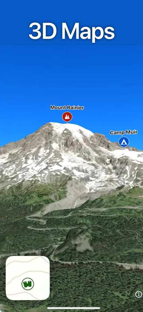
3D topographic map of Mount Rainier and Camp Muir in the Topo Maps plus app
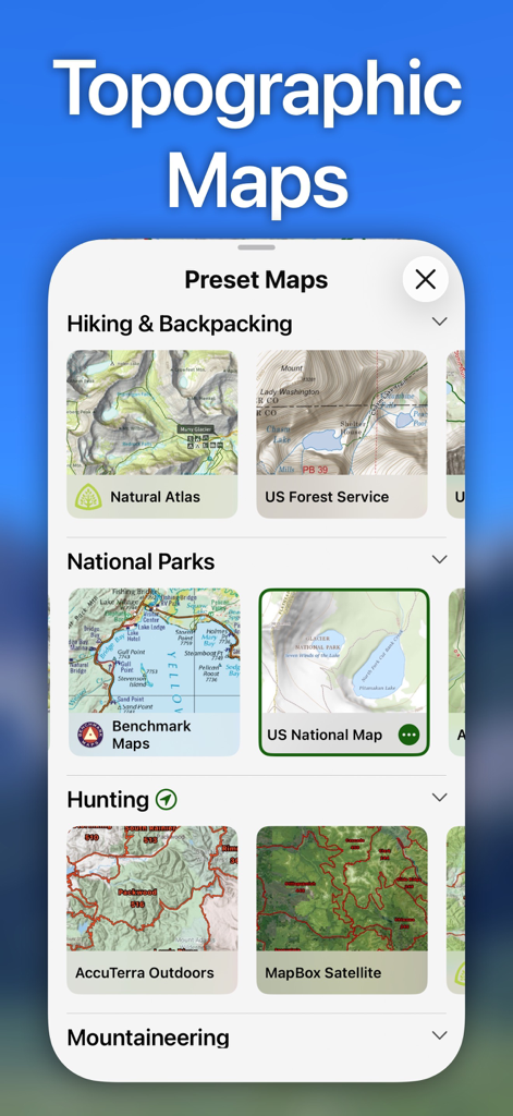
A screenshot of the Topo Maps plus app showing preset map selections for hiking, national parks, and hunting.
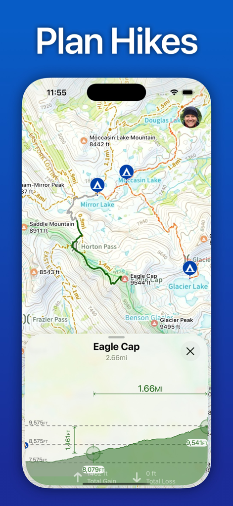
Topo Maps plus app interface showing a topographic map with a planned hiking route and elevation gain chart.
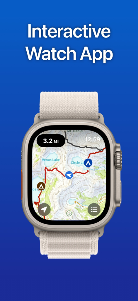
Topo Maps plus app on Apple Watch showing interactive topographic trail map
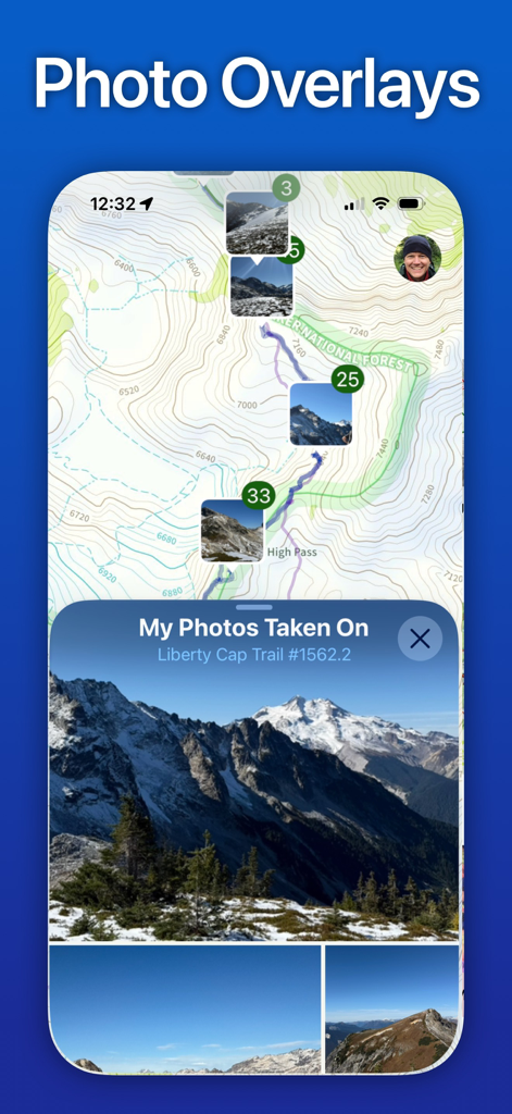
Topo Maps plus app displaying geotagged photos as overlays on a topographic hiking trail map.
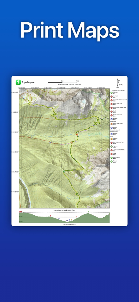
A printable topographic map showing a hiking route with elevation profile and trail waypoints.
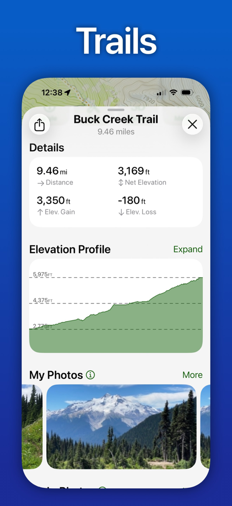
Screenshot of Topo Maps plus app showing Buck Creek Trail distance, elevation gain, and profile graph.
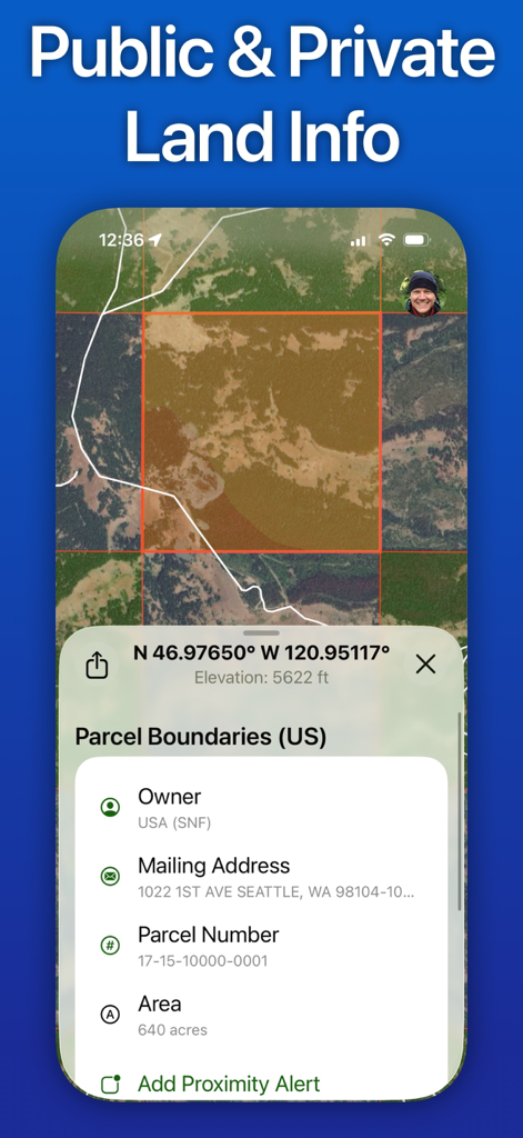
Topo Maps+ app interface showing US parcel boundaries and land ownership information on a satellite map
Description
Download
More Like This
Apps with similar features and user experience

AllTrails: Hike, Bike & Run
AllTrails, Inc.

Pedometer++
Cross Forward Consulting, LLC

Organic Maps: Offline Map
Organic Maps OU

Gaia GPS: Mobile Trail Maps
Trailbehind, INC.

Offline hiking maps: Mapy.com
Seznam.cz a.s.

Hiking Map Poland
Mapa Turystyczna sp. z o.o.

MapOut
Valnova GmbH

FarOut: Offline GPS Trail Maps
Atlas Guides DE, Inc.

Norgeskart
Norgeskart AS
This page is not an official page of the app or its developer, but an independent editorial publication created for informational and commentary purposes. Unless expressly stated otherwise, neither the app nor its developer is affiliated with, endorsed by, sponsored by, authorized by, or otherwise officially connected with MWM, Apple, Google Play, the app publisher, or the app's developer, and nothing on this page implies that the app was developed using MWM's services. Any trademarks, logos, screenshots, and other content remain the property of their respective owners.